Westport, Connecticut
| Westport, Connecticut | |||
|---|---|---|---|
| Town | |||
|
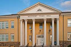
Westport Town Hall | |||
| |||
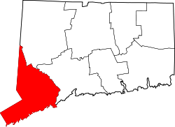
 Location in Fairfield County and the state of Connecticut. | |||
| Coordinates: 41°07′24″N 73°20′49″W / 41.12333°N 73.34694°WCoordinates: 41°07′24″N 73°20′49″W / 41.12333°N 73.34694°W | |||
| Country | United States | ||
| State | Connecticut | ||
| NECTA | Bridgeport-Stamford | ||
| Region | South Western Region | ||
| Incorporated | May 28, 1835 | ||
| Government | |||
| • Type | Representative town meeting | ||
| • First Selectman | Jim Marpe (R)[1][2] | ||
| • Second Selectman | Avi Kaner (R) | ||
| • Third Selectwoman | Helen Garten (D) | ||
| Area | |||
| • Total | 33.3 sq mi (86.2 km2) | ||
| • Land | 20.0 sq mi (51.8 km2) | ||
| • Water | 13.3 sq mi (34.5 km2) | ||
| Elevation | 26 ft (8 m) | ||
| Population (2010)[3] | |||
| • Total | 26,391 | ||
| • Density | 790/sq mi (310/km2) | ||
| Time zone | Eastern (UTC-5) | ||
| • Summer (DST) | Eastern (UTC-4) | ||
| ZIP code | 06880 | ||
| Area code(s) | 203 | ||
| FIPS code | 09-83500 | ||
| GNIS feature ID | 0213532 | ||
| Website | http://www.westportct.gov/ | ||

Westport is a coastal town of colonial origin located along Long Island Sound in Fairfield County, Connecticut, 47 miles (76 km) northeast of New York City in the United States.[4] The town had a population of 26,391 according to the 2010 U.S. Census and in 2008 ranked the tenth wealthiest town in the U.S. with populations between 20,000 and 65,000, and second in the state.[3][5]
History

Archaeological finds led to what are currently the earliest identified inhabitants of the Westport area that date back 7,500 years.[6] Records from the first white settlers report the Pequot Indians living in the area which they called Machamux translated by the colonialists as beautiful land.[7] Settlement by colonialists dates back to the five Bankside Farmers; whose families grew and prospered into a community that continued expanding. The community had its own ecclesiastical society, supported by independent civil and religious elements, enabling it to be independent from the Town of Fairfield.[8] The settlers arrived in 1693, having followed cattle to the isolated area known to the Pequot as the "beautiful land".[7] As the settlement expanded its name changed: it was briefly known as "Bankside" in 1693, officially named Green's Farm in 1732 in honor of Bankside Farmer John Green and in 1835 incorporated as the Town of Westport.[6][9]

During the revolutionary war—on April 25, 1777, a 1,850 strong British force under the command of the Royal Governor of the Province of New York, Major General William Tryon landed on Compo Beach to destroy the Continental Army’s military supplies in Danbury.[10] Minutemen from Westport and the surrounding areas crouched hiding whilst Tryon's troops passed and then launched an offensive from their rear. A statue on Compo beach commemorates this plan of attack with a crouching Minuteman facing away from the beach; looking onto what would have been the rear of the troops.[11]
The Town of Westport was officially incorporated on May 28, 1835, with lands from Fairfield, Weston and Norwalk.[6][12] Daniel Nash led 130 people of Westport in the petitioning of the Town of Fairfield for Westport’s incorporation. The driving force behind the petition was to assist their seaport’s economic viability that was being undermined by neighboring towns’ seaports.[13] For several decades after that, Westport was a prosperous agricultural community distinguishing itself as the leading onion-growing center in the U.S.[14] Blight caused the collapse of Westport's onion industry leading to the mills and factories replacing agricultural as the town's economic engine.[8]
Agriculture was Westport’s first major industry. By the 19th century, Westport had become a shipping center in part to transport onions to market.
Starting around 1910 the town experienced a cultural expansion.[6][15] During this period artists, musicians, and authors such as F. Scott Fitzgerald moved to Westport to be free from the commuting demands experienced by business people.[16] The roots of Westport’s reputation as an arts center can be traced back to this period during which it was known as a "creative heaven."[6]
In the 20th century a combination of industrialization, and popularity among New Yorkers attracted to fashionable Westport—which had attracted many artists and writers—resulted in farmers selling off their land. Westport changed from a community of farmers to a suburban development.[17][18]
In the 1950s through to the 1970s baby boomers relocating from New York to the suburbs discovered Westport's culture of artists, musicians and authors.[15] The population grew rapidly assisted by the ease of commuting to New York City and back again to rolling hills and the "natural beauty of the town."[6][19] By this time Westport had "chic New York-type fashion shopping."[20][21] And a school system with a good reputation, all factors contributing to the growth.[22][23]
Westport's population grew rapidly from the 1950s to 1970s. This expansion was driven by the town's proximity to New York City, its school system's reputation, "chic New York-type fashion shopping" and the "natural beauty of the town".[15][19][20][21][22][23] By the 21st century, Westport had developed into a center for finance and insurance (23%), and professional, scientific and technical services (21%).[24]
Geography and environment
According to the United States Census Bureau, Westport has a total area of 33.3 square miles (86 km2). 20.0 square miles (52 km2) or 60.02% of it is land and 13.3 square miles (34 km2) or 39.98% is water.
Westport is bordered by Norwalk on the west, Weston to the north, Wilton to the northwest, Fairfield to the east and Long Island Sound to the south.
Climate
| Climate data for Westport, Connecticut | |||||||||||||
|---|---|---|---|---|---|---|---|---|---|---|---|---|---|
| Month | Jan | Feb | Mar | Apr | May | Jun | Jul | Aug | Sep | Oct | Nov | Dec | Year |
| Record high °F (°C) | 69 (21) |
74 (23) |
85 (29) |
96 (36) |
97 (36) |
97 (36) |
102 (39) |
104 (40) |
97 (36) |
86 (30) |
82 (28) |
76 (24) |
104 (40) |
| Average high °F (°C) | 39 (4) |
42 (6) |
51 (11) |
63 (17) |
73 (23) |
81 (27) |
86 (30) |
84 (29) |
76 (24) |
65 (18) |
54 (12) |
43 (6) |
63.1 (17.3) |
| Average low °F (°C) | 23 (−5) |
25 (−4) |
31 (−1) |
41 (5) |
51 (11) |
60 (16) |
66 (19) |
65 (18) |
59 (15) |
46 (8) |
38 (3) |
28 (−2) |
44.4 (6.9) |
| Record low °F (°C) | −18 (−28) |
−14 (−26) |
−6 (−21) |
16 (−9) |
28 (−2) |
35 (2) |
40 (4) |
37 (3) |
28 (−2) |
16 (−9) |
7 (−14) |
−13 (−25) |
−18 (−28) |
| Average precipitation inches (mm) | 4.0 (102) |
3.5 (89) |
4.7 (119) |
4.8 (122) |
4.7 (119) |
4.6 (117) |
4.1 (104) |
4.2 (107) |
4.9 (124) |
4.8 (122) |
4.5 (114) |
4.4 (112) |
53.2 (1,351) |
| Average snowfall inches (cm) | 7.6 (19.3) |
7.8 (19.8) |
4.9 (12.4) |
0.7 (1.8) |
0 (0) |
0 (0) |
0 (0) |
.4 (1) |
0 (0) |
0 (0) |
0.6 (1.5) |
4.6 (11.7) |
26.6 (67.5) |
| Average precipitation days (≥ 0.01 in) | 6.3 | 5.9 | 6.8 | 7.3 | 7.7 | 7.1 | 6.6 | 6.5 | 6.3 | 5.7 | 6.4 | 6.3 | 78.9 |
| Average snowy days (≥ 0.1 in) | 3.5 | 2.9 | 1.2 | 0 | 0 | 0 | 00 | 0 | 0 | 0 | 0.1 | 1.4 | 9.1 |
| Source: The Weather Channel[25][26] | |||||||||||||
Topology
Both the train station and a total of 26 percent of town residents live within the 100-year floodplain. The floodplain was breached in 1992 and 1996 resulting in damage to private property, the 1992 flooding of the train station parking lot and the implementation of flood mitigation measures that include town regulations that affect renovations and additions to building within the floodplain zone.
Neighborhoods
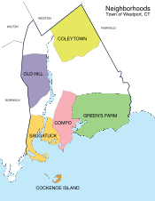
- Saugatuck – around the Westport railroad station near the southwestern corner of the town – a built-up area with some restaurants, stores and offices. Saugatuck originates from the Paugussett tribe meaning mouth of the tidal river.
- Saugatuck Shores – A curved peninsula surrounded by the Long Island Sound, this area was once part of the town of Norwalk. Today several hundred residents live on the peninsula, which became part of Westport in the 1960s.
- Saugatuck Island – founded in the 1890s as Greater Marsh Shores, the island was renamed to its current name in 1920 and became a special taxing district on November 5, 1984.
- Downtown Westport - The area around Post Road and Main Street on and near the Saugatuck River that serves as the center of Westport, with many shops and restaurants. There has been recent growth in the downtown area, including Levitt Pavilion, National Hall (The area where Post and Riverside intersect), and Bedford square (opening in 2017), a mixed use development on Church St, Elm St, Main St and Post Rd that will have apartments, public spaces, including a courtyard, underground parking, stores, and restaurants, as well as the incorporation of the historic Bedford Mansion. [27]
- Greens Farms – is Westport's oldest neighborhood starting around Hillspoint road and ending at Westport's boundary on the east side.[7]
- Cockenoe Island (pronounced "KuhKEEnee") – just off the southeastern coast of the town. Cockenoe Island is an uninhabited island that was purchased by Westport for $212,740 from the United Illuminating Company in 1969 so that the company could not use the land to build a nuclear plant.[7]
- Old Hill – west of the Saugatuck River and north of the Post Road, a historic section of town with many homes from the Revolutionary and Victorian eras. Prior to the road being called the Boston Post Road it was called the Connecticut Turnpike.[28]
- Coleytown – Located at the northern edge of town, near the Weston town line. Home to Coleytown fire station, Middle and Elementary school.
- Compo – Located around the main beach in the town, Compo Beach. Compo (Compaug), can be traced back to the early Paugussett tribe and means the bear's fishing ground.[29]

Demographics
| Historical population | ||
|---|---|---|
| Year | Pop. | ±% |
| 1840 | 1,803 | — |
| 1850 | 2,651 | +47.0% |
| 1860 | 3,293 | +24.2% |
| 1870 | 3,361 | +2.1% |
| 1880 | 3,477 | +3.5% |
| 1890 | 3,715 | +6.8% |
| 1900 | 4,017 | +8.1% |
| 1910 | 4,259 | +6.0% |
| 1920 | 5,114 | +20.1% |
| 1930 | 6,073 | +18.8% |
| 1940 | 8,258 | +36.0% |
| 1950 | 11,667 | +41.3% |
| 1960 | 20,955 | +79.6% |
| 1970 | 27,318 | +30.4% |
| 1980 | 25,290 | −7.4% |
| 1990 | 24,410 | −3.5% |
| 2000 | 25,749 | +5.5% |
| 2010 | 26,391 | +2.5% |
| Source: CT.gov | ||
As of the census of 2000, there were 26,644 people, 9,586 households, and 7,170 families residing in the town. The population density was 1,286.7 people per square mile (496.8/km²). There were 10,065 housing units at an average density of 503.0 per square mile (194.2/km²).
According to the 2010 Census, the population of Westport was 92.6% White, 4.0% Asian, 1.2% Black or African American, and 0.1% American Indian. Individuals from other races made up 0.6% of Westport's population while individuals from two or more races made up 1.6%.[30] In addition, Hispanics of any race made up 3.5% of Westport’s population. About 29.8% of Westport residents were younger than age 18 as of 2010; higher than the U.S. average of 24%.
According to the 2000 Census, there were 9,586 households, of which 38.4% had children under the age of 18 living with them, 66.1% were married couples living together, 6.8% have a woman whose husband does not live with her, and 25.2% were non-families. 20.8% of all households were made up of individuals and 8.8% had someone living alone who was 65 years of age or older. The average household size was 2.66 and the average family size was 3.10.
In the town the population was spread out with 27.9% under the age of 18, 2.7% from 18 to 24, 26.2% from 25 to 44, 28.0% from 45 to 64, and 15.1% who were 65 years of age or older. The median age was 41 years. For every 100 females there were 90.7 males. For every 100 females age 18 and over, there were 86.3 males.
According to a 2007 estimate, the median income for a household in the town was $147,391, and the median income for a family was $176,740. As of the 2000 Census, males had a median income of $100,000 versus $53,269 for females. The per capita income for the town was $73,664. 2.6% of the population and 1.5% of families were below the poverty line. Out of the total people living in poverty, 2.7% are under the age of 18 and 2.1% are 65 or older.
Westport was named the fifth top-earning city in the US, with a median family income of $193,540 and median home price of $1,200,000 in July 2008.[31]
Government
The town switched to a Representative Town Meeting style governance in 1949. The government consists of a three-member Board of Selectmen, a Representative Town Meeting (RTM), a Board of Finance, a Board of Education, a Planning and Zoning Commission, and various other commissions, boards, and committees.
Taxes
In 2005, the mill rate for Westport was 12.97[32] and is expected to increase to 17.43 for fiscal year 2013.[33]
Fire Department
The town of Westport is protected by the paid, full-time firefighters of the Westport Fire Department (WFD). Established in 1929, the Westport Fire Department currently operates out of 4 Fire Stations, located throughout the town, and maintains a fire apparatus fleet of 4 Engines, 1 Truck, 1 Rescue, 1 Fireboat, 1 High Water Unit, 1 Utility Unit, and a Shift Commander's Unit. The Westport Fire Department responds to, on average, approximately 4,000 emergency calls annually.[34]
Below is a complete listing of all fire station locations and apparatus in the town of Westport.
| Engine company | Truck company | Special unit | Command unit | Address | Neighborhood |
|---|---|---|---|---|---|
| Engine 2 | Truck 1 | Rescue 3, Fireboat, High Water Unit, Utility Unit | Car 3 (Shift Commander) | 515 Post Rd. E. | Downtown |
| Engine 4 | 555 Riverside Ave. | Saugatuck | |||
| Engine 5 | 66 Center St. | Greens Farms | |||
| Engine 6 | FireBoat | 61 Easton Rd. | Coleytown |
Education
Schools
Public schools

Staples High School is Westport's only public high school.
The district has two middle schools (Grades 6 to 8) – Bedford Middle School and Coleytown Middle School – with a total of 1,321 students. In September 2009, Bedford Middle School was awarded the government-honored Blue Ribbon Award. In 2011, Out of 298 middle schools, Coleytown Middle and Bedford Middle schools were ranked No. 1 and No. 2 in the state, respectively.[35]
There are five elementary schools (Kindergarten to Grade 5) with a total of 2,556 students:
- Coleytown Elementary School[36]
- King's Highway Elementary School[37]
- Green's Farms Elementary School[38]
- Saugatuck Elementary School[39]
- Long Lots Elementary School[40]
There are a number of preschools in Westport, including Stepping Stones Pre-school, Greens Farms Nursery School, Saugatuck Nursery School, Earthplace Nursery School and the YMCA Childcare.[41][42][43][44]
For the 2009–10 fiscal year, the school district's adopted budget is $110.6 million.[45] The school district had an estimated $109.1 million budget for the 2009–10 fiscal year, giving it an average per pupil expenditure of $16,266.[46] The average 2010 class size for kindergarten through first grade was 22 students and 25 students for second through fifth grade.[47]
Private schools
Greens Farms Academy, located in the 1920s Vanderbilt estate overlooking Long Island Sound, is a K-12 private preparatory school located in the Greens Farms section of town. Pierrepont School, opened in 2002 on Sylvan Road, is a private K-12 school for gifted students.

The Westport Library features changing displays of art from area artists.
Scientific institutions
The Rolnick Observatory, operated by the Westport Astronomical Society, is open to the public for free on clear Wednesday and Thursday evenings. The observatory is located at 182 Bayberry Lane, on a former Nike missile site.[48][49]
Earthplace, The Nature Discovery Center, is a natural history museum, nature center and wildlife sanctuary located at 10 Woodside Lane. The organization is dedicated to the promotion of public environmental education, preservation and conservation. Activities include maintaining a 62-acre (250,000 m2) open space wildlife sanctuary with trails, presenting public nature education programs, a water quality monitoring program, an interactive nature discovery area, a nursery school and summer camp.
Media
Westport's first newspaper dates back to the printing and publication of the first issue of The Saugatuck Journal on December 26, 1828.[16][50]
Westport is served by both English-language newspapers and news websites including Westport News and WestportNow, as well as the Westport Minuteman. The town is also home to a monthly magazine Westport.
Economy
Commerce and industry
There are three periods in Westport's economic and industrial history. First was farming, then industry and manufacturing, and finally services: financial, professional, scientific, and technical.[24][51]
- Farming – From 1648 with the settlement and commencement of farming at Bankside for the next two and half centuries Greens Farms flourished as an agricultural area. At its peak From 1861–1865 Westport was the largest onion seller to the U.S. Army during the Civil War in the United States. 75 farmers contributed to the onion industry that saw up to ten dollars for a barrel of white onions sold to the New York City market. 89–95 The onion industry ended with the arrival of the cutworm which wiped out the community's crop.[51]
- Industrialization – in the 20th century, Westport's manufacturing activities expanded mills and factories and it became a shipping center.
- Service industry – the financial services sector employs 7,171 in Westport; half of whom commute daily to Westport.[24] The financial services industry is a major segment of the local economy. The major financial services companies in Westport now are Bridgewater Associates, a global investment manager and Westport's largest employer, Canaan Partners, an early stage venture capital firm focusing on IT and life sciences, and BNY Mellon.[52] Professional, scientific, and technical services companies include Terex, a Fortune 500 company manufacturing industrial equipment and offering professional and technical services around those products, and dLife, a multimedia diabetes education (and marketing) company.
Nonprofits

- The Westport Country Playhouse, founded in 1930, is a regional theater known for its excellent theatrical performances.[53] After Paul Newman moved to Westport in 1960, he became a principal "driving force" behind the playhouse reported as "one the country’s most respected summer theaters."[53] The playhouse went through a renovation process that was completed in 2005 on its seventy-fifth anniversary.[6][8]
- Save the Children, the American charity, governed entirely separately from the British charity of the same name, was headquartered in Westport before moving to Fairfield.[6][54]
- The Smith Richardson Foundation, a public policy think tank, is headquartered in Westport, Connecticut.
Architecture

This is a list of structures on the National Register of Historic Places in Westport:
| [55] | Name on the Register[56] | Image | Date listed[57] | Location | City or town | Description |
|---|---|---|---|---|---|---|
| 1 | The Allen House | Upload image | (#10000492) |
4 Burritt's Landing North 41°06′57″N 73°22′32″W / 41.115833°N 73.375556°W |
Westport | Built in 1958, the house is the only known example in Westport of work by Chicago architect Roy Binkley, Jr..[58] |
| 2 | Bradley-Wheeler House | 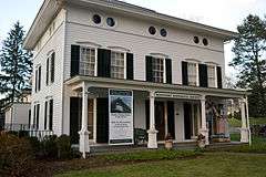 |
(#84000791) |
25 Avery Pl. 41°08′39″N 73°21′41″W / 41.144167°N 73.361389°W |
Westport | Headquarters and museum of the Westport Historical Society |
| 3 | Compo-Owenoke Historic District | Upload image | (#91000393) |
Roughly bounded by Gray's Creek, Compo Rd. S., and Long Island Sound 41°06′22″N 73°21′18″W / 41.106111°N 73.355°W |
Westport | |
| 4 | Godillot Place |  |
(#77001396) |
60, 65 Jesup Rd. 41°08′25″N 73°21′35″W / 41.140278°N 73.359722°W |
Westport | A Stick style house built in 1879 , an associated cottage, and a carriage barn.[59] |
| 5 | Green Farms School | Upload image | (#91000391) |
Junction of Morningside Dr. S. and Boston Post Rd., In the Greens Farms 41°08′13″N 73°19′31″W / 41.136944°N 73.325278°W |
Westport | Tudor Revival style school built in 1925, designed by architect Charles Cutler[60] |
| 6 | Kings Highway North Historic District | Upload image | (#98000884) |
Roughly along Kings Highway, N., from Wilton Rd. to Woodside Ave. 41°08′26″N 73°22′06″W / 41.140556°N 73.368333°W |
Westport | |
| 7 | Mill Cove Historic District | Upload image | (#91000392) |
Between Compo Mill Cove and Long Island Sound 41°06′47″N 73°20′32″W / 41.113056°N 73.342222°W |
Westport | |
| 8 | National Hall Historic District |  |
(#84000812) |
Riverside Ave., Wilton and Post Rds.; in downtown Westport, on the west side of (and abutting) the Saugatuck River and north side of Post Road East 41°08′25″N 73°21′54″W / 41.140278°N 73.365°W |
Westport | |
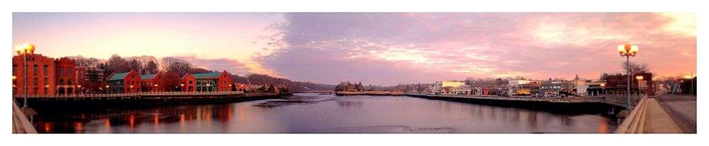
| 9 | Saugatuck River Bridge | .jpg) |
(#87000126) |
CT 136 41°07′22″N 73°22′10″W / 41.122778°N 73.369444°W |
Westport | From 1884, a swinging bridge |
| 10 | Saugatuck River Railroad Bridge | .jpg) |
(#87000846) |
Amtrak right-of-way at the Saugatuck River 41°07′10″N 73°22′08″W / 41.119444°N 73.368889°W |
Westport | |
| 11 | Shambaugh House | Upload image | (#99000432) |
12 Old Hill Rd. 41°08′38″N 73°22′12″W / 41.143889°N 73.37°W |
Westport | |
| 12 | Town Hall | 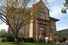 |
(#82004343) |
90 Post Rd. E. 41°08′28″N 73°21′39″W / 41.141111°N 73.360833°W |
Westport | The former Town Hall |
| 13 | Westport Bank and Trust Company | 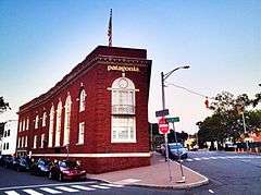 |
(#06000593) |
87 Post Rd. E., in downtown Westport 41°08′30″N 73°21′40″W / 41.141667°N 73.361111°W |
Westport |
Parks and recreation
Comprising 234 acres (0.95 km2), Sherwood Island State Park is located on Long Island Sound and includes beach access. Compo Beach and Burying Hill Beach are municipal beaches that are open to out-of-town visitors in the summer for a fee. The state's 9/11 memorial was put in Sherwood Island State Park in Westport; on a clear day the New York City skyline can be seen.[61]

In 1960, Westport purchased Longshore Club Park.
In 2011, Paul Newman's estate gave land to Westport to be managed by the Aspetuck Land Trust.[62]
In 2010, the historic Wakeman Farm was reopened to the public as the Wakeman Town Farm and Sustainability Center. The town's website describes as a "organic demonstration homestead open to the public. The Farm is a model facility created to educate the community with local healthy food production, responsible land stewardship, sustainable practices and community service orientation." [63]
Transportation

Interstate 95, the Merritt Parkway, and U.S. 1, as well as the Saugatuck River, run through Westport.
Westport has two train stations, Green's Farms and Westport on the Metro-North Railroad's New Haven Line, which serves Stamford and Grand Central Terminal in New York City or New Haven-Union Station. This line is shared with Amtrak trains as it is part of the Northeast Corridor, but no Amtrak services stop at Green's Farms or Westport. The nearest Amtrak stations are at Bridgeport (10 miles) and Stamford (12 miles).
In popular culture
Music and musicals
- One of the most popular tracks on REO Speedwagon's eponymous debut album, released on Epic Records in 1971, was "157 Riverside Avenue". The title refers to the Westport address where the band stayed during the recording process.
- In the musical Rent, Benny is married to Alison Grey of Westport, who comes from a wealthy family.
Television
- Westport is where the Ricardos and the Mertzes moved to when Lucy and Ricky bought a house in the country on I Love Lucy.
- Westport was the location of the fictional residence (1164 Morning Glory Circle) of Darrin and Samantha Stephens on the television series Bewitched.[64]
- The Twilight Zone had one episode called "A Stop at Willoughby", wherein the main character worked in NYC and commuted by train to his home in Westport.[65] It aired on May 6, 1960, and the episode was written by then-Westport resident Rod Serling.
- In the television series The Dick Van Dyke Show, Alan Brady, the star of the show that Rob Petrie worked for, lived in Westport.
- In the television series The West Wing, Bradley Whitford plays Josh Lyman, the White House Deputy Chief of Staff, who comes from a wealthy family from Westport.
- In the television show Boy Meets World, Anthony Tyler Quinn plays Mr. Jonathan Turner, main character's high school teacher, who comes from Westport.
- The television show American Housewife is set in Westport.
Literature and film – Westport has been the subject, inspiration, or location for written and cinematic works:
- In the popular book series, Percy Jackson and the Olympians by Rick Riordan, the main antagonist, Luke Castellan, formerly lived in Westport.
- In 1911, part of the film The Charity of the Poor was filmed in Saugatuck[66] followed up the next year, in 1912, with the film In Time of Peril.
- The 1956 movie The Man in the Gray Flannel Suit, with Gregory Peck, was based on the book of the same name by Sloan Wilson which was itself set partly in Westport. Portions of the movie were filmed on location in Westport. In particular, shots of the Westport Saugatuck train station can be seen, as well as a sequence towards the end of the movie showing a still recognizable Westport Main Street in the late 1950s.
- The 1958 production of Rally 'Round the Flag, Boys! was also set in Westport[67]
- The 1968 film The Swimmer starring Burt Lancaster and based on a short story by John Cheever, was partially filmed in Westport backyard pools.[68]
- In 1972 the local filmmaker Sean Cunningham shot The Last House on the Left which was his first feature film.[69] Three years later the 1975 production of The Stepford Wives was released featuring scenes shot in a Williamsburg colonial house in Westport.[70]
- The 1998 production This Is My Father was partly filmed in Westport.[71]
- The 2004 film The Girl Next Door was vaguely based on Westport – director Luke Greenfield grew up in town. It was filmed and set in California. That same decade parts of the 2008 production of The Sisterhood of the Traveling Pants 2 were filmed in Westport[72]
- Michael Kulich, a Staples High School graduate, made a pornographic film called The Real Housewives of Westport. The film, which was released in February 2014, featured Nina Hartley.[73]
Notable people
Among the many famous actors, singers and other entertainers who have lived in town is Paul Newman who resided in Westport from 1960 until his death in 2008.[74][75] Fala (1940–1952), President Franklin D. Roosevelt's dog, was an early Christmas gift from Mrs. Augustus G. Kellogg, a town resident.[76] Actress Gene Tierney grew up in Greens Farms.[77] Martha Stewart also lived in Westport at her historic estate of Turkey Hill.[78] Saint Jean Donovan, a lay missioner martyred in El Salvador in 1980 grew up in Westport and graduated from Staples High School. She is honored on the litany of saints by the Lutheran World Federation and by The Anglican Communion.
Sister cities
Westport currently has three sister cities:[79]
-
 Marigny, France
 -
 St. Petersburg, Russia
 -
 Yangzhou, People's Republic of China
References
- ↑ "Board of Selectmen". Town of Westport, Connecticut. Retrieved 16 September 2015.
- ↑ "Westport, CT Municipal Election Results 2013" (PDF). Connecticut Secretary of State. Retrieved 16 September 2015.
- 1 2 "Race, Hispanic or Latino, Age, and Housing Occupancy: 2010 Census Redistricting Data (Public Law 94-171) Summary File (QT-PL), Westport town, Connecticut". U.S. Census Bureau, American FactFinder 2. Retrieved August 11, 2011.
- ↑ Ann Kerns (October 24, 2006). Martha Stewart. Twenty-First Century Books. pp. 45–. ISBN 978-0-8225-6613-7. Retrieved November 24, 2011.
- ↑ Sherman, Lauren (December 9, 2008). "In Depth: Twenty Most Affluent U.S. Neighborhoods". Forbes. Retrieved November 14, 2011.
- 1 2 3 4 5 6 7 8 Woody Klein; Westport Historical Society (Conn.) (May 2000). Westport, Connecticut: the story of a New England town's rise to prominence. Greenwood Press. pp. 1–15. ISBN 978-0-313-31126-0. Retrieved November 21, 2011.
- 1 2 3 4 Prevost, Lisa (January 7, 2001). "If You're Thinking of Living In/Green's Farms; A Country Atmosphere Near the Sound". New York Times. Retrieved November 30, 2011.
- 1 2 3 Richard Somerset-Ward (June 11, 2005). An American theatre: the story of Westport Country Playhouse, 1931–2005. Yale University Press. p. 29. ISBN 978-0-300-10648-0. Retrieved November 17, 2011.
- ↑ Jennings. p. 148. Missing or empty
|title=(help) - ↑ R. H. Howard; Henry E. Crocker (1879). A history of New England: containing historical and descriptive sketches of the counties, cities and principal towns of the six New England states, including, in its list of contributors, more than sixty literary men and women, representing every county in New England. Crocker & co. p. 302. Retrieved November 28, 2011.
- ↑ Mark Mayo Boatner (1975). Landmarks of the American Revolution: a guide to locating and knowing what happened at the sites of independence. Hawthorn Books. pp. 45–47. Retrieved November 13, 2011.
- ↑ Connecticut State Library (1909). Bulletin. p. 50. Retrieved November 20, 2011.
- ↑ Woody Klein; Westport Historical Society (Conn.) (May 2000). Westport, Connecticut: the story of a New England town's rise to prominence. Greenwood Press. pp. 85–108. ISBN 978-0-313-31126-0. Retrieved November 21, 2011.
- ↑ James Jay Mapes (1853). Working farmer. Kingman & Cross. Retrieved November 21, 2011.
- 1 2 3 Time Inc (August 8, 1949). LIFE. Time Inc. p. 74. Retrieved December 12, 2011.
- 1 2 Woody Klein; Westport Historical Society (Conn.) (May 2000). Westport, Connecticut: the story of a New England town's rise to prominence. Greenwood Press. pp. 119–146. ISBN 978-0-313-31126-0. Retrieved November 29, 2011.
- ↑ United States. Congress (1871). Congressional edition. U.S. G.P.O. pp. 256–. Retrieved December 12, 2011.
- ↑ Lauraleigh O'Meara (August 2, 2002). Lost city: Fitzgerald's New York. Psychology Press. p. 34. ISBN 978-0-415-94055-9. Retrieved December 12, 2011.
- 1 2 Woody Klein; Westport Historical Society (Conn.) (May 2000). Westport, Connecticut: the story of a New England town's rise to prominence. Greenwood Press. pp. 233–262. ISBN 978-0-313-31126-0. Retrieved November 27, 2011.
- 1 2 Powell, Mike (2007). "Westport, Conn., Buying Guide". New York Times. Retrieved December 12, 2011.
- 1 2 Ann Kerns (October 24, 2006). Martha Stewart. Twenty-First Century Books. p. 45. ISBN 978-0-8225-6613-7. Retrieved December 12, 2011.
- 1 2 James G. Gimpel; Jason E. Schuknecht (June 14, 2004). Patchwork Nation: Sectionalism and Political Change in American Politics. University of Michigan Press. pp. 217–. ISBN 978-0-472-03030-9. Retrieved December 12, 2011.
- 1 2 Michael N. Danielson; Jameson W. Doig (October 3, 1983). New York: The Politics of Urban Regional Development. University of California Press. pp. 151–. ISBN 978-0-520-04551-4. Retrieved December 12, 2011.
- 1 2 3 "Westport, Connecticut (CT) profile". Retrieved December 6, 2011.
- ↑ "Weather.com". Weather.com.
- ↑ "Historical Weather Westport, CT Weather". Retrieved December 7, 2011.
- ↑ http://www.bedfordsquare.com/
- ↑ Woody Klein; Westport Historical Society (Conn.) (May 2000). Westport, Connecticut: the story of a New England town's rise to prominence. Greenwood Press. p. 96. ISBN 978-0-313-31126-0. Retrieved November 30, 2011.
- ↑ Woody Klein; Westport Historical Society (Conn.) (May 2000). Westport, Connecticut: the story of a New England town's rise to prominence. Greenwood Press. pp. 16–29. ISBN 978-0-313-31126-0. Retrieved December 18, 2011.
- ↑ "Profile of General Population and Housing Characteristics: 2010". U.S. Census Bureau. Retrieved November 14, 2011.
- ↑ "25 top-earning towns". CNN. August 7, 2008. Retrieved November 21, 2011.
- ↑ Connecticut Mill Rates. Courant.com. Retrieved on August 16, 2013.
- ↑ Smith, Alissa. (February 15, 1933) Westport Mill Rate Increases 2.75 Percent. The Westport Daily Voice. Retrieved on August 16, 2013.
- ↑ Town of Westport, CT : Fire Department. Westportct.gov (August 17, 2012). Retrieved on August 16, 2013.
- ↑ Inzitari, Vanessa. "Westport School District Tops State Rankings". The Westport Daily Voice. Retrieved July 26, 2012.
- ↑ Coleytown Elementary School
- ↑ King's Highway Elementary School
- ↑ Green's Farms Elementary School
- ↑ Saugatuck Elementary School
- ↑ Long Lots Elementary School
- ↑ "Around Our Towns". Minuteman News Center. November 2, 2011. Retrieved November 23, 2011.
- ↑ Kent Garland Burtt (November 1984). Smart times: a parent's guide to quality time with preschoolers. Harper & Row. p. xii. ISBN 978-0-06-015287-1. Retrieved November 23, 2011.
- ↑ Directory of Child Day Care Centers: Northeast. Oryx Press. January 1, 1986. pp. 371–. ISBN 978-0-89774-256-6. Retrieved November 23, 2011.
- ↑ Lang, Kirk (November 3, 2011). "Saugatuck Nursery grows to keep up with youngsters". Westport News. Retrieved November 23, 2011.
- ↑ WestportCT.gov Westport 2010–2011 Fiscal Year Budget
- ↑ Westport School District General information about the district incl. number of enrolled students
- ↑ Lomuscio, James (September 1, 2010). "Opening Day for Schools Called a 'Great Kickoff'". WestportNow.com. Retrieved November 12, 2011.
- ↑ Philip S. Harrington (November 30, 2010). Cosmic Challenge: The Ultimate Observing List for Amateurs. Cambridge University Press. pp. 10–. ISBN 978-0-521-89936-9. Retrieved December 12, 2011.
- ↑ Astronomy. AstroMedia Corp. 1982. Retrieved December 12, 2011.
- ↑ Woody Klein; Westport Historical Society (Conn.) (May 2000). Westport, Connecticut: the story of a New England town's rise to prominence. Greenwood Press. pp. 65–82. ISBN 978-0-313-31126-0. Retrieved November 21, 2011.
- 1 2 Jennings. p. 39. Missing or empty
|title=(help) - ↑ "Bridgewater, Town's Largest Employer, Could Be Leaving". WestportNow. July 9, 2010. Retrieved November 13, 2011.
- 1 2 Morris, Stacey (June 13, 2010). "Westport: The Beverly Hills of the East". The Jerusalem Post. Retrieved November 21, 2011.
- ↑ Woody Klein; Westport Historical Society (Conn.) (May 2000). Westport, Connecticut: the story of a New England town's rise to prominence. Greenwood Press. pp. 181–204. ISBN 978-0-313-31126-0. Retrieved November 28, 2011.
- ↑ Numbers represent an ordering by significant words. Various colorings, defined here, differentiate National Historic Landmarks and historic districts from other NRHP buildings, structures, sites or objects.
- ↑ National Park Service (2009-03-13). "National Register Information System". National Register of Historic Places. National Park Service.
- ↑ The eight-digit number below each date is the number assigned to each location in the National Register Information System database, which can be viewed by clicking the number.
- ↑ "Historic Preservation Awards recipients announced for 2009". Town of Westport website. Retrieved August 3, 2010.
- ↑ T. Robins Brown (September 1976). "National Register of Historic Places Inventory-Nomination: Godillot Place" (PDF). National Park Service. and Accompanying 10 photos, exterior and interior, from 1976
- ↑ Jan Cunningham (August 20, 1990). "National Register of Historic Places Registration: Greens Farms School" (PDF). National Park Service. and Accompanying nine photos, exterior and interior, from 1990 (see photo captions page 6 of text document)
- ↑ Barnett D. Laschever; Andi Marie Cantele; Kim Grant (May 18, 2009). Explorer's Guide Connecticut. The Countryman Press. pp. 88–. ISBN 978-0-88150-824-6. Retrieved November 28, 2011.
- ↑ Hennessy, Christina (October 20, 2011). "Sightseeing: Newman Poses Nature Preserve may have marquee name, but nature is the star". The Stamford Advocate, Conn. Retrieved September 16, 2012.
- ↑ Llewellyn, Eliza (September 24, 2010). "The Vine is Cut, Wakeman Town Farm Opens". Inklings News, Conn. Retrieved August 9, 2015.
- ↑ Vincent Terrace (October 1993). Television character and story facts: over 110,000 details from 1,008 shows, 1945–1992. McFarland & Co. p. 46. ISBN 978-0-89950-891-7. Retrieved November 13, 2011.
- ↑ Leslie Dale Feldman (November 30, 2010). Spaceships and Politics: The Political Theory of Rod Serling. Lexington Books. pp. 91–92. ISBN 978-0-7391-2045-3. Retrieved November 13, 2011.
- ↑ Internet Movie DataBase Web site's page for Saugatuck, Connecticut. Retrieved July 2, 2006
- ↑ Shawn Levy. Paul Newman: A Life. Random House Digital, Inc.; May 5, 2009 [cited November 12, 2011]. ISBN 978-0-307-35375-7. p. 178.
- ↑ Donovan, Elisabeth (June 24, 1990). "Just Pooling Around". The Miami Herald.
- ↑ The Film journal. Pubsun Corp. January 1, 1989. Retrieved November 14, 2011.
- ↑ Charles, Eleanor (April 21, 1985). "Connecticut Guide". New York Times.
- ↑ Irène Bessière; Roger Odin (2004). Les européens dans le cinéma américain: émigration et exil. Presses Sorbonne Nouvelle. p. 217. ISBN 978-2-87854-261-5. Retrieved November 14, 2011.
- ↑ Meyers, Joe (September 10, 2008). "Major movies filmed scenes in Conn.". Connecticut Post Online. "The recent Warner Bros. release "The Sisterhood of the Traveling Pants 2" features parts of Bridgeport standing in for Providence, R.I. and Manhattan; the Westport Country Playhouse is passed off as a Vermont summer stock theater; and WestConn in Danbury fills in for the Rhode Island School of Design."
- ↑ Dan Woog (January 10, 2014). "The Real Housewives Of Westport". 06880: Where Westport meets the world. Retrieved January 17, 2014.
- ↑ Harmetz, Aljean (September 28, 2008). "Paul Newman, a Magnetic Titan of Hollywood, Is Dead at 83". The New York Times. Retrieved April 6, 2010.
- ↑ The Encyclopedia of New York City Second Edition. Yale University Press. pp. 3240–. ISBN 978-0-300-18257-6. Retrieved December 12, 2011.
- ↑ Mark Derr (September 15, 2005). A Dog's History of America: How Our Best Friend Explored, Conquered, and Settled a Continent. Macmillan. p. 305. ISBN 978-0-374-52997-0. Retrieved November 12, 2011.
- ↑ Time Inc (February 19, 1940). LIFE. Time Inc. p. 35. ISSN 0024-3019. Retrieved November 12, 2011.
- ↑ Joann F. Price (June 2007). Martha Stewart: a biography. Greenwood Publishing Group. p. 33. ISBN 978-0-313-33893-9. Retrieved November 12, 2011.
- ↑ "Town of Westport, CT : Sister Cities Committee". westportct.gov.
External links
| Wikimedia Commons has media related to Westport, Connecticut. |