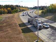
Wayne Gretzky Drive

 | |
|---|---|
| Maintained by | the City of Edmonton |
| Length | 4.8 km (3.0 mi) |
| Location | Edmonton |
| South end | 101 Avenue / 75 Street |
| Major junctions | 106 Avenue, 112 Avenue, 118 Avenue, Fort Road, Yellowhead Trail |
| North end | Fort Road / Yellowhead Trail |

Wayne Gretzky Drive is a freeway in Edmonton, Alberta, Canada. Originally Capilano Drive, it was officially renamed October 1, 1999 after NHL hockey player Wayne Gretzky, as a tribute to his years with the Edmonton Oilers. The same day, Wayne Gretzky's number 99 jersey was retired, at the then Skyreach Centre,[1] which lies just west of Wayne Gretzky Drive, at 118 Avenue.
The freeway portion of Wayne Gretzky Drive was opened in 1969 by widening and connecting the residential streets of 75 Street south of the river, and 72 Street north of the river. It starts as arterial road 75 Street, then changes its name and speed limit at 101 Avenue to become a freeway. It crosses the North Saskatchewan River valley, by passing under 106 Avenue and Ada Boulevard. As it approaches Northlands and the Alberta Avenue area, it again returns into an arterial, with traffic lights. The exits to Northlands at 112 and 116 Avenues are clearly marked with overhead street signs in blue, and with the Northlands logo. Because of property constraints, to maintain the number of lanes, the freeway is divided into Wayne Gretzky Drive Northbound and Southbound, formally 72 and 73 Streets,[2] at 118 Avenue. 119 Avenue services the north Northlands Coliseum parking lot to the west, and is a dead end to the east, because it was blocked off from being used as a shortcut, disrupting traffic flow during major Northlands events. The northbound and southbound then converge again before crossing the LRT lines. Fort Road, which runs to the west, meets up with Wayne Gretzky Drive at an at-grade intersection, then runs concurrently along with it for approximately 180 metres (590 ft) to Yellowhead Trail. The single-point urban interchange at Yellowhead Trail, allows the Yellowhead to run as a freeway, and has the benefit of only one traffic light, and U-turns for westbound and eastbound traffic. At this interchange, Wayne Gretzky Drive changes its name to Fort Road.
Because of their short lengths, Wayne Gretzky Drive and Groat Road will be the only freeways in Edmonton not to have a highway designation, until the completion of Terwillegar Drive.
Neighbourhoods
List of neighbourhoods Wayne Gretzky Drive runs through, in order from south to north:[3]
Bridge structures
A pedestrian bridge flysover Wayne Gretzky Drive at approximately 104 Avenue, connecting the neighbourhoods of Forest Heights and Terrance Heights. 53°32′48″N 113°26′32″W / 53.54667°N 113.44222°W
Capilano Bridge takes Wayne Gretzky Drive over the North Saskatchewan River, spanning 290 metres (950 ft). 53°33′20″N 113°26′19″W / 53.55556°N 113.43861°W
Grant Moellmann Bridge, takes Wayne Gretzky Drive over the LRT tracks and a CN spur that used to service the surrounding industrial area. It was opened in 1995 bridging the gap between 120 Avenue and Fort Road. It is named after Edmontonian ironworker Grant Moellmann (1935–1994) who fell to his death placing the bridge's last girder on November 24, 1994.[4][5] A plaque was placed on the bridge in September 1998 to mark the significance of this naming. 53°34′31″N 113°27′11″W / 53.57528°N 113.45306°W
Interchanges and intersections
Wayne Gretzky Drive currently has five interchanges (bold), giving it freeway status for the 3.4 kilometres (2.1 mi) from 101 Avenue to 116 Avenue, and a maximum speed limit of 80 km/h.[3]
References
- ↑ Edmonton pays tribute to Wayne Gretzky Archived October 4, 2010, at the Wayback Machine.
- ↑ "Community Services Committee Meeting cs1120mn.doc". Edmonton.ca. Retrieved 2014-03-17.
- 1 2 "City of Edmonton map utility". Maps.edmonton.ca. Retrieved 2014-03-17.
- ↑ City of Edmonton, Naming Edmonton : From Ada to Zoie, 2004. ISBN 0-88864-423-X
- ↑ "Workplace deaths 'a dark side of the boom'". Connect2edmonton.ca. Retrieved 2014-03-17.