Lane County, Oregon
| Lane County, Oregon | |
|---|---|
_(lanD0040a).jpg) Lane County Courthouse in Eugene, built in 1898 and demolished in 1959.[1] | |
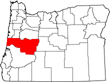 Location in the U.S. state of Oregon | |
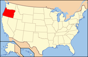 Oregon's location in the U.S. | |
| Founded | January 29, 1851 |
| Seat | Eugene |
| Largest city | Eugene |
| Area | |
| • Total | 4,722 sq mi (12,230 km2) |
| • Land | 4,553 sq mi (11,792 km2) |
| • Water | 169 sq mi (438 km2), 3.6% |
| Population (est.) | |
| • (2015) | 362,895 |
| • Density | 77/sq mi (30/km²) |
| Congressional district | 4th |
| Time zone | Pacific: UTC-8/-7 |
| Website |
www |
Lane County is a county located in the U.S. state of Oregon. As of the 2010 census, the population was 351,715,[2] making it the fourth-most populous county in Oregon. The county seat is Eugene.[3] It is named in honor of Joseph Lane, Oregon's first territorial governor.
Lane County comprises the Eugene, OR Metropolitan Statistical Area. It is the third largest MSA in Oregon, and the 144th largest in the country.[4][5]
History
Lane County was established on January 29, 1851. It was created from the southern part of Linn County and the portion of Benton County east of Umpqua County. It was named after the territory's first governor, Joseph Lane.[6] Originally it covered all of southern Oregon east to the Rocky Mountains and south to the California border. When the Territorial Legislature created Lane County, it did not designate a county seat. In the 1853 election, four sites competed for the designation, of which the "Mulligan donation" received a majority vote; however, since it was contiguous to the "Skinner claim" both became part of the new county seat known as Eugene.
In 1846 Elijah Bristow and his wife, the former Susannah Gabbart, had become the first white settlers to build a claim cabin within the present-day boundaries of Lane County, near Pleasant Hill. They had crossed the plains to California in the previous year, and came north with Eugene F. Skinner, Captain Felix Scott, and William Dodson.[7] As their party entered the valley between the Coast Fork and Middle Fork of the Willamette River, Bristow gazed around and exclaimed, "What a pleasant hill! Here is my home!"[8]
In 1852 John Diamond and William Macy led an exploration party to survey a shortcut for the Oregon Trail across the Cascade Range. The shortcut over the Willamette Pass became known as the Free Emigrant Road. Around 250 wagons with 1,027 people left the usual Oregon Trail route at Vale, Oregon, and followed Elijah Elliott through the central Oregon high desert. This became known as the Elliott Cutoff. When they reached what is now Bend, they sent scouts to the south to look for the road. Once settlers in the Willamette Valley discovered the emigrants were coming, a huge rescue effort was launched as the emigrants were out of supplies and in dire condition. The emigrants of this wagon train doubled the population of Lane County in 1853.[9]
The county has been vastly reduced from its original size by several boundary changes. One of the first changes gave it access to the Pacific Ocean, when it acquired the northern part of Umpqua County in 1853. With the creation of Wasco County in 1854, it lost all of its territory east of the Cascade Mountains. Minor boundary changes occurred with Douglas County in 1852, 1885, 1903, 1915, and 1917; with Linn County in 1907 and with Benton County in 1923.
Geography
According to the U.S. Census Bureau, the county has a total area of 4,722 square miles (12,230 km2), of which 4,553 square miles (11,790 km2) is land and 169 square miles (440 km2) (3.6%) is water.[10] Lane County is one of two Oregon counties that extend from the Pacific Ocean to the Cascades (the other is Douglas County.)[11] A portion of the Umpqua National Forest is in Lane County.
Adjacent counties
- Lincoln County (northwest)
- Benton County (north)
- Linn County (northeast)
- Douglas County (south)
- Deschutes County (east)
- Klamath County (southeast)
National protected areas
- Oregon Islands National Wildlife Refuge (part)
- Siuslaw National Forest (part)
- Umpqua National Forest (part)
- Willamette National Forest (part)
Demographics
| Historical population | |||
|---|---|---|---|
| Census | Pop. | %± | |
| 1860 | 4,780 | — | |
| 1870 | 6,426 | 34.4% | |
| 1880 | 9,411 | 46.5% | |
| 1890 | 15,198 | 61.5% | |
| 1900 | 19,604 | 29.0% | |
| 1910 | 33,783 | 72.3% | |
| 1920 | 36,166 | 7.1% | |
| 1930 | 54,493 | 50.7% | |
| 1940 | 69,096 | 26.8% | |
| 1950 | 125,776 | 82.0% | |
| 1960 | 162,890 | 29.5% | |
| 1970 | 213,358 | 31.0% | |
| 1980 | 275,226 | 29.0% | |
| 1990 | 282,912 | 2.8% | |
| 2000 | 322,959 | 14.2% | |
| 2010 | 351,715 | 8.9% | |
| Est. 2015 | 362,895 | [12] | 3.2% |
| U.S. Decennial Census[13] 1790-1960[14] 1900-1990[15] 1990-2000[16] 2010-2015[2] | |||
2000 census
As of the census[17] of 2000, there were 322,959 people, 130,453 households, and 82,185 families residing in the county. The population density was 71 people per square mile (27/km²). There were 138,946 housing units at an average density of 30 per square mile (12/km²). The racial makeup of the county was 90.64% White, 0.78% Black or African American, 1.13% Native American, 2.00% Asian, 0.19% Pacific Islander, 1.95% from other races, and 3.32% from two or more races. 4.61% of the population were Hispanic or Latino of any race.
There were 130,453 households out of which 28.50% had children under the age of 18 living with them, 48.90% were married couples living together, 10.00% had a female householder with no husband present, and 37.00% were non-families. 26.60% of all households were made up of individuals and 9.10% had someone living alone who was 65 years of age or older. The average household size was 2.42 and the average family size was 2.92.
In the county, the population was spread out with 22.90% under the age of 18, 12.00% from 18 to 24, 27.50% from 25 to 44, 24.40% from 45 to 64, and 13.30% who were 65 years of age or older. The median age was 37 years. For every 100 females there were 96.90 males. For every 100 females age 18 and over, there were 94.70 males.
The median income for a household in the county was $36,942, and the median income for a family was $45,111. Males had a median income of $34,358 versus $25,103 for females. The per capita income for the county was $19,681. About 9.00% of families and 14.40% of the population were below the poverty line, including 16.10% of those under age 18 and 7.50% of those age 65 or over.
2010 census
As of the 2010 United States Census, there were 351,715 people, 145,966 households, and 86,938 families residing in the county.[18] The population density was 77.2 inhabitants per square mile (29.8/km2). There were 156,112 housing units at an average density of 34.3 per square mile (13.2/km2).[19] The racial makeup of the county was 88.3% white, 2.4% Asian, 1.2% American Indian, 1.0% black or African American, 0.2% Pacific islander, 2.8% from other races, and 4.2% from two or more races. Those of Hispanic or Latino origin made up 7.4% of the population.[18] In terms of ancestry, 21.8% were German, 14.9% were English, 13.8% were Irish, and 5.3% were American.[20]
Of the 145,966 households, 26.3% had children under the age of 18 living with them, 44.3% were married couples living together, 10.6% had a female householder with no husband present, 40.4% were non-families, and 28.9% of all households were made up of individuals. The average household size was 2.35 and the average family size was 2.87. The median age was 39.0 years.[18]

The median income for a household in the county was $42,923 and the median income for a family was $55,817. Males had a median income of $43,383 versus $32,745 for females. The per capita income for the county was $23,869. About 10.0% of families and 16.7% of the population were below the poverty line, including 17.1% of those under age 18 and 8.7% of those age 65 or over.[21]
Lane County is the fourth most populous county in Oregon. It grew more slowly from 2000 to 2010 than did the three larger counties, Multnomah (the most populous Oregon county), Washington and Clackamas.[22]
Government
| Year | Republican | Democratic |
|---|---|---|
| 2012 | 36.4% 62,509 | 59.7% 102,652 |
| 2008 | 34.9% 63,835 | 62.4% 114,037 |
| 2004 | 40.4% 75,007 | 58.0% 107,769 |
| 2000 | 40.5% 61,578 | 51.6% 78,583 |
| 1996 | 34.5% 48,253 | 49.7% 69,461 |
| 1992 | 27.5% 41,789 | 48.8% 74,083 |
| 1988 | 39.7% 47,563 | 58.4% 69,883 |
| 1984 | 48.9% 61,493 | 50.9% 63,999 |
| 1980 | 43.6% 54,750 | 41.6% 52,240 |
| 1976 | 42.7% 46,245 | 52.1% 56,479 |
| 1972 | 48.6% 47,739 | 47.0% 46,177 |
| 1968 | 49.1% 39,563 | 42.9% 34,521 |
| 1964 | 32.5% 24,139 | 67.1% 49,785 |
| 1960 | 52.5% 36,148 | 47.3% 32,596 |
Lane County is governed by a County commission. Commissioners are elected officials and serve four-year terms. The current commissioners are:
- Sid Leiken, Springfield
- Jay Bozievich, West Lane
- Faye Stewart, East Lane
- Pete Sorenson, South Eugene
- Pat Farr, North Eugene
Economy
The US Forest Service manages 48% of the lands within the county boundaries. The federal land, which can not be taxed, previously generated hundreds of millions of dollars in logging-derived support for government, but that support was sharply reduced when various environmental regulations curtailed logging by approximately 78%.[23] Although Congress subsequently passed a series of revenue replacing bills culminating in the Secure Rural Schools and Community Self Determination Act of 2000, the federal subsidies have not been adequate to fully replace logging as a means of supporting basic government services.[24] Today, according to the Oregon Criminal Justice Commission Report of 2009, Lane County crime rates are bad and continuing to worsen, but county law enforcement programs and services, from investigation to jail capacity, have been reduced to as little as 15% of state and national average capacity for a jurisdiction of similar size.[25]
Growth in the next decades is predicted to shift away from timber and agriculture to services, manufacturing of transportation equipment, printing and publishing, and high technology. As of July 2008, PeaceHealth Medical Group is the largest private employer in Lane County.[26]
Communities
Incorporated cities
Unincorporated communities
- Ada
- Alma
- Alpha
- Alvadore
- Austa
- Belknap Springs
- Blachly
- Black Butte
- Blue River
- Bohemia City
- Brickerville
- Camp Creek
- Canary
- Cedar Flat
- Cheshire
- Cloverdale
- Crow
- Culp Creek
- Cushman
- Deadwood
- Deerhorn
- Dexter
- Disston
- Divide
- Dorena
- Elmira
- Fall Creek
- Finn Rock
- Flagg
- Franklin
- Gillespie Corners
- Glenada
- Glenwood
- Goldson
- Goshen
- Greenleaf
- Heceta Beach
- Horton
- Indiola
- Inlow
- Jasper
- Lancaster
- Latham
- Leaburg
- Linslaw
- London Springs
- Lorane
- Low Pass
- Luper
- Mabel
- Malabon
- Mapleton
- Marcola
- McCredie Springs
- McKenzie Bridge
- Minerva
- Mohawk
- Natron
- Nimrod
- North Beach
- Noti
- Pleasant Hill
- Rainbow
- Riverview
- Saginaw
- Searose Beach
- Siltcoos
- Swisshome
- Tide
- Tiernan
- Trent
- Triangle Lake
- Unity
- Vaughn
- Vida
- Walden
- Walker
- Walterville
- Walton
- Wendling
- Westlake
- Wildwood
Former communities
- Bethel, now part of Eugene
- Irving, now part of Eugene
- Santa Clara, now part of Eugene
- Thurston, now part of Springfield
See also
- Lane Education Service District
- National Register of Historic Places listings in Lane County, Oregon
References
- ↑ "About Us". Lane County Historical Society. Retrieved 2012-10-30.
Lane County Courthouse, NE corner of 8th Avenue and Oak Street, Eugene; Lane County Jail on left. Lane County Courthouse was built in 1898 and torn down in 1959. — Catalog Number: CS284
- 1 2 "State & County QuickFacts". United States Census Bureau. Retrieved November 15, 2013.
- ↑ "Find a County". National Association of Counties. Archived from the original on 2011-05-31. Retrieved 2011-06-07.
- ↑
- ↑ "OMB Bulletin No. 10-02: Update of Statistical Area Definitions and Guidance on Their Uses" (PDF). United States Office of Management and Budget. December 1, 2009. Retrieved January 18, 2010.
- ↑ Gannett, Henry (1905). The Origin of Certain Place Names in the United States. Government Printing Office. p. 180.
- ↑ Walling, Albert G. (1884). Illustrated History of Lane County Oregon. Lane County, Oregon: Printing house of A. G. Walling. p. 476. ASIN B009QBROJE.
- ↑ Friedman, Ralph (1990). In Search of Western Oregon. Caldwell, Idaho: Caxton Press. p. 707. ISBN 0-87004-332-3.
- ↑ Sullivan, William L. (2002). Thurman, Paula, ed. Exploring Oregon's Wild Areas (3rd ed.). The Mountaineers Books.
- ↑ "2010 Census Gazetteer Files". United States Census Bureau. August 22, 2012. Retrieved February 26, 2015.
- ↑ "About Lane County". Official Lane County web site.
- ↑ "County Totals Dataset: Population, Population Change and Estimated Components of Population Change: April 1, 2010 to July 1, 2015". Retrieved July 2, 2016.
- ↑ "U.S. Decennial Census". United States Census Bureau. Archived from the original on May 11, 2015. Retrieved February 26, 2015.
- ↑ "Historical Census Browser". University of Virginia Library. Retrieved February 26, 2015.
- ↑ Forstall, Richard L., ed. (March 27, 1995). "Population of Counties by Decennial Census: 1900 to 1990". United States Census Bureau. Retrieved February 26, 2015.
- ↑ "Census 2000 PHC-T-4. Ranking Tables for Counties: 1990 and 2000" (PDF). United States Census Bureau. April 2, 2001. Retrieved February 26, 2015.
- ↑ "American FactFinder". United States Census Bureau. Archived from the original on 2013-09-11. Retrieved 2008-01-31.
- 1 2 3 "DP-1 Profile of General Population and Housing Characteristics: 2010 Demographic Profile Data". United States Census Bureau. Retrieved 2016-02-23.
- ↑ "Population, Housing Units, Area, and Density: 2010 - County". United States Census Bureau. Retrieved 2016-02-23.
- ↑ "DP02 SELECTED SOCIAL CHARACTERISTICS IN THE UNITED STATES – 2006-2010 American Community Survey 5-Year Estimates". United States Census Bureau. Retrieved 2016-02-23.
- ↑ "DP03 SELECTED ECONOMIC CHARACTERISTICS – 2006-2010 American Community Survey 5-Year Estimates". United States Census Bureau. Retrieved 2016-02-23.
- ↑ Buri McDonald, Sherri (24 February 2011). "Low-growth pains". The Register-Guard. Retrieved June 2, 2011.
- ↑ "Federal District Court Brings Northwest Timber Sales to a Standstill". The Heartland Institute. December 1, 1999. Retrieved October 12, 2014.
- ↑ Executive Summary Lane County Public Safety Report, http://www.lanecounty.org/cao_pscc/documents/PSTaskForceFinalReportSummary.pdf
- ↑ Schwartz, Susan P. (May 2009). "Lane County Criminal Justice Report" (PDF). State of Oregon Criminal Justice Division. Retrieved October 12, 2014.
- ↑ "Are Lane County's Top 10 employer's hiring?". www.kval.com. January 8, 2009.
External links
 |
Lincoln County, Benton County & Linn County | | ||
| Pacific Ocean | |
Deschutes County | ||
| ||||
| | ||||
| Douglas County | Klamath County |
Coordinates: 43°57′N 122°53′W / 43.95°N 122.88°W