Jhargram
| Jhargram ঝাড়গ্রাম | |
|---|---|
| City | |
|
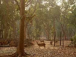
Jhargram Deer Park | |
| Nickname(s): Aranya Sundari | |
 Jhargram Location in West Bengal, India | |
| Coordinates: 22°27′N 86°59′E / 22.45°N 86.98°ECoordinates: 22°27′N 86°59′E / 22.45°N 86.98°E | |
| Country |
|
| State | West Bengal |
| District | Paschim Medinipur |
| Government | |
| • Type | Municipality |
| • Chairperson | Raja Shivendra Bijoy Malla Deb |
| Elevation | 81 m (266 ft) |
| Population (2011) | |
| • Total | 61,712 |
| Languages | |
| • Official | Bengali, English |
| Time zone | IST (UTC+5:30) |
| PIN | 721507 |
| Telephone code | 03221 |
| Vehicle registration | WB-33,34,50 |
| Lok Sabha constituency | Jhargram |
| Vidhan Sabha constituency | Jhargram, Gopiballavpur |
| Website |
www |
Jhargram (Bengali: ঝাড়গ্রাম) is a subdivisional municipality in the Jhargram subdivision of Paschim Medinipur district in the Indian state of West Bengal.It is an important city in Paschim Medinipur district of West Bengal, India. It is multi-cultural and cosmopolitan city. Jhargram is famous for its wooded beauty and topography culminating in the hill ranges of Belpahari, Kankrajhor to the north and Subarnarekha to the south. It is a favorite destination for people who love forests. The ancient temples, royal palaces, and folk tunes and rhythms make this area attractive.[3] The West Bengal Government is planning to establish Jhargram as an independent district.[2]
Geography
Jhargram is located at 22°27′N 86°59′E / 22.45°N 86.98°E.[4] It has an average elevation of 81 metres (265 feet). The weather, like much of Bengal, is extremely humid and tropical. Temperatures can reach as high as 46 °C in the hot and dry months of May and June but can plummet to 4 °C in the chilly nights of December and January.
History
Legend says that around 1592 CE, Raja Man Singh of Amber had come to conquer Bengal on behest of Mughal Emperor Akbar the Great from Rajputana (Rajasthan) to expand the Mughal Empire to Eastern India. He appointed one of his loyal officers in the army, Sarveshwar Singh, to defeat the local rulers of the region known as Junglekhand. This area is also mentioned in Ain-i-Akbari as Jharikhanda, and it was populated by the Santhal, Munda, Bhumij and Lodha people groups. The area belonged to the Mal Raja. The Mals were ancient warriors and were powerful people in the eastern part of India since the time of the Mauryas and the Guptas.
Sarveshwar Singh, together with the Rajput military force and cavalry, invaded the deep forest and vanquished the Mal rulers. Hence, he adopted the surname, Malla Deb. In order to commemorate this victory, every year an idol of Mal Raja is made and slain on Vijayadashami day. Raja Man Singh was appointed the Governor of Bengal, Bihar, and Orissa by the Mughal Emperor. After the campaign, he decided to return to Rajputana and granted Mansabdari of the 1200 km square Junglekhand region to Sarveshwar Singh as a reward.
The first fortress was supposed to have existed in Old Jhargram, but the ruins of the fortress are said to have gone underground due to some unknown reasons. Sarveshwar Singh was the founder of the Jhargram kingdom, and he belonged to the Chauhan clan of Rajputs from Fatehpur Sikri in Rajputana.[5] He took the title of Raja and named the state capital Jhargram, which means a forest village which is surrounded by walls and canals. It was known as Ugal in the local language. Even today, the day after Durga Ashtami, the four corners (Ugals) are worshiped for the protection of the erstwhile kingdom. The man who was the hero or bull within the surrounded wall and canal were called Ugal Sanda. As such, the full name of the Raja of the State was known as Raja Sarveshwar Malla Ugal Sanda Deb, and the title has been continued up to Raja Narasingha Malla Ugal Sanda Deb.
The Marathas invaded the region between 1742–47. The rulers of Jhargram joined forces with Raja of Bishnupur and the Nawab of Bengal to fight a war against them, and they were victorious. Jhargram remained an independent kingdom until 1767, when The East India Company, led by Robert Clive, came from Midnapore, via Radhanagar to capture the Jhargram fort. Raja took part in the Chuar Rebellion to protect his independent status and revolted against the British, but he ultimately surrendered. The kingdom was then recognized as a Zamindari estate under the law of primogeniture, and the ruler was given the title of Raja. Jhargram fell twice into the Court of Wards, after the death of Raja Raghunath Malla Ugal Sanda Deb and Raja Chandi Charan Malla Ugal Sanda Deb, respectively; but was later released when the Raja Narasingha Malla Deb attained majority. In this connection, it may be mentioned that in 1944–45, the then Vice-Roy of India agreed to recognize Jhargram as a feudatory state; but at that time, the whole of India was going through turmoil and was moving towards independence. The Cabinet mission came to negotiate with congress, the Muslim League, and other parties. The proposal for the feudatory status of Jhargram Raj has put aside then.
The rulers of Jhargram were benevolent and progressive, and they focused on the welfare of their subjects. Raja Raghunath Malla Deb studied FA in Scottish Church College, and was the first-degree holder in the district. In 1899, he had established the first primary school in his kingdom. Raja was also an avid wrestler and was known for miraculous physical strength. His wrestling instruments are still kept in the Palace and Calcutta Museum. Raja Sir Narasingha Malla Deb, the last titular king of Jhargram, is considered the father of modern Jhargram. Educated at Midnapore Collegiate School and Presidency College in Calcutta, he is conferred with OBE and KBE, granted the King George V Silver Jubilee Medal, served as a member of the Legislative Council of Bengal from 1947–52 and 1952–57, and also a member of Parliament-Lok Sabha in Congress from 1957-62. He commissioned the new palace in 1931, which is one of the finest example of Indo Saracenic architecture and spread over 23 acres of land. During World War II, Raja sahib constructed an airstrip in Dudhkundi for the United States Air Force, apart also provided the Allied forces with elephants, vehicles and other help.
Between 1922–1950 Prof. Debendra Mohan Battacharya was the administrator of Jhargram and that time is seen as a golden age. In those twenty-eight years, Jhargram developed into a township; and during this period, many educational institutions were established and developed. Kumud Kumari Institution (K.K.I), a premier institution of the sub-division, was founded in 1924. In 1925, an annual sports fund was created; which was to be used to encourage sports activities, and construct the football stadium and the Jhargram Club. Raja Narasingha Malla Deb established Jhargram Agricultural College, which was renamed Jhargram Raj College. He also established Vidyasagar Polytechnic, industrial training and gave funds to set up Sri Ramkrishna Saradapeeth Girls High School and Bharat Sevashram Sangha. The royal family established and assisted in the running of all primary institutions for at risk people in the Jhargram estate. At the consent of the Governor of Bengal, he established a hospital at Jhargram town in the name of his late father, Chandi Charan Charitable Hospital. Later on in every tehsil, a charitable hospital was established for primary treatment in the nearby villages. Raja established the Bani Bhaban, under the guidance of Lady Abala Bose, for rehabilitation of widows. He also donated land to the Roman Catholic Church of India and the Muslim community to build Nurrani Jama Masjid in Jhargram. In 1947, further land was acquired, and Jhargram Raj constructed buildings to develop a school, which was Rani Binode Manjuri Govt. Girls School; which is now one of the premier schools in Midnapore district.
Between 1928–1950, Sir Raja Narasingha Malla Deb donated to welfare causes and donated 10,000 bighas of land to poor farmers in 1947, making him the single largest land donor in West Bengal. [6]
Jhargram Forest
For scientific management of forests vested in Government under Estate Acquisition Act, 1953, Jhargram Forest under the administrative setup as Jhargram Division erstwhile parent division styled as Midnapur Division was bifurcated into two divisions viz. West Midnapur Division (renamed as Jhargram Division ) with headquarters at Jhargram and East Midnapur Division with headquarters at Midnapur. The West Midnapore Division came into existence on 29.01.1954.
Location
Presently the forests of Jhargram Division are situated in the Civil Sub-division of Jhargram of Paschim Medinipur District and cover the Civil Blocks viz. Binpur-I (the portion on the West of the Kangsabati river), Binpur-II, Jhargram, Jamboni, Gopiballavpur-I & Gopiballavpur-II and police stations of Belpahari, Binpur, Jamboni, Jhargram, Gopiballavpurand Beliyabera. The Jhargram Forest Division lies between 21°-52' and 22°-48' North latitudes and 86°-34' and 87°-20' East longitude approximately. On the North, it is bordered by the civil districts of Purulia and Bankura and on the East, it is bordered by the river Kangsabati (from the western border of Midnapore Division) and partly by the river Subarnarekha from the western border of Kharagpur Division. It is having common borders with the State of Orissa on the Southand in the West with the Jharkhand State.
The headquarters of this Division is Jhargram which is around 15 km away from the National Highway-6 (popularly known as Bombay Road) and is situated on the Kolkata-Bombay main line of the South-Eastern Railway. The town is also the headquarters of Jhargram sub-division. The distance of Jhargram from Kolkata is approximately 200 km.
Drainage
The important rivers of this division are the Kangsabati (popularly known as Kasai), the Tarafeni, the Subarnarekha and the Dulong. Apart from the above rivers, there are several rivulets viz. 'Deb', 'Palpala', Rangium', 'Kupon' etc. Most of the above rivers flow from west to east as the Western side of the division is having higher altitude.
Rivers of Jhargram Division
The Kangsabati river
This river enters the division on the north from Bankura district and flows along a tortuous course running to the south and southwest direction and then flows towards east keeping the Midnapore town on the left(north). The river has contracted rapidly below Midnapore and at Kapastikri (about 20 km down below from Midnapore) the river has bifurcated. One course has gone towards the north and finally has drained into the Rupnarayan river while the other course has run towards the south-east and finally has fallen into the Haldi river.
The Tarafeni river
This river originates in the northwest portion of this division near Patagarh in Banspahari Range. It runs towards east within the jurisdiction of Belpahari and Binpur police Stations and finally has fallen into the Kangsabati river.
The Subarnarekha river
This river enters the division on the west from Dhalbhum (Jharkhand State) and passes through the south of the division intersecting the Gopiballavpur Police Station and forming the northern boundary of Nayagram Police Station (Kharagpur Division). On the south of Dantan, it enters the Balasore district of Orissa and finally falls into the Bay of Bengal. The Subarnarekha has a rapid stream with a sandy bed, and its banks are generally high and well defined. In the season of high flood, the river overflows its left bank about 6 km above the point where it leaves Paschim Midnapore district to enter the Balasore district.
The Dulung river
It is the main tributary of the Subarnarekha. It originates in the northwest portion of the division near Dulungdiha (J.L.No. 100, P.S. : Binpur) and runs generally in a southern direction near the western boundary of the division till it enters Jamboni Police Station. While passing through this police station from north to south it is joined by the Kupon river, Bashi Khal, Polpala Khal, Deb river and Putrangi Khal. Thereafter, it enters Gopiballavpur Police Station where its general direction is from west to east and then Sankrail police station where it again runs in a southernly direction and joins the Subarnarekha.
Rainfall
The average annual rainfall of Jhargram (Jhargram Forest Division) is about 1400 mm. The rainy season spreads over June to September due to southwest monsoon and highest rainfall occurs in July and August. The rainfall starts decreasing from October and dry winter sets in. The dry season lasts until May. However, during this time this division gets some sporadic showers.
| Climate data for Jhargram, India | |||||||||||||
|---|---|---|---|---|---|---|---|---|---|---|---|---|---|
| Month | Jan | Feb | Mar | Apr | May | Jun | Jul | Aug | Sep | Oct | Nov | Dec | Year |
| Average high °C (°F) | 16 (61) |
21 (70) |
32 (90) |
38 (100) |
39 (102) |
36 (97) |
30 (86) |
30 (86) |
30 (86) |
31 (88) |
19 (66) |
17 (63) |
30 (86) |
| Average low °C (°F) | 5 (41) |
10 (50) |
21 (70) |
25 (77) |
27 (81) |
27 (81) |
23 (73) |
23 (73) |
22 (72) |
21 (70) |
7 (45) |
6 (43) |
22 (72) |
| Average precipitation mm (inches) | 9.8 (0.386) |
8.3 (0.327) |
19.4 (0.764) |
57.7 (2.272) |
74.9 (2.949) |
172.8 (6.803) |
334.9 (13.185) |
332.7 (13.098) |
185.8 (7.315) |
104.5 (4.114) |
8.7 (0.343) |
5.9 (0.232) |
1,007.4 (39.661) |
| Source: Weatherbase[7] | |||||||||||||
Altitude
The general ground configuration is having gentle slope towards the east. Hilly terrain occurs in the north-western portion of the Division. Kankrajhore area is having the highest altitude of around 300 m and Gopiballavpur is having the lowest altitude of around 65 m The altitude of Jhargram town is around 80m. There are local variations in the slopes of the land within the division.
History of the division
In southwest Bengal (including the forests of erstwhile West Midnapore Division), history of forest and its management can be traced to the 16th century when forests were free for use by local villagers for household purposes and cleaning for cultivation. During Mughal Period under land revenue system introduced by Todar Mal, local Zamindars had to pay "RUBA" or ¼ th share of revenue to Mughal Emperors for the protection being given by them.In 1773 East India Company went for the permanent settlement of forests ( and the landed properties) with Zamindars as Proprietor. During 1890-1905 Bengal-Nagpur Railways opened railway lines (which helped the transport of forest produces to far off places with ease and less cost) and this followed by two world wars took a heavy toll of forest resources.
The forests of this division were included in Jungle Mahal which was held by Zamindars (local chiefs) who maintained their respective forests in a feudal tenure system. With the coming up of Bengal-Nagpur Railway lines from Kharagpur to Jamshedpur Via Jhargram, the forests of this area became accessible. The value of forest produces suddenly increased as they could be transported to far off places by rail with less cost and in quick time. The forests came to be recognized as a source of earning a higher return to the Zamindars. The forests of this division were mostly owned by the Nawab of Murshidabad, the Raja of Mayurbhanj, the Raja of Jhargram, the Raja of Chilkigarh and the Mindapore Zamindar company etc.. The forests were in advanced stage of degradation brought about by ruthless exploitation by the Zamindars on a rotation of 4–5 years. This system of management (mismanagement) of forests continued till 1948 when the Govt. of West Bengal started exercising control over the management of forests under the West Bengal Private Forests Act, 1948. But the situation did not improve much.
In 1953 Estates Acquisition Act came into force and the forests so long owned by private owners (big Zamindars) were vested to the government since 1954-55 and afterward were free from all encumbrances for scientific management and control. Subsequently, possession of the forests was being taken by the Forest Department gradually depending upon the availability of records, evidence, and Court's Orders.
After the State (Govt.) took over, the forests were brought under scientific management. However, by this time, the productivity of the forests had gone down to such a level that they could not meet the growing demands of forest produces from ever-increasing population of fringe areas and the country as a whole. The problem was further multiplied due to growing unemployment in the forest fringe villagers and lack of enough resources in the rural areas to tide over the situation.
Administrative measures and policing efforts to thwart the biotic pressures on the forests only resulted in increased people-forester conflict and led to complete alienation of the fringe population from the administration. The job of protection of forests became hazardous. The administration had almost failed to tackle the situation and had been looking for some solution.
A pilot project was launched in 1971-72 by the then Divisional Forest Officer, Silviculture(South) Division at Arabari of East Midnapore Division. The objective was to involve the people living on the fringes of forests, in protecting forest resources through improvement of their socio-economic condition.
During 1985-86 the pilot project was reviewed, evaluated and analyzed. It appeared that the entire project area had become restocked with nearly 700 ha of beautiful sal coppice forests and 300 ha of plantation crop. In fact, this pilot project proved to be a success.
This formula of involvement of indigenous people in forest protection and management was translated in other areas including West Midnapore Division since mid-eighties very successfully. Govt. gave recognition to this system of management of forests (popularly termed as Joint Forest Management) by issuing a Govt. Order during 1989 and amendments during 1990 and 1991. Presently this division is having nearly 480 Forest Protection Committees. On and from 1 April 2006 the West Midnapore Division has been reorganized and renamed as Jhargram Forest Division. 3 (three) Ranges namely Chandabila, Nayagram and Kesorekha Ranges have been transferred to Kharagpur Division with all establishments. Therefore, the area of Jhargram Division becomes 620 km2 approximately.
Demographics
As of 2001 India census,[8] Jhargram had a population of 53,158. Males constitute 51% of the population and females 49%. Jhargram has an average literacy rate of 76%, higher than the national average of 59.5%: male literacy is 82%, and female literacy is 71%. In Jhargram, 11% of the population is under 6 years of age.
Police station
Jhargram police station has jurisdiction over Jhargram CD Block.[9][10]
Economy
The main economy of this area is cultivation, business. Some people are government employees, School Teachers and employed in other small private sectors.The financial status of most of the people is in the middle class category.
Transportation
Air
Nearest airport is Chakulia Airfield, at about 39 Km distance. It was last used during WW2 upto 1945. The nearest operational airport is Netaji Subhash Chandra Bose International Airport of Kolkata 155 km (by train) and 169 km (by road- NH-6).Sonari Airport of Jamshedpur is located at a distance 96 km by train.Birsa Munda Airport of Ranchi is located at a distance of 233 km (by road- NH-33) and 258 km (by train).
Train
Jhargram is connected not only to larger cities in the region, but also to smaller towns and villages in the district. Jhargram Railway Station is on the Kharagpur-Tatanagar section of Howrah-Nagpur-Mumbai line, an express train route. The Jhargram railway station comes under South Eastern Railway. Jhargram is well connected by train to nearest big city like Kolkata/Howrah (155 km), Kharagpur (39 km), Asansol, Tatanagar (96 km), Ranchi, Dhanbad, Rourkela, Jharsuguda, Bhubaneswar, Cuttack, Puri, Bhilai and also Delhi, Mumbai etc.
Bus
Jhargram is also very well connected by roads/highways with other nearby cities like Medinipur (40 km over Dherua - Medinipur Road), Kharagpur (46 km over NH-6), Durgapur (156 km over SH-9), Asansol (181 km over NH-60 and SH-9), Bankura (114 km over SH-9 and 5), Purulia (142 km over SH-5), Haldia (150 km over NH-6 and 41), Contai (144 km over SH-5), Digha (165 km over NH-60), Kolkata/Howrah (169 km over NH-6), Tatanagar (114 km over NH-33), Baripada (99 km over NH-6 and NH-5), etc.
Local Transportation
For local transportation Bus, Taxi, Minibus, Auto-Rikshaws, Cycle-Rikshaws, Electric-Rikshaws (ToTo) are available.
Education
There are a number of well-known schools and colleges in Jhargram.
Colleges
The name of the colleges are
- Jhargram Raj College (Govt. College) under Vidyasagar University.
- Industrial Training Institute (ITI), Jhargram.
- Vivekananda Satavarshiki Mahavidyalaya - Govt. College
- I.C.V Polytechnic,Jhargram-Govt. Engineering College under WBSCTE
Schools
Schools in Jhargram follow the "10+2+3" plan. After completing their secondary education, students typically enroll in schools that have a higher secondary facility and is affiliated with the West Bengal Council of Higher Secondary Education.
The name of the schools are
- Jhargram Kumud Kumari Institution established in 1924, is one of the oldest institutions.
- Rani Benode Manjari Govt Girls School (H.S)
- Sri Ramkrishna Saradapeeth Kanya Gurukul (1st girls' school in Jhargram)
- Jhargram Nanibala Vidyalaya
- Jhargra Banitirtha High School
- Dahijuri Mahatma Vidyapith
- Ekalavya Residential School
- Jhargram Asoke Vidyapith(H.S.)
- West End High School -ICSC Board (Delhi)
- C.F. Andrews Memorial School- not affiliated
- Bikash Bharati Blooms Day School - CBSE Board
Culture
Jhargram is the golden treasury of tribal dances. Some of these tribal dances are on the verge of extinction. Chuang, Chang, Chou, Dangrey, Jhumur, Panta, Ranpa, Saharul, Tusu & Bhadu etc. is not only a mere experience of some masterpiece of human creative art, but a fascinating adventure through essential dimensions of a civilization, its collective priorities, the skills of their implementation and the philosophies that inform them.
Besides the tribal culture, the regular Bengali festivals like Durga puja, Saraswati puja, Diwali and Kali pujas are well attended. Other common pujas in the worship of Sitala, Jagaddhatri, Holi, Ratha Yatra, Janmashtami, Bheema Puja, etc. also takes place.
To know more details about tribal dances and cultures see
A lot of fairs and carnivals take place in Jhargram. The famous fairs in Jhargram are Jungle Mahal Utsav, Jhargram Mela & Yuva Utsav, Rong Maati Manush, Shrabani Mela, Baishakhi Mela, Milan Mela.[11]
Tourist Attractions
Jhargram is a interesting tourist place for its unique location and natural beauty. There are several tourist-attracting places throughout the Sub-Division.
- Jhargram Palace
- Deer Park
- Savitri Temple
- Rabindra Park
- Chilkigarh Raj Palace
- Kanak Durga Temple
- Jungle Mahal
- Medical Plants Garden (Kalaboni)
- Dherua (for the banks of Kansai river)
- Sevayatan is known for its beauty of Kechenda Bandh (lake) & surrounding forests.
- Tribal Museum
- Alampur
- Kendua (to see migrating birds)
- Kakrajhore Forest
- Rohini: This is a historical village situated on the bank of Subarnarekha River. Birthplace of famous Vaishnav saint Rashikanandaji Maharaj.
- Mukutmanipur Dam
- Gidhni Annukul Ashram
- Pukuria Bharat Sevashram Sangha
References[12]
- ↑ "R.B.M.Govt. Girls High School - Wikimapia". wikimapia.org. Retrieved 2016-11-04.
- 1 2 "Jhargram and Asansol to be new districts".
- ↑ https://www.paschimmedinipur.gov.in/tourism/index.php
- ↑ "Maps, Weather, and Airports for Jhargram, India". Retrieved 25 August 2016.
- ↑ Rathore, Abhinay. "Jhargram (Zamindari)". Retrieved 25 August 2016.
- ↑ "Jhargram Estate". WordPress.com. May 19, 2014. Retrieved December 1, 2014.,
- ↑ "Weatherbase: Historical Weather for Jhargram, India". Weatherbase. Retrieved 1 April 2010.
- ↑ "Census of India 2001: Data from the 2001 Census, including cities, villages and towns (Provisional)". Census Commission of India. Archived from the original on 2004-06-16. Retrieved 2008-11-01.
- ↑ "District Statistical Handbook 2014 Paschim Medinipur". Tables 2.1, 2.2. Department of Statistics and Programme Implementation, Government of West Bengal. Retrieved 20 November 2016.
- ↑ "District at a Glance". Paschim Medinipur District Police. Retrieved 20 November 2016.
- ↑ "Jhargram Pincode". citypincode.in. Retrieved 2014-05-19.
- ↑ "Ashoka Hotel & Lodge". Justdial. Retrieved 2016-11-04.
External links
![]() Jhargram travel guide from Wikivoyage
Jhargram travel guide from Wikivoyage
- Jhargram Holidays (Official Website) [ welcome to Jangalmahal ]
- Jhargram (Non Profitable Official Website)
- Jhargram Municipality (Official Website)
Cities, towns and locations in Paschim Medinipur District | |||||||||||||||
|---|---|---|---|---|---|---|---|---|---|---|---|---|---|---|---|
| Cities, municipal and census towns |
| ||||||||||||||
| Locations other than cities and towns |
| ||||||||||||||
| Related topics |
| ||||||||||||||