Nadia district
| Nadia district নদিয়া জেলা | |
|---|---|
| District of West Bengal | |
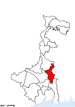 Location of Nadia district in West Bengal | |
| Country | India |
| State | West Bengal |
| Administrative division | Presidency |
| Headquarters | Krishnanagar, Nadia |
| Government | |
| • Lok Sabha constituencies | Krishnanagar, Ranaghat Some of area covered with Bangaon |
| • Assembly seats | Karimpur, Tehatta, Palashipara, Kaliganj, Nakashipara, Chapra, Krishnanagar Uttar, Nabadwip, Krishnanagar Dakshin, Santipur, Ranaghat Uttar Paschim, Krishnaganj, Ranaghat Uttar Purba, Ranaghat Dakshin, Chakdaha, Kalyani, Haringhata |
| Area | |
| • Total | 3,927 km2 (1,516 sq mi) |
| Population (2011) | |
| • Total | 5,168,488 |
| • Density | 1,300/km2 (3,400/sq mi) |
| • Urban | 979,519 |
| Demographics | |
| • Literacy | 75.58 per cent[1] |
| • Sex ratio | 947 |
| Major highways | NH 34 |
| Website | Official website |
Nadia district (Pron: nɔd̪iːaː) (Bengali: নদিয়া জেলা) is a district of the state of West Bengal, in eastern India. It borders Bangladesh to the east, North 24 Parganas and Hooghly districts to the south, Bardhaman to the west, and Murshidabad to the north.
History
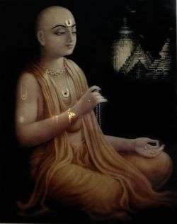
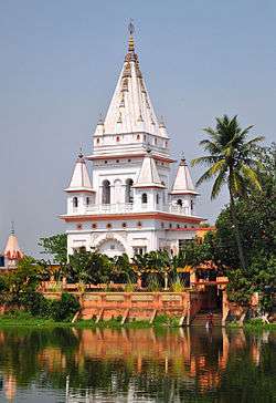
Nabadwip♢, a town in Nadia district, is often referred to as “Oxford of Bengal”.[2] Chaitanya Mahaprabhu (b.1486–d.1534) was born in Nabadwip. One of the Indian schools of logic (tarkashastra) called Navya Nyaya system was developed in Nabadwip, which produced great logicians in the 15th century Nabadwip was an important seat of political power in Bengal under Ballal Sen and later Lakshman Sen, kings of the Sena Empire, who ruled from 1159 to 1206.[3] In 1202, Nabadwip was captured by Bakhtiyar Khilji. This victory paved the way for Muslim rule in Bengal.[4] Nabadwip and some other places in Nadia were centres of learning and intellectual prowess. . It was the place where Lord Chaitanya Mahaprabhu, a major Hindu saint, was born and lived. The religious atmosphere of Nabadwip is a combination of Vaishnava, Shakta, Buddhist, Shaiva. The main festival of Nabadwip is "Rash Utsab" (Rasa lila). It is also known as "Pat Purnima" or "Rash Kali Puja" or "Shakta Rash". The varieties of Baishnaba, Shakta, Saiba Pratima (Idols) attracts every one.
Geography
Important towns
Krishnanagar is the district headquarters of Nadia. It is located on the bank of river Jalangi. Krishnanagar is named after Raja Krishna Chandra Rai (1728–1782).
Nabadwip was the capital of Bengal under Ballal Sen and later Lakshman Sen, the famous rulers of the Sena Empire, who ruled from 1159 to 1206.[3]
Kalyani is another important city and only smart city of this district. It was identified (and named) by B. C. Roy to act as an alternative to the city of Kolkata, from which it is about 50 km away. Kalyani also known of education hub & medical hub in this district.
Ranaghat, situated 74 kilometres north of Kolkata, is famous for its railway communication.
Santipur is a very popular city in Nadia district. This small town has been declared a city recently. The fort area of this city, also known as Daak-Gharh (calling or gathering room) is thought to have been built by Raja Krishnachandra of Nadia.
Chakdaha is also an important town of this district.
Birnagar is also an important town and oldest municipality of this district. Kabi Nabin Chandra Sen, Kabi Rajshekhar Basu and Bhakti Vinod Thakur are famous person of Birnagar area.
Badkulla is also an important city of this district situated at a distance of 10 kilometres from district headquarters Krishnagar.
Bethuadahari is an important town of this district.This place is very much famous for Bethuadahari Wildlife Sanctuary.
Tehatta is another important subdivisional town. It is the newest subdivision in the district of Nadia.
Shimurali is also an important city of Nadia district.it has renowned for its cleanness and simplicity,and it has 150 year old temple.and a government b,Ed colllegecollege.
Important Villages
It has been reported that the following list of Villages are in Nadia District[5]
- <Khhounishnagar>
- Charpanpara
- Panpur 741249
- Phulia (Which is famous for Tangail Saree)
- Hanskhali
- Taherpur
- Bahirgachhi Halt
- Cheuria
- Debagram
- Dhubulia
- Muragacha
- Hansadanga-Banagram
- Bhaktanagar
- Anandanagar
- Haronagar
- Paninala
- Chougachha
- Bahadurpur
- Bishnunagar
- Mayapur
- Belpukur
- Chapra
- Bangaljhii
- Chapra-Nabinngar
- Harinarayanpur
- Uttar Bahirgachhi
- Parkula
- Choto Shimulia
- Dolimula
- Srikrishnapur
- Dayal Nagar
- Eralbahadurpur
- Ghoshpara (presently, a neighbourhood of Kalyani city)
- Nagarukhra (Kalyani Sub-Division)
- Kutabpur
- Nabadwip Ghat
- Suvarnapur
- Chhoto Chupria
- Chakbehari [Tehatta 2]
- Chanduria
- Rautari
- Chanduria ghat
- Poragachha
- Kulgachi
- Asannagar
- Bhimpur
- Majdia
- Bagula
- Mayurhat
- Dignagar
- Nawpara
- Suvashnagar
- pratapnagar
- Mrigi
- bilkumari
- Karimpur
- dattapulia
- Barbaria
- payradanga
- Haradham
- Madanpur
- Palsunda
- Bamunpukur
- Molla Para
- Panikhali Bazer
- Matiara
- Bhaluka 741317
- Bhairab Chandra pur
- Roy Pur
- Hudachapra
- Tarinipur
- Jalalkhali
- Badkulla
- Ruppur-741238
Divisions
Administrative subdivisions
The district comprises four subdivisions: Krishnanagar Sadar, Kalyani, Ranaghat and Tehatta. Krishnanagar Sadar subdivision consists of Krishnanagar municipality, Nabadwip municipality and seven community development blocks: Kaliganj, Nakashipara, Chapra, Krishnanagar–I, Krishnanagar–II, Nabadwip and Krishnaganj. Kalyani subdivision consists of Chakdaha municipality, Gayespur municipality, Kalyani municipality and two community development blocks: Chakdaha and Haringhata. Ranaghat subdivision consists of Shantipur municipality, Ranaghat municipality, Birnagar municipality and four community development blocks: Hanskhali, Shantipur, Ranaghat–I and Ranaghat–II. Tehatta subdivision consists of four community development blocks: Karimpur–I, Karimpur–II, Tehatta–I and Tehatta–II.[6] Krishnanagar is the district headquarters. There are 19 police stations, 17 development blocks, 8 municipalities, 187 gram panchayats and 2639 villages in this district.[6][7]
Other than municipality area, each subdivision contains community development blocks which in turn are divided into rural areas and census towns. In total there are 29 urban units: 8 municipalities and 15 census towns and two notified areas.[8] Ranaghat, Aistala, Satigachha, Nasra and Cooper's Camp together forms Ranaghat urban agglomeration. Nabadwip, Char Maijdia and Char Brahmanagar forms Nabadwip UA. Chakdaha, Gopalpur and Parbbatipur forms Chakdaha UA. Krishnanagar and Baruihuda together forms Krishnanagar UA. Birnagar, Phulia and Taherpur together forms Birnagar UA.
Krishnanagar Sadar Subdivision
- Krishnanagar: municipality
- Nabadwip: municipality
- Kaliganj (Community development block) consists of rural areas only with 15 gram panchayats.
- Nakashipara (Community development block) consists of rural areas with 15 gram panchayats and two census town: Jagadanandapur and Kshidirpur.
- Chapra, Nadia (Community development block) consists of rural areas with only 13 gram panchayats.
- Krishnanagar I (Community development block) consists of rural areas with 12 gram panchayats and one census town: Baruihuda.
- Krishnanagar II (Community development block) consists of rural areas only with 7 gram panchayats.
- Nabadwip (Community development block) consists of rural areas with 8 gram panchayats and three census towns: Bablari Dewanganj, Char Maijdia and Char Brahmanagar.
- Krishnaganj (Community development block) consists of rural areas only with 7 gram panchayats.
Kalyani subdivision
- Chakdaha: municipality
- Kalyani: municipality
- Gayespur: municipality
- Haringhata: municipality
- Chakdaha (Community development block) consists of rural areas with 17 gram panchayats and two census towns: Darappur and Madanpur.
- Haringhata (Community development block) consists of rural areas only with 10 gram panchayats and two census towns: Haringhata and Nagarukhra.
Ranaghat subdivision
- Shantipur: municipality
- Ranaghat: municipality
- Birnagar: municipality
- Taherpur: municipality
- Cooper's Camp: municipality
- Badkulla: municipality
- Hanskhali (Community development block) consists of rural areas only with 13 gram panchayats.
- Santipur (Community development block) consists of rural areas with 10 gram panchayats and one census town, Phulia.
- Ranaghat I (Community development block) consists of rural areas with 10 gram panchayats and four census towns: Aistala, Satigachha, Gopalpur and Parbbatipur
- Ranaghat II (Community development block) consists of rural areas with 14 gram panchayats and one census town: Nasra
Tehatta subdivision
- Karimpur I (Community development block) consists of rural areas with 8 gram panchayats and one census town: Karimpur.
- Karimpur II (Community development block) consists of rural areas only with 10 gram panchayats.
- Tehatta I (Community development block) consists of rural areas only with 11 gram panchayats.
- Tehatta II (Community development block) consists of rural areas only with 7 gram panchayats.
Santipur is about 16 km from Krishnanagar, the headquarters of Nadia District, in West Bengal. The place has a prominent place in the history of Bengali literature. It is famous as the birthplace of Krittibas, who first translated the epic Ramayana from Sanskrit to Bengali in verses.
The residence of Krittibas is now converted into Krittibas Memorial Community Hall cum Museum Library. Adjacent to this is a Gofa, the place of worship of Thakur Haridas.
The Ganges River flows close to the town. Santipur is also famous for producing Tangail Saree and Raas Utsaab.
The town of Plassey has a memorial of the Battle of Plassey , which took place on 23 June 1757, on the riverbanks of the Bhagirathi River, about 150 km north of Calcutta, near Murshidabad, then the capital of the Nawab of Bengal. marking a decisive victory for the British East India Company over Siraj Ud Daulah, the last independent Nawab of Bengal and his French allies.
Assembly constituencies
The district is divided into 15 assembly constituencies:[9]
- Karimpur (assembly constituency no. 77),
- Tehatta (assembly constituency no. 78),
- Palashipara (assembly constituency no. 79),
- Kaliganj (assembly constituency no. 80),
- Nakshipara (assembly constituency no. 81),
- Chapra (assembly constituency no. 82),
- Krishnanagar Uttar (assembly constituency no. 83),
- Nabadwip (assembly constituency no. 84),
- Krishnanagar Dakshin (assembly constituency no. 85),
- Santipur (assembly constituency no. 86),
- Ranaghat Uttar Paschim (assembly constituency no. 87),
- Krishnaganj (SC) (assembly constituency no. 88),
- Ranaghat Uttar Purba (SC) (assembly constituency no. 89),
- Ranaghat Dakshin (SC) (assembly constituency no. 90),
- Chakdaha (assembly constituency no. 91),
- Kalyani (SC) (assembly constituency no. 92) and
- Haringhata (SC) (assembly constituency no. 93).
Krishnaganj, Ranaghat Dakshin, Kalyani, Haringhata, Ranaghat Uttar Purba and Kaliganj constituencies are reserved for Scheduled Castes (SC) candidates. Along with six assembly constituencies from Murshidabad district, Karimpur assembly constituency forms the Murshidabad (Lok Sabha constituency). Palashipara, Nakashipara, Kaliganj, Chapra, Krishnaganj, Krishnanagar East and Krishnanagar West constituencies form the Krishnagar (Lok Sabha constituency). Nabadwip, Shantipur, Hanskhali, Ranaghat East, Ranaghat West, Chakdaha and Haringhata assembly constituencies form the Nabadwip (Lok Sabha constituency), which is reserved for Scheduled Castes (SC) candidates.
Constituencies
Impact of delimitation of constituencies
As per order of the Delimitation Commission in respect of the delimitation of constituencies in the West Bengal, the district will be divided into 17 assembly constituencies:[10]
- Karimpur (assembly constituency no. 77),
- Tehatta (assembly constituency no. 78),
- Palashipara (assembly constituency no. 79),
- Kaliganj (assembly constituency no. 80),
- Nakshipara (assembly constituency no. 81),
- Chapra (assembly constituency no. 82),
- Krishnanagar Uttar (assembly constituency no. 83),
- Nabadwip (assembly constituency no. 84),
- Krishnanagar Dakshin (assembly constituency no. 85),
- Santipur (assembly constituency no. 86),
- Ranaghat Uttar Paschim (assembly constituency no. 87),
- Krishnaganj (SC) (assembly constituency no. 88),
- Ranaghat Uttar Purba (SC) (assembly constituency no. 89),
- Ranaghat Dakshin (SC) (assembly constituency no. 90),
- Chakdaha (assembly constituency no. 91),
- Kalyani (SC) (assembly constituency no. 92) and
- Haringhata (SC) (assembly constituency no. 93).
Transport
Rail
Nabadwip Dham is 65 km from Bandel, 105 km from Howrah and 112 km from Sealdah on the Bandel-Katwa-Azimganj (B.A.K Loop Line) section of Eastern Railway.[11] It has three Railway Stations as Nabadwip Dham (NDAE), Bishnupriya (VSPR) of Howrah Division and Nabadwip Ghat (NDF) of Sealdah Division.
Krishnanagar City Junction is 100 km from Sealdah on the Sealdah-Lalgola Section of Eastern Railway.Important express trains which has stoppage at Krishnanagar City Junction are
Ranaghat Junction is 74 km from Sealdah on the Sealdah-Lalgola Section of Eastern Railway.
Kalyani Junction is 46 km from Sealdah on the Sealdah Main route & 3 station inside the city- Silpanchal, Ghoshsapra & Simanta.
Santipur Junction is connected by a branch line to the main suburban network.
Demographics
According to the 2011 census Nadia district has a population of 5,168,488,[12] roughly equal to the United Arab Emirates[13] or the US state of Colorado.[14] This gives it a ranking of 18th in India (out of a total of 640).[12] The district has a population density of 1,316 inhabitants per square kilometre (3,410/sq mi) .[12] Its population growth rate over the decade 2001-2011 was 12.24%.[12] Nadia has a sex ratio of 947 females for every 1000 males,[12] and a literacy rate of 75.58%.[12]
Flora and fauna
In 1980 Nadia district became home to the Bethuadahari Wildlife Sanctuary, which has an area of 0.7 km2 (0.3 sq mi).[15]
References
- ↑ "District-specific Literates and Literacy Rates, 2001". Registrar General, India, Ministry of Home Affairs. Retrieved 10 October 2010.
- ↑ Cotton, H.E.A., Calcutta Old and New, 1909/1980, p1, General Printers and Publishers Pvt. Ltd.
- 1 2 Official district website
- ↑ Tourist Department
- ↑ Cities and villages in Nadia District.
- 1 2 "Directory of District, Sub division, Panchayat Samiti/ Block and Gram Panchayats in West Bengal, March 2008". West Bengal. National Informatics Centre, India. 19 March 2008. Retrieved 30 November 2008.
- ↑ "District Profile". Official website of the Nadia district. Retrieved 30 November 2008.
- ↑ "Population, Decadal Growth Rate, Density and General Sex Ratio by Residence and Sex, West Bengal/ District/ Sub District, 1991 and 2001". West Bengal. Directorate of census operations. Retrieved 12 November 2008.
- ↑ "General election to the Legislative Assembly, 2001 – List of Parliamentary and Assembly Constituencies" (PDF). West Bengal. Election Commission of India. Retrieved 22 November 2008.
- ↑ "Press Note, Delimitation Commission" (PDF). Assembly Constituencies in West Bengal. Delimitation Commission. Retrieved 22 November 2008.
- ↑ Eastern Railway time table.
- 1 2 3 4 5 6 "District Census 2011". Census2011.co.in. 2011. Retrieved 30 September 2011.
- ↑ US Directorate of Intelligence. "Country Comparison:Population". Retrieved 1 October 2011.
United Arab Emirates 5,148,664
- ↑ "2010 Resident Population Data". U.S. Census Bureau. Retrieved 30 September 2011.
Colorado 5,029,196
- ↑ Indian Ministry of Forests and Environment. "Protected areas: West Bengal". Retrieved 25 September 2011.
External links
| Wikimedia Commons has media related to Nadia district. |
 |
Murshidabad district | | ||
| Bardhaman district | |
Bangladesh | ||
| ||||
| | ||||
| Hooghly district | North 24 Parganas district |
Cities, towns and locations in Nadia District | |||||||||||||||
|---|---|---|---|---|---|---|---|---|---|---|---|---|---|---|---|
| Cities, municipal and census towns |
| ||||||||||||||
| Locations other than cities and towns | |||||||||||||||
| Related topics |
| ||||||||||||||
Coordinates: 23°24′N 88°30′E / 23.4°N 88.5°E