Crawford County, Kansas
| Crawford County, Kansas | |
|---|---|
| County | |
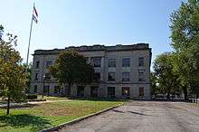 Crawford County Courthouse | |
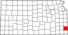 Location in the U.S. state of Kansas | |
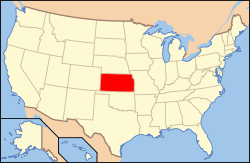 Kansas's location in the U.S. | |
| Founded | February 13, 1867 |
| Named for | Samuel J. Crawford |
| Seat | Girard |
| Largest city | Pittsburg |
| Area | |
| • Total | 595 sq mi (1,541 km2) |
| • Land | 590 sq mi (1,528 km2) |
| • Water | 5.3 sq mi (14 km2), 0.9% |
| Population | |
| • (2010) | 39,134 |
| • Density | 66/sq mi (25/km²) |
| Congressional district | 2nd |
| Time zone | Central: UTC-6/-5 |
| Website |
CrawfordCountyKansas |
Coordinates: 37°31′N 94°51′W / 37.517°N 94.850°W
Crawford County (county code CR) is a county located in Southeast Kansas. As of the 2010 census, the county population was 39,134.[1] Its county seat is Girard,[2] and its most populous city is Pittsburg. The county was named in honor of Samuel J. Crawford,[3] Governor of Kansas.
Located in the Osage Cuestas and Cherokee Lowlands, it lies halfway between Kansas City, Missouri and Tulsa, Oklahoma. Crawford County, and much of southeast Kansas, was founded on coal mining, the Pittsburg-Weir Coalfield being located here, and is still known for mining today. Pittsburg State University is located in Crawford County.
History
Early history
For many millennia, the Great Plains of North America was inhabited by nomadic Native Americans. From the 16th century to 18th century, the Kingdom of France claimed ownership of large parts of North America. In 1762, after the French and Indian War, France secretly ceded New France to Spain, per the Treaty of Fontainebleau.
19th century
In 1802, Spain returned most of the land to France, but keeping title to about 7,500 square miles. In 1803, most of the land for modern day Kansas was acquired by the United States from France as part of the 828,000 square mile Louisiana Purchase for 2.83 cents per acre.
In 1854, the Kansas Territory was organized, then in 1861 Kansas became the 34th U.S. state. In 1867, Crawford County was established. It is named for Samuel J. Crawford, who was the governor in office at the time of the county's establishment.[4]
21st century
On Sunday, May 4, 2003, a strong and violent F4 tornado touched down in western Crawford County, several miles west of Frontenac at around 4:40 p.m. The tornado remained on the ground throughout Crawford County until it entered neighboring Barton County, Missouri—traveling a total of 35 miles (56 km) and ending near Liberal, Missouri. The towns of Ringo, Franklin, and Mulberry, all in Crawford County, were devastated. The tornado cut a path of destruction roughly one quarter mile wide. Several F4 and F5 tornadoes hit Kansas, Missouri, and several other states that day, including the Kansas City metropolitan area. Six deaths were reported in Kansas, and Governor Sebelius declared much of eastern and southeastern Kansas a disaster area, including Crawford County.[5]
Geography
According to the U.S. Census Bureau, the county has a total area of 595 square miles (1,540 km2), of which 590 square miles (1,500 km2) is land and 5.3 square miles (14 km2) (0.9%) is water.[6]
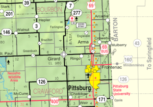
Adjacent counties
- Bourbon County (north)
- Vernon County, Missouri (northeast)
- Barton County, Missouri (east)
- Jasper County, Missouri (southeast)
- Cherokee County (south)
- Labette County (southwest)
- Neosho County (west)
Demographics
| Historical population | |||
|---|---|---|---|
| Census | Pop. | %± | |
| 1870 | 8,160 | — | |
| 1880 | 16,851 | 106.5% | |
| 1890 | 30,286 | 79.7% | |
| 1900 | 38,809 | 28.1% | |
| 1910 | 51,178 | 31.9% | |
| 1920 | 61,800 | 20.8% | |
| 1930 | 49,329 | −20.2% | |
| 1940 | 44,191 | −10.4% | |
| 1950 | 40,231 | −9.0% | |
| 1960 | 37,032 | −8.0% | |
| 1970 | 37,850 | 2.2% | |
| 1980 | 37,916 | 0.2% | |
| 1990 | 35,568 | −6.2% | |
| 2000 | 38,242 | 7.5% | |
| 2010 | 39,134 | 2.3% | |
| Est. 2015 | 39,217 | [7] | 0.2% |
| U.S. Decennial Census[8] 1790-1960[9] 1900-1990[10] 1990-2000[11] 2010-2013[1] | |||
The Pittsburg Micropolitan Statistical Area includes all of Crawford County.
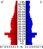
As of the U.S. Census in 2000,[12] there were 38,242 people, 15,504 households, and 9,441 families residing in the county. The population density was 64 people per square mile (25/km²). There were 17,221 housing units at an average density of 29 per square mile (11/km²). The racial makeup of the county was 93.29% White, 1.83% Black or African American, 0.94% Native American, 1.11% Asian, 0.09% Pacific Islander, 1.11% from other races, and 1.63% from two or more races. Hispanic or Latino of any race were 2.38% of the population. 23.5% were of German, 12.5% American, 10.4% English, 10.2% Irish and 8.6% Italian ancestry according to Census 2000.
There were 15,504 households out of which 28.50% had children under the age of 18 living with them, 47.90% were married couples living together, 9.30% had a female householder with no husband present, and 39.10% were non-families. 30.60% of all households were made up of individuals and 13.40% had someone living alone who was 65 years of age or older. The average household size was 2.35 and the average family size was 2.96.
In the county the population was spread out with 22.90% under the age of 18, 16.40% from 18 to 24, 25.00% from 25 to 44, 20.20% from 45 to 64, and 15.50% who were 65 years of age or older. The median age was 34 years. For every 100 females there were 95.00 males. For every 100 females age 18 and over, there were 92.40 males.
The median income for a household in the county was $29,409, and the median income for a family was $40,582. Males had a median income of $27,881 versus $21,517 for females. The per capita income for the county was $16,245. About 9.40% of families and 16.00% of the population were below the poverty line, including 17.00% of those under age 18 and 10.30% of those age 65 or over.
Law and government
Crawford County was a prohibition, or "dry", county until the Kansas Constitution was amended in 1986 and voters approved the sale of alcoholic liquor by the individual drink with a 30% food sales requirement. The food sales requirement was removed with voter approval in 1992.[13]
Education
Unified school districts
- Northeast USD 246 (Web site) - Serves the northeast portion of Crawford County, namely Lincoln and Washington Townships, including the towns of Arcadia, Arma, Cockerall, Camp 50, Franklin, Mulberry and Breezy Hill. Mascot - Vikings Colors - Burgundy and White
- Southeast USD 247 (Web site) - Serves primarily portions of Crawford and Cherokee counties, but also includes small portions of Labette and Neosho counties. The 300-square-mile (780 km2) district serves over 800 students in grades Pre-K through 12. Southeast High School (the "Lancers") is located just west of the city of Cherokee (the district office is located in the Cherokee/McCune Township). In Crawford County the district also serves the city of McCune.[14] Mascot - Lancers Colors - Columbia Blue and White
- Girard USD 248 (Web Site) - Serves Girard and the Girard Township, including the towns of Farlington, Walnut, Greenbush and Hepler. Mascot - Trojans Colors - Maroon and Yellow/Gold
- Frontenac USD 249 (Web site) - Serves Frontenac and the Frontenac Township, including the towns of Yale, Radley, Ringo and Mindenmines, Missouri. Mascot - Raiders Colors - Black and White/Silver
- Pittsburg USD 250 (Web site) - Serves Pittsburg and the Pittsburg Township, including the towns of Chicopee, Opolis, and Asbury, Missouri. Mascot - Purple Dragons Colors - Purple and White
Private schools
- Saint Mary's - Colgan (Web site) is a private Catholic K-12 school located in Pittsburg. Mascot - Panthers Colors - Blue and White
Higher education
- Pittsburg State University is located in Pittsburg.
Libraries
Communities
Cities
Unincorporated places
Townships
Crawford County is divided into nine townships. The cities of Frontenac, Girard, Mulberry, and Pittsburg are considered governmentally independent and are excluded from the census figures for the townships. In the following table, the population center is the largest city (or cities) included in that township's population total, if it is of a significant size.
| Township | FIPS | Population center |
Population | Population density /km² (/sq mi) |
Land area km² (sq mi) | Water area km² (sq mi) | Water % | Geographic coordinates |
|---|---|---|---|---|---|---|---|---|
| Baker | 03750 | Pittsburg | 3,640 | 25 (64) | 147 (57) | 0 (0) | 0.05% | 37°22′57″N 94°42′35″W / 37.38250°N 94.70972°W |
| Crawford | 16250 | Girard | 883 | 6 (14) | 159 (62) | 0 (0) | 0.09% | 37°30′3″N 94°51′13″W / 37.50083°N 94.85361°W |
| Grant | 27575 | No center city | 247 | 2 (4) | 145 (56) | 1 (0) | 0.45% | 37°30′10″N 95°1′8″W / 37.50278°N 95.01889°W |
| Lincoln | 40575 | Arcadia | 942 | 5 (13) | 181 (70) | 0 (0) | 0.23% | 37°37′21″N 94°39′31″W / 37.62250°N 94.65861°W |
| Osage | 53125 | McCune | 756 | 5 (14) | 141 (54) | 1 (0) | 0.44% | 37°22′46″N 95°1′21″W / 37.37944°N 95.02250°W |
| Sheridan | 64675 | Cherokee | 1,501 | 7 (19) | 206 (80) | 1 (0) | 0.31% | 37°22′32″N 94°51′33″W / 37.37556°N 94.85917°W |
| Sherman | 64875 | Farlington | 520 | 3 (7) | 187 (72) | 1 (0) | 0.45% | 37°37′24″N 94°51′35″W / 37.62333°N 94.85972°W |
| Walnut | 74975 | Walnut | 624 | 4 (10) | 166 (64) | 0 (0) | 0.27% | 37°36′15″N 95°1′38″W / 37.60417°N 95.02722°W |
| Washington | 75575 | Frontenac | 3,540 | 23 (59) | 154 (60) | 1 (1) | 0.96% | 37°31′7″N 94°41′44″W / 37.51861°N 94.69556°W |
| Sources: "Census 2000 U.S. Gazetteer Files". U.S. Census Bureau, Geography Division. | ||||||||
Area Attractions
- Pittsburg State University Veterans Memorial Amphitheater
- Girard Veterans Memorial & Big Flag
- Memorial to Kansas Vietnam Veterans
- Arma Veterans Memorial
- Crawford County Historical Museum
- Carona Depot & Railroad Museum
- Cato Historical School House
- Big Brutus
- Miner's Hall Museum
- McCune Osage Township Library & Museum
- Miners' Memorial & Immigrant Park
- Civilian Conservation Corps Memorial Trail
- William L. Abernathy Science Education Center
- Crawford State Park Beach & Playground
See also
|
|
References
- 1 2 "State & County QuickFacts". United States Census Bureau. Retrieved July 22, 2014.
- ↑ "Find a County". National Association of Counties. Archived from the original on 2011-05-31. Retrieved 2011-06-07.
- ↑ Gannett, Henry (1905). The Origin of Certain Place Names in the United States. Govt. Print. Off. p. 95.
- ↑ Blackmar, Frank Wilson (1912). Kansas: A Cyclopedia of State History, Embracing Events, Institutions, Industries, Counties, Cities, Towns, Prominent Persons, Etc. Standard Publishing Company. p. 471.
- ↑ "5 years later". The Morning Sun. 2008-05-04. Retrieved 2011-06-03.
- ↑ "US Gazetteer files: 2010, 2000, and 1990". United States Census Bureau. 2011-02-12. Retrieved 2011-04-23.
- ↑ "County Totals Dataset: Population, Population Change and Estimated Components of Population Change: April 1, 2010 to July 1, 2015". Retrieved July 2, 2016.
- ↑ "U.S. Decennial Census". United States Census Bureau. Archived from the original on May 11, 2015. Retrieved July 22, 2014.
- ↑ "Historical Census Browser". University of Virginia Library. Retrieved July 22, 2014.
- ↑ "Population of Counties by Decennial Census: 1900 to 1990". United States Census Bureau. Retrieved July 22, 2014.
- ↑ "Census 2000 PHC-T-4. Ranking Tables for Counties: 1990 and 2000" (PDF). United States Census Bureau. Retrieved July 22, 2014.
- ↑ "American FactFinder". United States Census Bureau. Archived from the original on 2013-09-11. Retrieved 2008-01-31.
- ↑ "Map of Wet and Dry Counties". Alcoholic Beverage Control, Kansas Department of Revenue. November 2006. Archived from the original on 2007-10-08. Retrieved 2007-12-28.
- ↑ Burns, Tim (September 19, 2005). "Welcome To USD #247". Cherokee, USD 247. Archived from the original on 2007-08-10. Retrieved 2007-01-23.
Further reading
- History of the State of Kansas; William G. Cutler; A.T. Andreas Publisher; 1883. (Online HTML eBook)
- Kansas : A Cyclopedia of State History, Embracing Events, Institutions, Industries, Counties, Cities, Towns, Prominent Persons, Etc; 3 Volumes; Frank W. Blackmar; Standard Publishing Co; 944 / 955 / 824 pages; 1912. (Volume1 - Download 54MB PDF eBook), (Volume2 - Download 53MB PDF eBook), (Volume3 - Download 33MB PDF eBook)
External links
| Wikimedia Commons has media related to Crawford County, Kansas. |
- County
- Crawford County - Official
- Crawford County - Directory of Public Officials
- Crawford County - Convention and Visitors Bureau
- Historical
- Maps
- Crawford County Maps: Current, Historic, KDOT
- Kansas Highway Maps: Current, Historic, KDOT
- Kansas Railroad Maps: Current, 1996, 1915, KDOT and Kansas Historical Society
 |
Bourbon County | Vernon County, Missouri | | |
| Neosho County | |
Barton County, Missouri | ||
| ||||
| | ||||
| Labette County | Cherokee County | Jasper County, Missouri |
Municipalities and communities of Crawford County, Kansas, United States | ||
|---|---|---|
| Cities | | |
| Townships | ||
| CDPs | ||
| Unincorporated communities | ||
| Footnotes | ‡This populated place also has portions in an adjacent county or counties | |