Youngstown–Warren–Boardman metropolitan area
| Metro Youngstown Youngstown–Warren–Boardman, OH–PA MSA Youngstown–Warren, OH–PA CSA | |
|---|---|
| CSA | |
|
Map of metro area (MSA in red, CSA in pink) | |
| Nickname(s): Mahoning Valley | |
| Country |
|
| States |
|
| Largest city | Youngstown |
| Elevation | 660–3,001 ft (200–915 m) |
| Population (2012/2010) | |
| • Urban | 602,964 |
| • MSA | 565,773 |
| • CSA | 715,039 |
|
MSA/CSA = 2012, Urban = 2010 | |
| Time zone | EST (UTC-5) |
| • Summer (DST) | EDT (UTC-4) |
| ZIP codes | 16xxx to 44xx |
| Area code(s) | 330, 234, 724 |
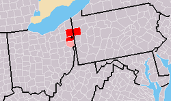
The Youngstown metropolitan area, typically known as the Steel Valley as well as Mahoning Valley, is a metropolitan area in Northeast Ohio in the United States, with the city of Youngstown, Ohio at its center. According to the US Census Bureau, the metropolitan statistical area (MSA) includes Mahoning and Trumbull counties in Ohio and Mercer county in Pennsylvania. As of the 2010 census, the MSA had a population of 565,773.
This area also has a strong commuter interchange with Cleveland and Pittsburgh and their metropolitan areas. It is located at the geographic center of the Rust Belt of the United States which stretches from Minneapolis in the west to Johnstown and Altoona in the east.
Steel industry history
Although steel has been produced in the Mahoning Valley since the mid-1800s, after the Civil War, the valley was primarily known for its iron production. Conversion to steel manufacturing began during the economic depression of the 1890s.[1] The Mahoning Valley is suitable for steel manufacture because of "its proximity to the Lake Erie ports that receive iron ore…the coal fields of Ohio, Pennsylvania and West Virginia; and to limestone deposits."[2] The "25-mile stretch of steel mills and related industries" along the Mahoning River is similar to the Ruhr Valley in Germany."[2] Historically, it was the largest steel producing region in the world (including all of Northeast Ohio and Western Pennsylvania).
The local steel industry declined during the 1970s steel crisis. A notable plant closure occurred on September 19, 1977, when Youngstown Sheet and Tube abruptly closed its Campbell Works and furloughed 5,000 workers.[3] Today the area produces little steel, and is home to many scrap metal yards and aluminum plants.[4] A 2009 documentary titled "Steel Valley: Meltdown" describes "the past, present and future of the Mahoning Valley" through the eyes of local experts, including one local organizer who stated, "We are the first generation completely removed from the days when steel mills were active."[5]
The Mahoning Valley Economic Development Corporation, founded in 1979, is active in economic revitalization and diversification. It owns two industrial parks, and has purchased local rail lines, including the Youngstown and Austintown Railroad and the Warren and Trumbull Railroad.[6]
Municipalities
Largest municipalities
| 2015 rank | City | County (State) | 2015 estimate | 2010 Census | Change | Highest Population (Year) |
|---|---|---|---|---|---|---|
| 1 | Youngstown | Mahoning (Ohio) | 64,628 | 66,982 | −3.51%[7] | 170,002 (1930) |
| 2 | Warren | Trumbull (Ohio) | 40,245 | 41,557 | −3.16%[8] | 63,494 (1970) |
| 3 | Alliance | Stark and Mahoning (Ohio) | 22,055 | 22,322 | −1.20%[9] | 28,362 (1960) |
| 4 | Niles | Trumbull (Ohio) | 18,651 | 19,266 | −3.19%[10] | 23,072 (1980) |
| 5 | Hermitage | Mercer (Pennsylvania) | 16,220 | 16,365 | −0.89%[11] | 16,365 (1980) |
| 6 | Sharon | Mercer (Pennsylvania) | 13,562 | 14,038 | −3.39%[12] | 26,454 (1950) |
| Census-Designated Place | Boardman | Mahoning (Ohio) | ||||
| Census-Designated Place | Austintown | Mahoning (Ohio) |
Cities, villages, and boroughs
|
Mahoning County
|
Trumbull County |
Columbiana County (CSA) |
Mercer County |
Townships
Demographics
| Historical population | |||
|---|---|---|---|
| Census | Pop. | %± | |
| 1940 | 473,605 | — | |
| 1950 | 528,498 | 11.6% | |
| 1960 | 636,525 | 20.4% | |
| 1970 | 663,178 | 4.2% | |
| 1980 | 659,649 | −0.5% | |
| 1990 | 613,622 | −7.0% | |
| 2000 | 602,978 | −1.7% | |
| 2010 | 565,773 | −6.2% | |
| Est. 2015 | 549,885 | [13] | −2.8% |
| U.S. Decennial Census[14] | |||
As of the census[15] of 2000, there were 602,978 people, 238,319 households, and 162,896 families residing within the MSA. The racial makeup of the MSA was 86.88% White, 10.78% African American, 0.15% Native American, 0.45% Asian, 0.02% Pacific Islander, 0.55% from other races, and 1.17% from two or more races. Hispanic or Latino of any race were 1.70% of the population.
The median income for a household in the MSA was $36,071, and the median income for a family was $44,055. Males had a median income of $35,626 versus $23,186 for females. The per capita income for the MSA was $18,547.
Combined statistical area
The Youngstown–Warren combined statistical area is made up of four counties – three in northeast Ohio and one in western Pennsylvania. The statistical area includes one metropolitan area and one micropolitan area. As of the 2000 Census, the CSA had a population of 715,039 (though a July 1, 2009 estimate placed the population at 670,685).[16]
- Metropolitan statistical areas (MSAs)
- Youngstown–Warren–Boardman (Mahoning County and Trumbull County, Ohio, and Mercer County, Pennsylvania)
- Micropolitan statistical areas (μSAs)
See also
References
- ↑ "Ohio: Rise and Fall of the Steel Industry in the Mahoning Valley". (Local Legacies: Celebrating Community Roots – Library of Congress). Retrieved 2014-03-03.
- 1 2 "Mahoning Valley". Ohio Turnpike and Infrastructure Commission. Retrieved 2014-03-03.
- ↑ Christie, Les. "The incredible shrinking city". CNNMoney.com. Retrieved 2004-04-24.
- ↑ Linkon, Sherry Lee; John Russo (2002). Steeltown U.S.A: work and memory in Youngstown. Lawrence, Kan.: University Press of Kansas. ISBN 978-0-7006-1161-4.
- ↑ Libecco, Katie (2009-09-19). "Local documentary gathers expert insight". Valley24.com. Retrieved 2014-03-04.
- ↑ "Mahoning Valley Economic Development Corporation – Revitalizing the Mahoning Valley". Retrieved 2014-03-03.
- ↑ http://www.census.gov/quickfacts/table/PST045215/3975126,4234064,4269720,3955916,3980892,3988000
- ↑ http://www.census.gov/quickfacts/table/PST045215/3975126,4234064,4269720,3955916,3980892,3988000
- ↑ http://www.census.gov/quickfacts/table/PST045215/3901420,00
- ↑ http://www.census.gov/quickfacts/table/PST045215/3975126,4234064,4269720,3955916,3980892,3988000
- ↑ http://www.census.gov/quickfacts/table/PST045215/3975126,4234064,4269720,3955916,3980892,3988000
- ↑ http://www.census.gov/quickfacts/table/PST045215/3975126,4234064,4269720,3955916,3980892,3988000
- ↑ "US Census QuickFacts". Retrieved July 3, 2016.
- ↑ United States Census Bureau. "Census of Population and Housing". Retrieved July 3, 2016.
- ↑ "American FactFinder". United States Census Bureau. Retrieved 2008-01-31.
- ↑ "Table 2. Annual Estimates of the Population of Combined Statistical Areas: April 1, 2000 to July 1, 2009 (CBSA-EST2009-02)" (CSV). 2009 Population Estimates. United States Census Bureau, Population Division. 2010-03-23. Retrieved 2010-03-30.
Coordinates: 41°15′N 80°43′W / 41.250°N 80.717°W
| |||||||
| Neighborhoods |
|  | |||||
| History |
| ||||||
| Sports |
| ||||||
| Education |
| ||||||