Pudukkottai district
| Pudukkottai District புதுக்கோட்டை மாவட்டம் Pudhugai Mavattam | |
|---|---|
| District | |
|
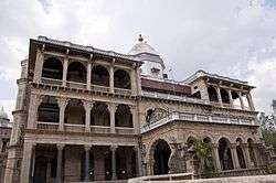
King's Palace, Pudukkottai | |
 Location in Tamil Nadu, India | |
| Coordinates: 10°23′N 78°49′E / 10.38°N 78.82°ECoordinates: 10°23′N 78°49′E / 10.38°N 78.82°E | |
| Country |
|
| State | Tamil Nadu |
| District | Pudukkottai |
| Pudukkottai | 14 January 1974 |
| Headquarters | Pudukkottai |
| Talukas | Pudukkottai, Karambakkudi, Alangudi, Aranthangi, Thirumayam, Ponnamaravathi, Gandarvakottai, Avudaiyarkoil, Manamelkudi, Kulathur, Iluppur. |
| Government | |
| • Collector & District Magistrate | S. Ganesh IAS |
| • Superintendent of Police | Dr. J. Loganathan IPS |
| Area | |
| • Total | 4,663 km2 (1,800 sq mi) |
| Population (2011) | |
| • Total | 1,618,345 |
| • Density | 350/km2 (900/sq mi) |
| Languages | |
| • Official | Tamil, English |
| Time zone | IST (UTC+5:30) |
| PIN | 622xxx |
| Telephone code | 04322 |
| ISO 3166 code | [[ISO 3166-2:IN|]] |
| Vehicle registration | TN-55 |
| Coastline | 42 kilometres (26 mi) |
| Largest city | Pudukkottai |
| Nearest city | Tiruchirapalli, Thanjavur |
| Sex ratio | M-50%/F-50% ♂/♀ |
| Literacy | 80%% |
| Legislature type | elected |
| Lok Sabha constituency | 0 (Defunct) |
| Precipitation | 827 millimetres (32.6 in) |
| Avg. summer temperature | 40.9 °C (105.6 °F) |
| Avg. winter temperature | 17.8 °C (64.0 °F) |
| Website |
pudukkottai |
Pudukkottai District is a district of Tamil Nadu state in southern India. The city of Pudukkottai is the district headquarters. It is also known colloquially as Pudhugai. Pudukkottai district is one of the least urbanised district in Tamil Nadu.
Pudukkottai district is bounded on the northeast and east by Thanjavur District, on the southeast by the Palk Strait, on the southwest by Ramanathapuram and Sivaganga districts, and on the west and northwest by Tiruchirapalli District. As of 2011, the district had a population of 1,618,345 with a sex-ratio of 1,015 females for every 1,000 males.
The district has an area of 4,663 km² with a coastline of 42 km. The district lies between 78° 25' and 79° 15' east longitude and between 9° 50' and 10° 40' of the north latitude.
Organisation
On 14 January 1975, Pudukkottai was organised as a separate district comprising the former Pudukkottai Division of Tiruchirappalli district with some additions from Thanjavur District. At present, this district is composed of three Revenue Divisions, namely, Pudukkottai,Aranthangi and Illupur and eleven Taluks, namely, Kulathur, Illuppur, Alangudi Pudukkottai, Gandarvakottai, Thirumayam, Aranthangi, Ponnamaravathi, Karambakudi, Avudaiyarkoil and Manamelkudi. There are 762 Revenue Villages.
The population of the district is 1,618,725 (as per Census 2011). It is 17.02% urbanised.[1] The district depends a great deal on the monsoon for its water supply. The district population is 77.96% literate.
Demographics
According to 2011 census, Pudukkottai district had a population of 1,618,345 with a sex-ratio of 1,015 females for every 1,000 males, much above the national average of 929.[2] A total of 179,688 were under the age of six, constituting 91,696 males and 87,992 females. Scheduled Castes and Scheduled Tribes accounted for 17.6% and .08% of the population respectively. The average literacy of the district was 68.62%, compared to the national average of 72.99%.[2] The district had a total of 387,679 households. There were a total of 761,693 workers, comprising 192,462 cultivators, 234,344 main agricultural labourers, 10,170 in house hold industries, 203,272 other workers, 121,445 marginal workers, 16,808 marginal cultivators, 70,805 marginal agricultural labourers, 3,771 marginal workers in household industries and 30,061 other marginal workers.[3]
External links
| Wikimedia Commons has media related to Pudukkottai district. |
- Pudukkottai District
- Tourism
References
- ↑
- 1 2 "Census Info 2011 Final population totals". Office of The Registrar General and Census Commissioner, Ministry of Home Affairs, Government of India. 2013. Retrieved 26 January 2014.
- ↑ "Census Info 2011 Final population totals - Pudukkottai district". Office of The Registrar General and Census Commissioner, Ministry of Home Affairs, Government of India. 2013. Retrieved 26 January 2014.
 |
Tiruchirappalli district | Thanjavur District | | |
| Sivaganga district | |
|||
| ||||
| | ||||
| Ramanathapuram district | Palk Strait |
| State symbols |
|
|---|---|
| Governance |
|
| Topics | |
| Districts |
|
| Major cities | |
| District Headquarters | | |
|---|---|---|
| Country | ||
| State | ||
| Region | ||
| Divisions |
| |
| Taluks | ||
| Villages | ||
| Revenue blocks | ||
| Municipalities | ||
| Rivers | ||
| History | ||
| Places of interest | ||
| ||