Aliyar Reservoir
| Aliyar Reservoir/Aliyaru Reservoir | |
|---|---|
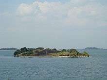
 'Aerial view of Aliyar Reservoir, Dam at top | |
| Location | Coimbatore District, Tamil Nadu |
| Coordinates | 10°28′26″N 76°58′22″E / 10.4739°N 76.9728°ECoordinates: 10°28′26″N 76°58′22″E / 10.4739°N 76.9728°E |
| Lake type | reservoir[1][2] |
| Primary inflows | Aliyar river |
| Catchment area | 468.8 km2 (181.0 sq mi) |
| Basin countries |
|
| Max. length | 2 km (1.2 mi) |
| Surface area | 6.48 km2 (2.50 sq mi) |
| Average depth | 18.2 m (60 ft) |
| Max. depth | 36.5 m (120 ft) |
| Water volume | 109,416,297 km3 (26,250,366 cu mi) |
| Shore length1 | 16.0 km (9.9 mi) |
| Surface elevation | 320 m (1,050 ft) |
| Islands | 1 |
| 1 Shore length is not a well-defined measure. | |
Aliyar (ஆழியாறு) (also spelt Azhiyar / Aaliyar) Reservoir is a 6.48 km2 (2.5 sq mi) reservoir located in Aliyar village near Pollachi town in Coimbatore District, Tamil Nadu, South India. The dam is located in the foothills of Valparai, in the Anaimalai Hills of the Western Ghats.[3] It is about 65 kilometres (40 mi) from Coimbatore. The dam offers some ideal getaways including a park, garden, aquarium, play area and a mini Theme-Park maintained by Tamil Nadu Fisheries Corporation for visitors enjoyment. The scenery is beautiful, with mountains surrounding three quarters of the reservoir. Boating is also available.[4]
History
The Aliyar Dam was constructed during 1959-1969 across the Aliyar river, mainly for irrigation purposes. The project was commissioned in September 2002 to generate Hydro Electric Power.
Hydrography
Aliyar lake receives water from Upper Aliyar Reservoir through the hydroelectric power station in Navamali and the Parambikulam reservoir through a contour canal. Aliyar dam, built as a part of Parambikulam aliyar project (PAP), retains a large reservoir.[4] The dam is around 2 kilometres (1.2 mi) in length.
The lowest level outlet of the reservoir is 930 feet (280 m) above Mean Sea Level (MSL) and the canal intake is 980 feet (300 m) above MSL. The spillway is 1,040 feet (320 m) above MSL and the FRL (Full Reservoir Level) is 1,050 feet (320 m) above MSL. The maximum surface area is 48 hectares (120 acres) (1,600 acres). The volume of water at FRL is 3.864 Tmcft (88,705 acre feet (109,416,000 m3)). The maximum depth is 41 metres (135 ft) and the mean depth 16.8 metres (55 ft) . The volume development is 1.2 m. The highest inflow usually occurs during July and August. The shoreline is poorly indented, the shore development is poor and shallow and the Aquatic plants and limnology of the littoral zone is also very limited.[1]
Fisheries
Ailyar reservoir was studied by the Central Inland Fisheries Research Institute (CFRI) for eleven years from 1982 to 1992. The rate of energy conversion at primary producer level and at the fish production level at Aliyar is considered higher than in any other Indian reservoir. The indigenous fish of the reservoir includes 40 species belonging to 13 families, plus seven stocked species[2]
Hydel Power Project

This project consists of a series of dams interconnected by tunnels and canals for harnessing the waters of the Parambikulam, Aliyar, Sholiyar, Thunakadavu, Thekkadi and Palar rivers, flowing at various elevations, for irrigation and power generation. The scheme is an outstanding example of engineering skill. At present, the discharges are being let down through three sets of slucies/ canals, viz., Pollachi Canal, Vettaikaranpudur Canal and the river sluices. Under this scheme, the irrigation discharges let down through river slucies of the Aliyar Dam utilized for power generation in a power house at the toe of the dam. Being a micro hydel scheme, this project is subsidized by the Ministry of Non-conventional Energy Sources, Government of India.
Visitor information

Aliyar dam is a popular tourist destination.[5] Near Aliyar dam are some visitor attractions including a park, garden, aquarium, play area and a mini Theme-Park maintained by Tamil Nadu Fisheries Corporation for visitors enjoyment. Temple of Consciousness is situated near Aliyar dam entrance at Arutperunjothi Nagar, where Vethathiri Maharishi resides. The scenery is beautiful, with mountains surrounding three quarters of the reservoir. Boating is also available.[4] Monkey Falls is located at 6 km from the dam next to Arutperunjothi Nagar and Forest Department Checkpost.[1] Overnight stay is possible in the forest rest house. A treetop house provides accommodation for the adventurous.[6]
See also
References
| Wikimedia Commons has media related to Aliyar Reservoir. |
- 1 2 3 Limnological studies on parambikulam Aliyar-project-I Aliyar Reservoir (Madras State), India Journal Aquatic Sciences - Research Across Boundaries, Birkhäuser Basel, ISSN 1015-1621 (Print) 1420-9055 (Online), Volume 32, Number 2 /, September, 1970, DOI 10.1007/BF02502556, pp 405-417, SpringerLink, 11 October 2006
- 1 2 Sugunan, V.V.; Fisheries and Aquaculture Department (1995). "2. TAMIL NADU (Continued) 2.7 ALIYAR RESERVOIR". Reservoir fisheries of India. Fisheries Technical Paper T345 1995. FAO. ISBN 92-5-103673-X.
- ↑ Aliyar Dam.
- 1 2 3 Pollachi Dams
- ↑ "சுற்றுலா பயணிகள் குவிந்ததால் களைகட்டியது ஆழியாறு அணை". Dina Malar. 7 November 2010. Retrieved 7 November 2010.
- ↑ Infrastructure Development & Tourism, Govt. of Tamil Nadu
| District Headquarters |  --> --> | |
|---|---|---|
| Country | ||
| State | ||
| Region | ||
| Taluks | ||
| Municipal Corporations | ||
| Municipalities | ||
| Rivers | ||
| History | ||
| Places of interest |
| |
| Universities | ||
| ||