Driftless Area
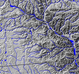
The Driftless Area or Paleozoic Plateau is a region in the American Midwest noted mainly for its deeply carved river valleys. While primarily in southwestern Wisconsin, it includes areas of southeastern Minnesota, northeastern Iowa and extreme northwestern Illinois. The region includes elevations ranging from 603 to 1,719 feet (184 to 524 m) and covers an area of 16,203 square miles (42,000 km2). The region's peculiar terrain is the result of its having escaped glaciation in the last glacial period.[1][2]
Geologic formation
Retreating glaciers leave behind silt, clay, sand, gravel, and boulders called drift. Glacial drift includes unsorted material called till and layers deposited by meltwater streams called outwash[3] While some glacial drift has been discovered, this is said to be of Pre-Illinoian age, about 500,000 years old.[2][4][5]
The region has been subject to the regular catastrophic effects of glacial lake outburst floods involving the cataclysmic collapse of ice dams holding in such bodies as Glacial Lake Agassiz, Glacial Lake Grantsburg, and Glacial Lake Duluth.
The last phases involved several major lobes: the Des Moines lobe, which flowed down toward Des Moines on the west; the Superior lobe and its sublobes on the north; and the Green Bay lobe and Lake Michigan lobes on the east.[6] The northern and eastern lobes were in part diverted around the area by the Watersmeet Dome, an ancient uplifted area of Cambrian rock underlain by basalt. The Green Bay and Lake Michigan lobes were also partially blocked by the bedrock of the Door Peninsula, which presently separates Green Bay from Lake Michigan.[6] In earlier phases of the Wisconsinan, the Driftless Area was totally surrounded by ice, with eastern and western lobes joining together to the south of it.
The latest concept of the origin of the Driftless Area is the pre-Illinoian continental glacial ice flowing over the Driftless Area and depositing on it pre-Illinoian till, which is more than 790,000 years old. When the ice retreated and uncovered the area, periglacial erosion removed it: Anticyclonic snow-bearing winds episodically dropped large amounts of snow, which then gradually removed superficial sediment by solifluction and snowmelt overland flow, so-called sheetwash.[7]
In the adjacent glaciated regions, the glacial retreat left behind drift, which buried all former topographical features. Surface water was forced to carve out new stream beds.[8]
Characteristic landforms
Geology
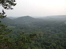
Overall, the region is characterized by an eroded plateau with bedrock overlain by varying thicknesses of loess. Most characteristically, the river valleys are deeply dissected. The bluffs lining this reach of the Mississippi River currently climb to nearly 600 feet (180 m). In Minnesota, Pre-Illinoian-age till was probably removed by natural means prior to the deposition of loess. The sedimentary rocks of the valley walls date to the Paleozoic Era and are often covered with colluvium or loess.[9] Bedrock, where not directly exposed, is very near the surface and is composed of "primarily Ordovician dolomite, limestone, and sandstone in Minnesota, with Cambrian sandstone, shale, and dolomite exposed along the valley walls of the Mississippi River."[9] In the east, the Baraboo Range, an ancient, profoundly eroded monadnock, consists primarily of Precambrian quartzite and rhyolite. The area has not undergone much tectonic action, as all the visible layers of sedimentary rock are approximately horizontal.
Karst topography is found throughout the Driftless area. This is characterized by caves and cave systems, disappearing streams, blind valleys, underground streams, sinkholes, springs, and cold streams. Disappearing streams occur where surface waters sinks down into the earth through fractured bedrock or a sinkhole, either joining an aquifer, or becoming an underground stream. Blind valleys are formed by disappearing streams and lack an outlet to any other stream. Sinkholes are the result of the collapse of the roof of a cave, and surface water can flow directly into them. Disappearing streams can re-emerge as large cold springs. Cold streams with cold springs as their sources are noted as superb trout habitat.
Rivers
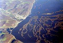
The Mississippi River passes through the Driftless Area between and including Pool 2 and Pool 13.
As rivers and streams approach their confluence with the Mississippi, their canyons grow progressively steeper and deeper, particularly in the last 25 miles (40 km) in their journey to their mouths. The change in elevation above sea level from ridgetops lining a stream to its confluence with the Big River can reach well past 650 feet (200 m) in only a few miles. The Waukon Municipal Airport is reliably established as being 1,281 feet (390 m) above sea level.[10] The Army Corps of Engineers maintains a river level in Pool 9 of about 619 feet (189 m) above sea level,[11] which covers Lansing. Maps and signs issued by the Iowa Department of Transportation indicate Waukon and Lansing are 17 miles (27 km) apart on Iowa Highway 9. This is a drop of more than 660 feet (200 m) in less than 20 miles (32 km) (and this along a very minor tributary of the Mississippi). "The role of isostatic rebound on the process of stream incision in the area is not clearly understood."[12]
There are many small towns in the Driftless Area, especially in river valleys, at or upstream from the Mississippi. Small towns in a deep steep valley going down to the Mississippi are at risk every 50 to 100 years or so of a major flood, as with the wreck of Gays Mills, Wisconsin, in August 2007, or the holding of the levee in Houston, Minnesota, (on the South Fork Root River) at the same time. Metropolitan areas have flood walls (See 2007 Midwest flooding).
The history of this portion of the Upper Mississippi actually dates back to an origin "as an ice-marginal stream during what had been referred to as the “Nebraskan glaciation.”" Current terminology would place this outdated and abandoned period in the Pre-Illinoian Stage.[12] The level of erosion often exposes Cambrian limestone of about 510 million years of age.[13]
The Mississippi River trench is one of the few places in the Driftless Area where the bedrock is very deep below the surface, and is overlain by large amounts of sediment.[14] As home to the formation of a substantial portion of the gorge of the Upper Mississippi, this enormous quantity of sediment goes down at least 300 feet (91 m) under the present riverbottom at the confluence of the Wisconsin River.[15] In contrast, as the River exits the Driftless Area "between Fulton and Muscatine, [... (Pool 13)], it flows over or near bedrock."[16] "The course of the upper Mississippi River along the margin of the Driftless Area of southeastern Minnesota is believed to have been established during pre-Wisconsin time when a glacial advance from the west displaced the river eastward from central Iowa to its present position."[17]
Other rivers affected by this geologic process are:
- In Wisconsin, the Chippewa, Trempealeau, La Crosse, Black, Pecatonica, and Wisconsin Rivers, along with the Wisconsin River's tributary, the Kickapoo River;
- In Minnesota: the Whitewater, Cannon, Zumbro, and Root rivers;
- In Iowa: the Upper Iowa (and Paint Creek), Yellow, Turkey, and Maquoketa rivers;
- In Illinois: the Apple River and the Galena River (a.k.a. the Fever River).
The Saint Croix in Minnesota and Wisconsin is another important river in the Driftless Area, as it was the outlet for Glacial Lake Duluth, forerunner to Lake Superior, when the eastern outlet was blocked by the continental ice sheet. These rivers all have deep, dramatic canyons giving testimony to the immense quantity of water which once surged through them. The Wisconsin River drained Glacial Lake Wisconsin. Glacial River Warren, whose bed is now occupied by the Minnesota River, drained the colossal Glacial Lake Agassiz. There was ample water to dig a very deep, hundreds-of-miles-long gash into the North American bedrock.
Ecosystem

The climate is humid continental, displaying both the cool summer and warm summer subtypes as one travels from north to south.[18] The United States Department of Agriculture has the region falling mainly in zones 4a and 4b, with the southern fringe being 5a. A few patches in Wisconsin are 3b. The winters in zones 4a and 4b can be quite severe, with the Mississippi freezing over.
Prior to European settlement in the 19th century, the vegetation consisted of tallgrass prairie and bur oak savanna on ridgetops and dry upper slopes, sugar maple-basswood-oak forest on moister slopes, sugar maple-basswood forests in protected valleys and on north-facing slopes, wet prairies along the rivers and some mesic prairie on the floodplain farther back from the river. There were probably also oak forests that contained no sugar maple. Marsh and floodplain forests were also common on river flood plains. Prairie was restricted primarily to the broader ridge tops, which were unfavorable sites for trees due to thin soils and shallow bedrock, rapid drainage, and desiccating winds; all these conditions were also good for carrying fires across the landscape. Prairies also occurred on steep slopes with south or southwest aspect (see goat prairie[9]). Natural fire, which has long been vigorously suppressed, was essential for the regeneration of such prairies.
The Midwest Driftless Area Restoration Effort is a multi-agency cooperative effort to restore the landscape.[19] The main issues are water pollution from agricultural and animal runoff, and erosion. Water pollution is particularly critical in karsted regions such as this, in that it can degrade or destroy prime cold water fish habitat. Soil erosion presents the Army Corps of Engineers with a particular problem, in that it requires them to dredge the Mississippi River shipping channels to keep them open. Trout Unlimited is part of this effort, if only because of the superb cold-water streams the region supports.[20] A symposium was held in October 2007 in Decorah, Iowa, "to share the results of research, management and monitoring work in the Driftless Area."[21] The Nature Conservancy is also interested.


An apparently unique feature of the Driftless Area are small, isolated ecosystems termed algific talus slopes. These refugia create cool summer and fall microclimates which host species usually found further north. They contain at least one endangered species, the Iowa Pleistocene Snail, and a threatened plant, the Northern monkshood.[22] The Driftless Area National Wildlife Refuge was primarily carved out of the Upper Mississippi River National Wildlife and Fish Refuge in order to protect these species and their associated ecosystems.
A particularly noteworthy annual event is the rising of fishflies, a kind of mayfly endemic to the Mississippi valley in the region. These are aquatic insects attracted to light, which rise by the millions as adults to mate, only to die within hours.[23]
Wildlife is abundant with opportunities for hunting whitetail deer and wild turkey. Fishing, particularly for brown trout, brook trout and rainbow trout in tributaries, and species such as channel catfish in the Mississippi is available, with ice fishing in winter.
Other characteristics
The Driftless Area is part of the Mississippi Flyway. Many birds fly over the river in large flocks, going north in spring and south in autumn.
There are very few natural lakes in the region, these being found in adjoining areas of glacial till, drift and in moraines; the region is extraordinarily well drained, and there is rarely a place where even a pond can naturally form. There are also very few dams in that the valley walls and floors are very often fissured or crumbly, or very porous, providing very poor anchors for a dam or making it difficult to keep any kind of reservoir appropriately filled. There are no real waterfalls, but some very strong springs bear the name.
A modern, man-made characteristic is the comparatively twisty nature of highways in the region, such as in Kentucky, in contrast to the usually rigid east-west/north-south alignment elsewhere in the Midwest. Here, the roads switchback up stream valleys or travel over ridge tops. The route of U.S. Highway 20 through the Driftless, and particularly in Illinois, is a good example.
The bioregion shares economic and cultural characteristics, as well. These were federally recognized with the granting of the Upper Mississippi River Valley viticultural area by the Treasury Division's Tax and Trade Bureau in 2009.[24] The UMRV is the largest designated winemaking region in the country. The petition for designation includes a 16-page narrative that spells out why this region is a cohesive whole for marketing wine, and is now used to market other products.[25]
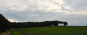
At the University of Wisconsin-Madison, the Center for Integrated Agricultural System's Food and Farm project is working with the region's sustainable-agriculture farmers, processors, distributors, chefs, planning commissions, and others to define the culinary identity of the region and direct the development of agrotourism. For instance, 75% of the raw-milk artisan cheese produced in Wisconsin is made in the Driftless region. This cheese is made from milk produced by cows that graze on pastures. The region is home to Organic Valley, the nation's largest organic dairy cooperative. Generally, organic dairy production fits best with a grass-based milk production system. In addition to winegrape production and wine-making, the region also is known for apple production, and a number of hard cider makers are about to hit the market with product. The region is historically known for grass-fed beef, and has great potential to market forest botanicals - especially mushrooms - to the 21 million people in the region, including Minneapolis-St. Paul and Chicago-Milwaukee markets.
Geographic extent
Minnesota

Corresponding to the southeast geological region of Minnesota, the Driftless Area begins at about Fort Snelling on the southeast corner of the Minneapolis-Saint Paul metro area. Starting as a narrow sliver against the Mississippi, it widens to the west as one goes south. The western boundary is the Bemis-Altamont moraine.[26][27] Another more easily located reference to the western boundary is the approximate line of Minnesota State Highway 56.
The dissection of river valleys along the Mississippi is complete, and one has to travel westward to find remains of the former plateau. The historic vegetation was mixed woodland, with occasional goat prairies on southwesterly facing slopes.[28] In the western section is "an old plateau covered by loess [...] along the eastern border and pre-Wisconsin age glacial till in the central and western parts. The western portion is a gently rolling glacial till plain that is covered by loess in places."[27]
The counties involved include all or part of Dakota, Goodhue, Wabasha, Winona, Olmsted, Dodge, Houston, Fillmore, and Mower. Aside from the southeastern suburban sprawl of the Twin Cities, Rochester is the main urban area. Additional communities include Red Wing, Lake City, Winona, La Crescent and Caledonia.
Glacial River Warren, in whose bed the Minnesota River now flows, entered the Driftless Area just downriver from present-day Minneapolis-Saint Paul, at Fort Snelling, over River Warren Falls, "an impressive 2700 feet (823 m) across and 175 feet (53 m) tall, over 10 times as wide as Niagara falls"[29] (this has since receded to become Saint Anthony Falls). The region is characterized "by the absence of glacial drift deposits, the sculpted topography, and the presence of the ancient limestone immediately beneath the soil and in cliff outcroppings."[30] The Minnesota Driftless Area did not reach the Twin Cities or any areas to the north or west of them; rather, the Twin Cities marked the edge of glaciation, with substantial terminal moraines overlying the region.[31]
The largest protected area is Richard J. Dorer Memorial Hardwood State Forest, which contains some state-owned land, but is mostly private, controlled by state conservation easements.
Wisconsin
Around 85% of the Driftless Area lies within Wisconsin. The border is defined by the catchment of the Chippewa River on the north, and somewhat west of the north-south line of the Wisconsin River. Where the Wisconsin River turns west to join the Mississippi, the area to the south, to include the whole of Grant County as well as most of Lafayette County are included.
Karst topography is most prominent in Wisconsin. Viroqua City Cave in Viroqua and Cave of the Mounds, near Blue Mounds, WI, are better known ones. There is an admission that Wisconsin geologists have been remiss in fully documenting their caves, inside or outside of the Driftless.[32]
It involves all or part of Pierce, Pepin, Eau Claire, Buffalo, Trempealeau, Jackson, La Crosse, Monroe, Juneau, Vernon, Richland, Sauk, Crawford, Iowa, Dane, Green, Grant, and Lafayette counties. La Crosse is the principal urban area wholly within the Driftless Area, while the larger Madison's far western suburbs are located on the edges of the area. The most rugged part of Wisconsin's Driftless area is also called the Ocooch Mountains.
Largely rural in character, land cover is forest, farmland, and grassland/pasture; modest wetlands are found in river valleys, and along the Mississippi.[33] Row crop farming is less encountered than elsewhere in the state.[34] Away from the Mississippi, the terrain is gently rolling, supporting dairy farms.
The highest point in the Driftless area is West Blue Mound, with an elevation of 1,719 feet (524 m).[35][36] The feature is located in Blue Mound State Park, in Iowa County.
Iowa
The contrast between what the rest of Iowa looks like and what the Driftless Area presents is often commented upon.[37] For counties inland from the Mississippi, the evidence is largely confined to the valleys of streams and rivers. It encompasses all of Allamakee, and part of Clayton, Fayette, Delaware, Winneshiek, Howard, Dubuque, and Jackson counties. Dubuque is the only metropolitan area.
The region is distinct from the "Iowan Erosion Surface to the west and the Southern Iowa Drift Plain to the south."[12] A line east of the most easterly tributaries of the Wapsipinicon River defines the terminal moraine that marks the western boundary of the Driftless, with the catchment of the Maquoketa River serving as a southern boundary. The most western tributaries of the Upper Iowa, Yellow and Turkey Rivers flow east and south from the vicinity of this moraine.
Outside of Dubuque, this region of Iowa is thinly populated. In the western section, agriculture and livestock raising are the norm. As one travels east, and as the valleys tumble down to the Mississippi, much of the land is virtually wild, with a great deal of it publicly owned. The state maintains an extensive number of wildlife management areas (basically hunting and fishing areas), along with state forests and state parks.
The most impressive area is on the Mississippi, between Pikes Peak State Park, opposite the Wisconsin River down to Guttenberg, where bluffs lining the river reach their maximum height. This is apparently an Iowa continuation of Military Ridge, a catchment-defining divide in Wisconsin that was used for the Military Ridge Road, a portion of which is included in Military Ridge State Trail, both across the River in Wisconsin.
Effigy Mounds National Monument is at the heart of a network of adjacent parks, state forests, preserves, as well as national wildlife refuges, all of which preserve and illustrate the features of the Driftless, where "patchy remnants of Pre-Illinoian glacial drift more than 500,000 years old recently have been discovered in the area."[38] Additional protected areas are Cold Water Spring State Preserve near Decorah and Maquoketa Caves State Park northwest of Maquoketa.
Illinois
The Illinois portion of the Driftless Area is confined mainly to Jo Daviess County; western parts of Carroll County (the Mississippi River bluffs characteristic of the Driftless terminate around Savanna) and a tiny portion of northwest Whiteside County are also included.[40] The region contains the highest points in the state, of which "the most notable are Charles Mound and Benton Mound, rising to heights of 1,246 feet (380 m) and 1,226 feet (374 m) respectively."[41] The region "has many sinkholes and sinkhole ponds."[42]
This portion lacks any true urban center. East Dubuque is really a part of metropolitan Dubuque, while Galena retains the character of a small Midwestern county seat.
The valley of the Apple River has a major canyon, with Apple River Canyon occupying much of it. The mouth of this river, near Hanover adjacent to the former Savanna Army Depot, comes close to the southern end of the Driftless Area on the eastern side of the Mississippi (see Lock and Dam No. 13).
References
- ↑ It may be termed a geologic province of North America. Several names for this area are used. Driftless Area is widely used by both federal and state sites and seems to be the common name. Paleozoic Plateau shows up in a number of learned and popular articles and may be on its way to being the preferred name. Coulee Region is primarily a term used in Wisconsin for the greater La Crosse Metropolitan area. Little Switzerland is encountered for the Iowa region of the Driftless Area, particularly for the southern portion of Dubuque County and Swiss Valley Park while areas west of Madison, Wisconsin are occasionally referred to as Little Norway. Driftless Zone, Driftless Region, Driftless Land are also encountered
- 1 2 "Regional Landscape Ecosystems of Michigan, Minnesota, and Wisconsin: Section IV. Driftless Area", USGS, Retrieved July 13, 2007; another government site, "Driftless Area Initiative", USDA, retrieved July 15, 2007, gives 24,103 square miles (62,430 km2) and 15,425,063 acres (6,242,302 ha)
- ↑ "The Driftless Area", Minnesota Conservation Volunteer, March 2007 (popular article from the Minnesota Department of Natural Resources (MDNR)), Retrieved July 7, 2007
- ↑ "Yellow River State Forest", Iowa Department of Natural Resources (IDNR), Retrieved July 7, 2007
- ↑ Byron Crowns. "Wisconsin through 5 Billion Years of Change", Wisconsin Earth Science Center, 1976, Wisconsin Rapids, Wisconsin, p. 131, LCCN 76-46151
- 1 2 Archived May 3, 2007, at the Wayback Machine.
- ↑ Iannicelli (2010), Evolution of the Driftless Area and contiguous regions of midwestern USA through Pleistocene periglacial processes, The Open Geology Journal, volume 4, pp. 35 - 54
- ↑ "Native American use of the Mississippi River", Archaeology Education Program, Volume 22, Number 2, Fall 2004, Mississippi Valley Archaeology Center at the University of Wisconsin–La Crosse, Retrieved July 8, 2007 (*pdf)
- 1 2 3 Regional Landscape Ecosystems of Michigan, Minnesota, and Wisconsin, Section IV, Driftless Area, National Park Service, Retrieved July 9, 2007 (A statement from this copyright-free site has been freely paraphrased.)
- ↑ "Y01 - Waukon Municipal Airport". AirNav.com. AirNav, LLC. Retrieved May 1, 2014.
- ↑ "Station Information for Mississippi River at Lock and Dam 9 (Lynxville, WI)". Rivergages.com. Army Corps of Engineers. Retrieved May 1, 2014.
- 1 2 3 Stephanie A. Tassier-Surine, (Iowa Department of Natural Resources, Geological Survey Bureau), Quaternary Geology of the Paleozoic Plateau Region of Northeastern Iowa, Retrieved July 30, 2007
- ↑ Watershed Description (of the Upper Iowa River, Northeastiowarcd.org, Retrieved August 5, 2007
- ↑
- ↑ "Geology of Pikes Peak State Park, Iowa Department of Natural Resources, Retrieved July 13, 2007
- ↑ Charles Theiling, "River Geomorphology and Floodplain Habitats", p. 1 (*.pdf), USGS, Retrieved July 12, 2007
- ↑ Thomas Madigan, "The Geology of the MNRRA Corridor", p. 26, National Park Service, Retrieved July 23, 2007
- ↑ Michael E. Ritter,"Humid Continental Climate", University of Wisconsin–Stevens Point, 2006, Retrieved August 11, 2007
- ↑ "Driftless Area Restoration Effort". Trout Unlimited. Retrieved May 1, 2014.
- ↑ Archived March 26, 2008, at the Wayback Machine.
- ↑ “Science in the Driftless Area”, Announcement and Call for Papers, Deadline August 24, 2007 (press release), Again retrieved with different URL, November 16, 2007
- ↑ Driftless Area National Wildlife Refuge Comprehensive Conservation Plan, U.S. Fish and Wildlife Service, Retrieved July 23, 2007 Superb site, but Beware, this is a very long PDF document
- ↑ Parfin, Sophy I. (1952). "The Megaloptera and Neuroptera of Minnesota". The American Midland Naturalist. University of Notre Dame. 47 (2): 421–34. doi:10.2307/2422271. ISSN 1938-4238. JSTOR 2422271 – via JSTOR. (registration required (help)).; other more anecdotal sites give a fuller feeling for the scope of the annual invasion, e.g., Wonderful Wacky Water Critters Retrieved August 8, 2007
- ↑ "Upper Mississippi River Valley American Viticulture Area". Upper Mississippi River Valley Association. Retrieved May 1, 2014.
- ↑ Miller, Michelle (June 6, 2011). "American Viticultural Area Petition For Upper Mississippi River Valley". Upper Mississippi River Valley Appellation Committee. Retrieved May 1, 2014.
- ↑ ""Glacial Geology of the "Driftless Region"". Archived from the original on March 28, 2008. Retrieved July 9, 2007.
- 1 2 "Rochester Plateau Subsection", Minnesota Department of Natural Resources, Retrieved July 23, 2007
- ↑ "ECS: Paleozoic Plateau Section: Minnesota DNR". Dnr.state.mn.us. Retrieved 2015-03-01.
- ↑ Scott Anfinson, "Archaeology of the Central Minneapolis Riverfront", The Institute for Minnesota Archaeology, 1989, Retrieved July 8, 2007
- ↑ Nancy Kleven, "The Driftless Area Of Minnesota", Winter 1989, Minnesota Plant Press, 8(2) (online)
- ↑ "Map of moraines in Twin Cities area". Winona.edu. Retrieved 2015-03-01.
- ↑ Michael Day, "Sandstone Caves in Wisconsin", National Speleological Society, Retrieved July 23, 2007
- ↑ "Blufflands and Driftless Area", Natural Resources Foundation of Wisconsin, Retrieved July 30, 2007
- ↑ Regional Assessment of the Wisconsin Driftless Natural Division, Illinois Department of Natural Resources, Retrieved July 30, 2007
- ↑ Statistical Information on Wisconsin (PDF). State of Wisconsin Blue Book 2005 − 2006. Wisconsin Legislative Reference Bureau. July 2005. pp. 691–694. Retrieved May 1, 2014.
- ↑ Find Maps | Find Maps. Sco.wisc.edu. Retrieved on July 21, 2013.
- ↑ "Landforms of Iowa" (PDF). Uni.edu. Retrieved 2015-03-01.
- ↑ "Effigy Mounds Historic Resource Study", Chapter 3, Environment, National Park Service, Retrieved July 8, 2007
- ↑ "Charles". NGS data sheet. U.S. National Geodetic Survey. Retrieved 2008-12-17.
- ↑ "Illinois Natural History Survey, 1996". Inhs.uiuc.edu. Retrieved July 7, 2007.
- ↑ "Driftless Area Critical Trends Assessment: The Area at a Glance". Illinois Department of Natural Resources. Archived from the original on July 14, 2014. Retrieved July 9, 2014.
- ↑ "Illinois' Natural Divisions", Illinois Department of Natural Resources, Retrieved July 12, 2007
External links
| Wikivoyage has a travel guide for Driftless Area. |
- A Sand County Almanac: A book written by Aldo Leopold about the flora and fauna in the Coulee region.
- The Driftless Area: A Landscape of Opportunities
- "Driftless Area National Wildlife Refuge", Retrieved July 23, 2007
- US Geological Survey description Retrieved July 7, 2007
- National atlas description and map Retrieved July 7, 2007
- Driftless Area Initiative Retrieved July 2, 2014
- Wisconsin Geological and Natural History Survey map showing extent of last glaciation
- Driftless Region Food and Farm Project

