Tiruvallur district
| Tiruvallur district திருவள்ளூர் மாவட்டம் | |
|---|---|
| District | |
|
Barrier Islands separating Pulicat lake from Bay of Bengal | |
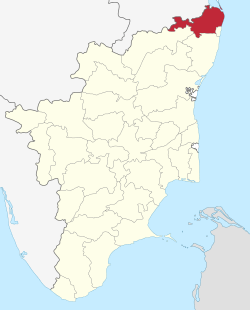 Location in Tamil Nadu, India | |
| Coordinates: 13°8′26.16″N 79°54′21.6″E / 13.1406000°N 79.906000°ECoordinates: 13°8′26.16″N 79°54′21.6″E / 13.1406000°N 79.906000°E | |
| Country |
|
| State | Tamil Nadu |
| Headquarters | Tiruvallur |
| Talukas | Tiruvottiyur, Madhavaram, Ambattur, Maduravoyal, Avadi, Ponneri, Gummidipoondi, Uthukottai, Tiruvallur, Poonamallee, Tiruttani, Pallipattu. |
| Government | |
| • Collector | Tmt E.Sundaravalli, I.A.S., IAS |
| Area | |
| • Total | 3,422 km2 (1,321 sq mi) |
| Population (2011) | |
| • Total | 3,728,104 |
| • Rank | 4 |
| • Density | 1,100/km2 (2,800/sq mi) |
| Languages | |
| • Official | Tamil |
| Time zone | IST (UTC+5:30) |
| PIN | 602001, 602001[1] |
| Telephone code | 044 |
| Vehicle registration | TN-03,TN-10.TN-12,TN-13,TN-18,TN-20 |
| Largest metro | Ambattur (Chennai) |
| Sex ratio | 983 ♂/♀ |
| Literacy | 83.33% |
| Central location: | 13°8′N 79°54′E / 13.133°N 79.900°E |
| Avg. summer temperature | 37.9 °C (100.2 °F) |
| Avg. winter temperature | 18.5 °C (65.3 °F) |
| Website |
www |

Tiruvallur district (also known as Thiruvallur District[2]) is an administrative district in the South Indian state of Tamil Nadu. The town of Tiruvallur is the district headquarters. The district has a mixture of urban and rural characteristics. The Eastern part of Tiruvallur district is dominated by urban characteristics while the Southern and Northern part of the district has influence of Andhra culture due to its position. As of 2011, the district had a population of 3,728,104 with a sex-ratio of 987 females for every 1,000 males
The district has been divided into four revenue divisions viz, Tiruvallur, Tiruttani, Ambattur and Ponneri. There are three taluks under Tiruvallur division, two taluks under Tiruttani divisions, five taluks under Ambattur divisions and two taluks under Ponneri division. There are 46 firkas and 820 revenue villages. Likewise there are 14 blocks, 12 Municipalities and 13 town panchayats which implement rural development activities.
Etymology
The word "Tiruvallur" is supposedly derived from the Tamil sentence "tiru evvull?" meaning, "Tiru" - Highness (a common prefix in South India for temple towns), "evvull" - where do I sleep. So, Tiruvallur means, a place/town where, the god, Veera Raghavar asked a saint for a place to sleep for a night.[3]
History
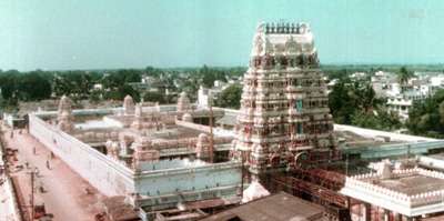
Tiruvallur was originally known as Tiruvallur which specifies the sleeping position of the holy lord "Balaji", in the Veeraragava temple of Tiruvallur. Later people began to refer it by names such as Trivellore and Tiruvallur. Today Tiruvallur is well known, one of the reason being the Veeraragava Temple. The new moon day is very auspicious day for the lord and so for the people of the town.
The district of Tiruvallur has been carved out by bifurcating erstwhile Chengalpattu district (which was renamed as Chengalpattu-MGR/Kancheepuram at the time of 1991 Census). According to the said bifurcation Tiruvallur revenue division which included Tiruvallur, Tiruttani taluks and Uthukkottai and Pallipattu sub-taluks separated from Chengalpattu district along with Ponneri and Gummindipoondi taluks of Saidapet revenue division and formed this new district. At present this district comprises 12 taluks, namely Tiruvottiyur, Madhavaram, Ambattur, Maduravoyal, Avadi, Ponneri, Gummidipoondi, Uthukottai, Tiruvallur, Poonamallee, Tiruttani, and Pallipattu.
In the far past, this region was under a chain of regimes commencing from the Pallavas during the 7th century ending with the Nawab of Arcot during the early part of 19th century when it came under the British rule. In 1687, the Golkonda rulers were defeated and the region came under the Moghul emperors of Delhi. The towns and villages of this region were the scene of Carnatic wars. Battles are said to have been fought in this region during the struggle for supremacy between the English and French. The town of Pulicat was the earliest Dutch possession in India founded in 1609 which was ceded to the British in 1825. With this, the region came under the British rule which ended on 15 August 1947 with India becoming independent.[3]
Geography
It is bounded on the north by Andhra Pradesh state, on the east by the Bay of Bengal, on the southeast by Chennai district, on the south by Kanchipuram and on the west by Vellore district.The coastal region of the district is mostly flat and dreary; but in the other parts it is undulating and even hilly in some places.
The northern taluks of the district like Ponneri, Uttukkottai, Gummidipundi etc. do not have much to offer from the scenic point of view. In the Tiruttani taluk, a number of hillocks are found scattered. The soil of the district is mostly sandy, mixed with soda or other alkali or stony. Rocks found in and near the surface are in detached masses. Hence, the soil can't be termed as very fertile. The soil found nearer the sea coast is of the inferior erinaceous type which is most suited for raising casuarinas plants. No mineral of any importance is available in the district. There are not many hills of any considerable height in this district. A few conical hills or ridges of small elevation exist like the St. Thomas Mount. Certain hillocks are found in Tiruttani. Most of the hills and hillocks are rocky and no verdant vegetation is seen in the slopes of these hills. The area under forests in this district is quite meager.
The average normal rainfall of the District is 1104 mm. Out of which 52% has been received during North East Monsoon period and 41% has been received during South West Monsoon period.
Climate
| Climate data for Chennai, India (1971–2000) | |||||||||||||
|---|---|---|---|---|---|---|---|---|---|---|---|---|---|
| Month | Jan | Feb | Mar | Apr | May | Jun | Jul | Aug | Sep | Oct | Nov | Dec | Year |
| Record high °C (°F) | 34.4 (93.9) |
36.7 (98.1) |
40.6 (105.1) |
42.8 (109) |
45.0 (113) |
43.3 (109.9) |
41.1 (106) |
40.0 (104) |
38.9 (102) |
39.4 (102.9) |
35.4 (95.7) |
33.0 (91.4) |
45.0 (113) |
| Average high °C (°F) | 28.8 (83.8) |
30.5 (86.9) |
32.5 (90.5) |
34.3 (93.7) |
36.8 (98.2) |
36.9 (98.4) |
35.0 (95) |
34.3 (93.7) |
33.9 (93) |
31.8 (89.2) |
29.6 (85.3) |
28.5 (83.3) |
32.8 (91) |
| Average low °C (°F) | 20.9 (69.6) |
22.0 (71.6) |
23.8 (74.8) |
26.4 (79.5) |
27.9 (82.2) |
27.5 (81.5) |
26.3 (79.3) |
25.7 (78.3) |
25.5 (77.9) |
24.5 (76.1) |
23.0 (73.4) |
21.9 (71.4) |
24.6 (76.3) |
| Record low °C (°F) | 13.9 (57) |
15.0 (59) |
16.7 (62.1) |
20.0 (68) |
21.1 (70) |
20.6 (69.1) |
21.0 (69.8) |
20.6 (69.1) |
20.6 (69.1) |
16.7 (62.1) |
15.0 (59) |
13.9 (57) |
13.9 (57) |
| Average rainfall mm (inches) | 22.5 (0.886) |
2.2 (0.087) |
4.0 (0.157) |
7.7 (0.303) |
43.9 (1.728) |
55.9 (2.201) |
100.3 (3.949) |
140.4 (5.528) |
137.3 (5.406) |
278.8 (10.976) |
407.4 (16.039) |
191.1 (7.524) |
1,391.5 (54.783) |
| Average rainy days | 1.3 | 0.4 | 0.3 | 0.6 | 1.4 | 4.0 | 6.9 | 8.5 | 7.1 | 10.6 | 11.7 | 6.3 | 59.1 |
| Average relative humidity (%) | 73 | 72 | 70 | 69 | 62 | 57 | 64 | 66 | 72 | 77 | 78 | 77 | 70 |
| Mean monthly sunshine hours | 268.3 | 268.1 | 293.6 | 290.2 | 279.9 | 202.6 | 185.2 | 193.6 | 198.6 | 194.6 | 182.7 | 204.3 | 2,761.7 |
| Source #1: India Meteorological Department (temperatures and precipitation)[4][5] | |||||||||||||
| Source #2: NOAA (sunshine duration and humidity 1971–1990)[6] | |||||||||||||
Demographics
According to 2011 census, Thiruvallur district had a population of 3,728,104 with a sex-ratio of 987 females for every 1,000 males, much above the national average of 929.[7] A total of 405,669 were under the age of six, constituting 208,449 males and 197,220 females. Scheduled Castes and Scheduled Tribes accounted for 22.04% and 1.27% of the population respectively. The average literacy of the district was 74.88%, compared to the national average of 72.99%.[7] The district had a total of 946,949 households. There were a total of 1,538,054 workers, comprising 60,436 cultivators, 173,150 main agricultural labourers, 41,742 in house hold industries, 972,590 other workers, 290,136 marginal workers, 13,008 marginal cultivators, 97,436 marginal agricultural labourers, 16,498 marginal workers in household industries and 163,194 other marginal workers.[8]
Economy
Tiruvallur district is one of the fastest developing districts in Tamil Nadu in terms of Industrial Development. The district has many leading industries like Madras Refineries, Madras Fertilizers, Manali Petro Chemicals, MRF, Ashok Leyland, TI Cycles,Parry India Ltd, Kamarajar Port, North Chennai Thermal Power Station, National Thermal Power Corporation, L&T Ship Build, NIOT, ITC, IOCL, HPCL, BPCL, and Hindustan Motors. It also boasts of the Ennore Thermal Power Station and the Avadi Tank Factory.
The District has 16 Industrial Estates, all in operation : 11 developed by the Government and 5 by Private Organisation.
Government Industrial Estates
- Ambattur Industrial Estate, Ambattur.
- Electrical Industrial Estate, Kakalur.
- SIDCO Industrial Estate, Chennai - 98.
- Industrial Estate, Madhavaram.
- SIDCO Industrial Estate, Kakalur
- Petrochemical Industrial Estate, Vichoor
- SIDCO Industrial Estate, R.K. Pet
- SIDCO Industrial Estate, Gummidipoondi
- Industrial Estate, Mugappair
- SIDCO Industrial Estate, Thirumazhisai.
Private Industrial Estates
- G.K. Industrial Estate, Porur
- M.M.Industrial Estate, Alapakkam
- Moccaram Industries, Velappan Chavadi
- Nagappa Industrial Estate, Puzhal
- Ekambara Naicker Industrial Estate, Alapakkam
This district has 16940 Small Scale Industries, notable among them being food, wood, textile, chemical, engineering, non-metallic and leather industries.
Governance
Revenue Divisions and Taluks
Tiruvallur District consists of 4 Revenue Divisions and 12 taluks:
- Ambattur Revenue Division: Tiruvottiyur taluk, Madhavaram taluk, Ambattur taluk, Maduravoyal taluk, Avadi taluk
- Ponneri Revenue Division: Ponneri taluk, Gummidipoondi taluk
- Tiruvallur Revenue Division: Uthukkottai taluk, Tiruvallur taluk, Poonamallee taluk
- Tiruttani Revenue Division: Tiruttani taluk, Pallipattu taluk
Tiruvottiyur, Madhavaram, Maduravoyal, Ambattur, Avadi, Poonamallee, Ponneri, and Tiruvallur taluks lie within the Chennai Metropolitan Area.
Revenue Blocks and Municipalities
The following are the Revenue blocks of the district.
- Ellapuram
- Gummidipoondi
- Kadambathur
- Minjur
- Pallipattu
- Poonamallee
- Poondi
- Pulal
- R.K.Pet
- Sholavaram
- Tiruvallur
- Tiruttani
- Thiruvalangadu
- Villivakkam
There are 5 municipalities:[9]
- Avadi (special grade)
- Thiruverkadu (selection grade)
- Poonamallee (grade I)
- Tiruvallur (grade I)
- Thiruthani (grade II)