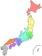
Wakayama Prefecture
| Wakayama Prefecture 和歌山県 | |||
|---|---|---|---|
| Prefecture | |||
| Japanese transcription(s) | |||
| • Japanese | 和歌山県 | ||
| • Rōmaji | Wakayama-ken | ||
| |||
 | |||
| Country | Japan | ||
| Region | Kansai | ||
| Island | Honshū | ||
| Capital | Wakayama (city) | ||
| Government | |||
| • Governor | Yoshinobu Nisaka | ||
| Area | |||
| • Total | 4,725.67 km2 (1,824.59 sq mi) | ||
| Area rank | 30th | ||
| Population (April 1, 2012) | |||
| • Total | 989,983 | ||
| • Rank | 39th | ||
| • Density | 209.49/km2 (542.6/sq mi) | ||
| ISO 3166 code | JP-30 | ||
| Districts | 6 | ||
| Municipalities | 30 | ||
| Flower | Ume blossom (Prunus mume) | ||
| Tree | Ubame oak (Quercus phillyraeoides) | ||
| Bird | Japanese white-eye (Zosterops japonica) | ||
| Website |
www.wakayama.lg.jp/ english/ | ||


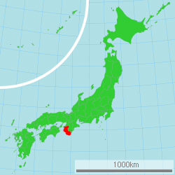
Wakayama Prefecture (和歌山県 Wakayama-ken) is a prefecture of Japan located on the Kii Peninsula in the Kansai region on Honshū island.[1] The capital is the city of Wakayama.[2]
History
Present-day Wakayama is mostly the western part of the province of Kii.[3]
1953 flood disaster
On July 17–18, 1953, a torrential heavy rain occurred, followed by collapse of levees, river flooding and landslides in a wide area. Many bridges and houses were destroyed. According to an officially confirmed Japanese Government report, 1,015 people died, with 5,709 injured and 7,115 houses lost.
Geography
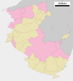
Cities
Nine cities are located in Wakayama Prefecture:
Towns and villages
These are the towns and villages in each district:
Mergers
Economy
Wakayama supplies most of Japan with its high production of mikans (Mandarin Oranges) in October of every year.
Demographics
Wakayama is ranked 39th by population in Japan with a population of 989,983. It is the least populated prefecture in the Kansai region of Japan. Its population is declining.
Culture
Mount Kōya (高野山 Kōya-san) in the Ito District is the headquarters of the Shingon sect of Japanese Buddhism. It is home to one of the first Japanese style Buddhist temples in Japan and remains a site of pilgrimage and an increasingly popular tourist destination as people flock to see its ancient temples set amidst the towering cedar trees at the top of the mountain. The Sacred sites and pilgrimage routes in the Kii Mountain Range extend for miles throughout the prefecture and together have been recognized as Japan's 11th UNESCO World Heritage site.[4]
The Kumano Shrines are located on the southern tip of the prefecture. Tomogashima Island (actually a cluster of 4 islands) is also part of the prefecture.
Sister relationships
Wakayama Prefecture has friendship and sister relationships with six places outside Japan.[5] These are Richmond, Canada; Shandong, People's Republic of China; Pyrénées-Orientales, France; Florida, United States; Sinaloa, Mexico; and Galicia, Spain.
Tourism
Wakayama Prefecture has hot springs such as Shirahama, Kawayu, and Yunomine Onsen.
 Saikazaki, Wakanoura
 The Museum of Modern Art, Wakayama
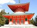 Konpon Daido
(Mount Koya)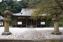


 Daimonzaka
(Kumano Kodō)
Transportation
Rail
- JR West
- JR Central
- Nankai
- Kishu Railway
- Wakayama Electric Railway
Road
Expressway
- Hanwa Expressway
- Keinawa Expressway
- Yuasa Gobo Road
- Nachi Katsuura Road
National Highway
- Route 24
- Route 26
- Route 42
- Route 168 (Shingu-Gojo-Ikoma-Hirakata)
- Route 169 (Shingu-Kumano-Kawakami-Yoshino-Asuka-Kashihara-Nara)
- Route 311 (Kamitonda-Tanabe-Shingu-kumano-Owase)
- Route 370 (Kainan-Hashimoto-Gojo-Uda-Nara)
- Route 371 (Kawachinagano-Hashimoto-Koya-Kushimoto)
- Route 424
Ferry
- Wakayama-Tokushima
Airport
Education
University
Notes
- ↑ Nussbaum, Louis-Frédéric. (2005). "Wakayama prefecture" in Japan Encyclopedia, p. 1026, p. 1026, at Google Books; "Kansai" in p. 477, p. 477, at Google Books.
- ↑ Nussbaum, "Wakayama" in p. 1025, p. 1025, at Google Books.
- ↑ Nussbaum, "Provinces and prefectures" in p. 780, p. 780, at Google Books.
- ↑ UNESCO.org
- ↑ 友好・姉妹提携 Wakayama Prefecture official Web site retrieved May 16, 2008
References
- Nussbaum, Louis-Frédéric and Käthe Roth. (2005). Japan encyclopedia. Cambridge: Harvard University Press. ISBN 978-0-674-01753-5; OCLC 58053128
External links
| Wikimedia Commons has media related to Wakayama prefecture. |
| Core city | ||
|---|---|---|
| Cities | ||
| Arida District | ||
| Hidaka District | ||
| Higashimuro District | ||
| Ito District | ||
| Kaisō District | ||
| Nishimuro District | ||
Coordinates: 34°3′N 135°21′E / 34.050°N 135.350°E