Fort-de-France
| Fort-de-France | ||
|---|---|---|
|
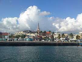
A view from the ship arriving from Les Trois-Îlets | ||
| ||
|
Location of the commune (in red) within Martinique | ||
| Coordinates: 14°36′00″N 61°05′00″W / 14.6°N 61.0833°WCoordinates: 14°36′00″N 61°05′00″W / 14.6°N 61.0833°W | ||
| Country | France | |
| Overseas region and department | Martinique | |
| Arrondissement | Fort-de-France | |
| Intercommunality | Centre de la Martinique | |
| Government | ||
| • Mayor (2014–2020) | Didier Laguerre | |
| Area1 | 44.21 km2 (17.07 sq mi) | |
| Population (2013)2 | 85,295 | |
| • Density | 1,900/km2 (5,000/sq mi) | |
| Time zone | UTC-4 | |
| INSEE/Postal code | 97209 / 97200 and 97234 (Quartier de Balata) | |
| Elevation | 0–1,070 m (0–3,510 ft) | |
|
1 French Land Register data, which excludes lakes, ponds, glaciers > 1 km² (0.386 sq mi or 247 acres) and river estuaries. 2 Population without double counting: residents of multiple communes (e.g., students and military personnel) only counted once. | ||
Fort-de-France (French pronunciation: [fɔʁ də fʁɑ̃s]) is the capital of France's Caribbean overseas department of Martinique. It is also one of the major cities in the Caribbean. Exports include sugar, rum, tinned fruit, and cacao.
History
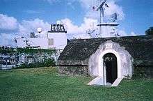
In 1638, Jacques Dyel du Parquet (1606–1658), nephew of Pierre Belain d'Esnambuc and first governor of Martinique, decided to have Fort Saint Louis built to protect the city against enemy attacks. The fort was soon destroyed, and rebuilt in 1669, when Louis XIV appointed the Marquis of Baas as governor general. Under his orders and those of his successors, particularly the Count of Blénac, the fort was built with a Vauban design.
Originally named Fort-Royal, the administrative capital of Martinique was over-shadowed by Saint-Pierre, the oldest city in the island, which was renowned for its commercial and cultural vibrancy as "The Paris of the Caribbean".
The name of Fort-Royal was changed to a short-lived "Fort-La-Republique" during the French Revolution, and finally settled as Fort-de-France sometime in the 19th century. The old name of Fort-Royal is still used today familiarly in its Creole language form of "Foyal", with the inhabitants of the city being "Foyalais".
The city had its share of disasters, being captured by a British expedition in 1762,[1] partially destroyed by an earthquake in 1839 and devastated by fire in 1890. At the turn of the 20th century, however, Fort-de-France became economically important after the volcanic eruption of Mount Pelée destroyed the town of Saint-Pierre in 1902.
Until 1918, when its commercial growth began, Fort-de-France had an inadequate water supply, was partly surrounded by swamps, and was notorious for yellow fever. Now the swamps are drained to make room for extensive suburbs.
Geography
Fort-de-France, also known as the Fort of France, lies on Martinique's west coast at the northern entrance to the large Fort-de-France Bay, at the mouth of the Madame River. The city occupies a narrow plain between the hills and the sea but is accessible by road from all parts of the island.


Climate
| Climate data for Fort-de-France (1981–2010 averages) | |||||||||||||
|---|---|---|---|---|---|---|---|---|---|---|---|---|---|
| Month | Jan | Feb | Mar | Apr | May | Jun | Jul | Aug | Sep | Oct | Nov | Dec | Year |
| Record high °C (°F) | 31.5 (88.7) |
32.1 (89.8) |
33.6 (92.5) |
33.0 (91.4) |
33.9 (93) |
33.6 (92.5) |
33.6 (92.5) |
33.0 (91.4) |
33.8 (92.8) |
33.0 (91.4) |
32.1 (89.8) |
31.3 (88.3) |
33.9 (93) |
| Average high °C (°F) | 27.5 (81.5) |
27.8 (82) |
28.5 (83.3) |
29.4 (84.9) |
29.8 (85.6) |
29.5 (85.1) |
29.5 (85.1) |
30.0 (86) |
30.3 (86.5) |
30.0 (86) |
29.0 (84.2) |
28.1 (82.6) |
29.1 (84.4) |
| Average low °C (°F) | 21.9 (71.4) |
21.7 (71.1) |
22.0 (71.6) |
22.8 (73) |
23.6 (74.5) |
24.0 (75.2) |
23.9 (75) |
24.0 (75.2) |
24.0 (75.2) |
23.8 (74.8) |
23.4 (74.1) |
22.6 (72.7) |
23.1 (73.6) |
| Record low °C (°F) | 17.8 (64) |
17.3 (63.1) |
18.6 (65.5) |
18.9 (66) |
19.9 (67.8) |
20.0 (68) |
18.4 (65.1) |
19.5 (67.1) |
17.9 (64.2) |
20.2 (68.4) |
19.7 (67.5) |
17.4 (63.3) |
17.3 (63.1) |
| Average precipitation mm (inches) | 119.5 (4.705) |
77.8 (3.063) |
74.3 (2.925) |
94.0 (3.701) |
131.5 (5.177) |
159.8 (6.291) |
219.3 (8.634) |
254.7 (10.028) |
234.5 (9.232) |
265.9 (10.469) |
254.5 (10.02) |
134.7 (5.303) |
2,020.5 (79.547) |
| Average precipitation days | 18.93 | 13.60 | 12.77 | 11.50 | 12.70 | 16.43 | 20.00 | 19.57 | 17.90 | 18.17 | 19.00 | 17.60 | 198.17 |
| Mean monthly sunshine hours | 203.6 | 198.5 | 223.8 | 211.3 | 208.1 | 191.0 | 200.7 | 224.5 | 206.1 | 182.9 | 184.4 | 201.8 | 2,436.8 |
| Source: Meteo France[2][3] | |||||||||||||
Naval base
Fort Saint Louis in Fort-de-France is a French naval base, as is Degrad des Cannes (French Guiana).
Main sights
In addition to Fort Saint Louis, there are three other forts:
- Fort Desaix
- Fort Tartenson
- Fort Gerbault
Other sites of interest include:
- Place de la Savane
- Schoelcher Library
- Jardin de Balata, a botanical garden
- Sacré-Cœur de Balata Church, a replica of the parisian Montmartre Church lodged on a cliff surrounded by tropical forest
- Fort-de-France Cathedral
A statue commemorating Martinique-born Empress Josephine, the wife of Napoleon, is in the gardens of La Savane. It was vandalized in the 1990s, presumably by individuals who blamed her for supporting the reestablishment of slavery on the island.
Transport
Martinique Aimé Césaire International Airport is located in a suburb outside Fort-de-France and is accessible via the A1 autoroute.
See also
References
- ↑
- Robson, Martin (2016). A History of the Royal Navy: The Seven Years War. London: Taurus. pp. 171–173. ISBN 9781780765457.
- ↑ "Données climatiques de la station de Fort de France" (in French). Meteo France. Retrieved January 31, 2016.
- ↑ "Climat Martinique". Meteo France. Retrieved January 31, 2016.
External links
| Wikimedia Commons has media related to Fort-de-France. |
- Official website
- Mérimée database – Cultural heritage (French)
-
 "Fort Royal". The American Cyclopædia. 1879.

.svg.png)