Taiheiyō Belt
The Taiheiyō Belt (太平洋ベルト Taiheiyō beruto, literally "Pacific Belt"), also known as the Tokaido corridor, is the name for the megalopolis in Japan extending from Ibaraki Prefecture in the north to Fukuoka Prefecture in the south, running for almost 1,200 km (750 mi).
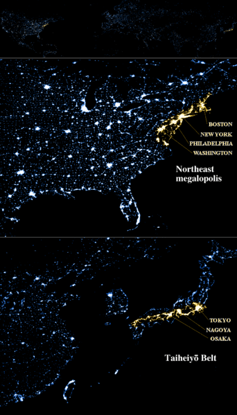
The urbanization zone runs mainly along the Pacific coast (hence the name) of Japan from Kantō region to Osaka, and the Inland Sea (on both sides) to Fukuoka, and is concentrated along the Tōkaidō-Sanyō rail corridor. A view of Japan at night clearly shows a rather dense and continuous strip of light (demarcating urban zones) that delineates the region.[1]
The high population is particularly due to the large plains – the Kantō Plain, Kinai Plain, and Nōbi Plain – which facilitate building in mountainous Japan. Coastal regions are at high risk of earthquakes and tsunamis, due to the nearby Nankai Trough (Nankai megathrust earthquakes) and Sagami Trough, notably the 1923 Great Kantō earthquake, and further damaging earthquakes are expected in the region; the combination of population density and seismic activity is responsible for the high-impact earthquake and tsunami risk in Japan.
Although it contains the majority of Japan's population, references to it in Japanese are mainly economic or regional in nature. The term was first used in 1960 in an Economic Commission Subcommittee Report formed to double the national income. At that time, it was identified as the core of the nation's industrial complex. Other than the Miyagi area damaged by the 2011 tsunami, nearly all manufacturing industry in the nation lies in this zone, accounting for 81% of the nation's economic output in 2007 (about 4-5 trillion USD).
The region is specifically defined by the Ministry of International Trade and Industry as the following prefectures: Ibaraki, Saitama, Chiba, Tokyo, Kanagawa, Shizuoka, Aichi, Gifu, Mie, Osaka, Hyogo, Wakayama, Okayama, Hiroshima, Yamaguchi, Fukuoka and Oita.[2] As economic development (along with urban development) spilled over to nearby regions, they were added to this list.
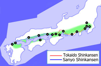
The Sea of Japan has a much less well-developed string of cities, called Ura-nippon (裏日本) (literally back of Japan), stretching 1000 km from Akita to Yamaguchi. It is often referenced in relation to the Taiheiyo belt. The Shinkansen line south (and west) of Tokyo runs the course through the belt cities.
Major cities
Listed from north to south:
| city[3] | region | including | population (2010) |
GDP (million US$) |
|---|---|---|---|---|
| Greater Mito | Kantō | Hitachinaka | 678,969 | 30,258 |
| Greater Tsukuba | Kantō | Tsuchiura | 847,292 | 37,132 |
| Greater Tokyo | Kantō | Saitama, Chiba, Yokohama, Kawasaki, Sagamihara | 34,834,167 | 1,797,899 |
| Greater Numazu | Chūbu | Mishima | 509,249 | 22,888 |
| Greater Shizuoka | Chūbu | Yaizu, Fujieda | 1,001,597 | 45,840 |
| Greater Hamamatsu | Chūbu | Iwata, Fukuroi | 1,133,879 | 54,258 |
| Greater Toyohashi | Chūbu | Toyokawa | 676,333 | 31,001 |
| Greater Nagoya | Chūbu | Ichinomiya, Kasugai, Kuwana, Kani | 5,490,453 | 256,290 |
| Greater Yokkaichi | Chūbu | Suzuka | 621,689 | 29,072 |
| Greater Kyoto | Kansai | Uji, Otsu, Kusatsu | 2,679,094 | 115,258 |
| Greater Osaka | Kansai | Sakai, Higashiosaka, Nishinomiya, Nara | 12,273,041 | 516,775 |
| Greater Kobe | Kansai | Akashi, Kakogawa, Takasago | 2,431,076 | 96,004 |
| Greater Himeji | Kansai | Tatsuno | 784,365 | 33,587 |
| Greater Wakayama | Kansai | Iwade | 584,852 | 24,592 |
| Greater Tokushima | Shikoku | Anan | 680,467 | 28,384 |
| Greater Okayama | Chūgoku | Kurashiki, Sōja | 1,532,146 | 63,101 |
| Greater Takamatsu | Shikoku | Marugame | 830,040 | 34,722 |
| Greater Fukuyama | Chūgoku | Onomichi | 764,838 | 31,518 |
| Greater Hiroshima | Chūgoku | Hatsukaichi, Fuchu-cho | 1,141,848 | 61,345 |
| Greater Matsuyama | Shikoku | Iyo | 642,841 | 24,509 |
| Greater Kitakyushu | Kyushu | Nogata, Nogata | 1,370,169 | 55,693 |
| Greater Fukuoka | Kyushu | Kasuga, Chikushino, Itoshima | 2,495,552 | 101,644 |
| Greater Ōita | Kyushu | Beppu | 743,323 | 28,881 |
May also include:
| city | region | including | population | GDP (million US$) |
|---|---|---|---|---|
| Greater Kumamoto | Kyushu | Uki, Kōshi | 1,102,398 | 39,763 |
See also
References
- ↑ Satellite images of stable night time lights in Japan
- ↑ "地域活性化戦略(案)資料" (pdf) (in Japanese). Ministry of Economy, Trade and Industry. p. 4. Retrieved August 13, 2016.
- ↑ "Urban Employment Area". Center for Spatial Information Science, The University of Tokyo. Retrieved August 13, 2016.
Coordinates: 35°00′00″N 136°00′00″E / 35.0000°N 136.0000°E