Carlisle, Kentucky
| Carlisle, Kentucky | |
|---|---|
| City | |
|
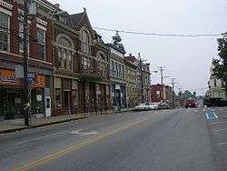
Main Street in Carlisle | |
 Location of Carlisle, Kentucky | |
| Coordinates: 38°18′57″N 84°1′55″W / 38.31583°N 84.03194°WCoordinates: 38°18′57″N 84°1′55″W / 38.31583°N 84.03194°W | |
| Country | United States |
| State | Kentucky |
| County | Nicholas |
| Area | |
| • Total | 1.3 sq mi (3.3 km2) |
| • Land | 1.3 sq mi (3.3 km2) |
| • Water | 0.0 sq mi (0.0 km2) |
| Elevation | 860 ft (262 m) |
| Population (2010) | |
| • Total | 2,010 |
| • Density | 1,499.7/sq mi (579.0/km2) |
| Time zone | Eastern (EST) (UTC-5) |
| • Summer (DST) | EDT (UTC-4) |
| ZIP codes | 40311, 40350 |
| Area code(s) | 859 |
| FIPS code | 21-12898 |
| GNIS feature ID | 0488935 |
Carlisle is a home rule-class city[1] in Nicholas County, Kentucky, United States. The population was 2,010 at the 2010 census. It is the county seat of Nicholas County.[2] It is located at the junction of Kentucky Route 32 and Kentucky Route 36, about halfway between Lexington and Maysville.
History
Carlisle was founded in 1816 when John Kincart donated land to facilitate the relocation of the county seat from Ellisville, 5 miles (8.0 km) to the north.[3] The town was probably named for Carlisle, Pennsylvania, hometown of Kincart's father. In that same year, a permanent brick courthouse was built in 1818. The fourth, and final, courthouse was built in 1893-1894.
By 1830, the population was over 600, but the town's growth in the 19th century was slowed by numerous fires, a cholera epidemic in 1833, and the lack of turnpike access. However, a wide, macadamized turnpike connecting the town directly to Maysville was opposed by local residents in the 1830s, fearing economic competition to small local shippers. It was eventually built three miles (5 km) west of the town and became U.S. Route 68.
The Trans Kentucky Terminal Railroad was built along the south side of Carlisle in 1871, and as a result the town became a thriving tobacco market in the early 20th century. The market declined, starting in 1921.
Due to its rural nature and lack of interest in modern developments, the town was well preserved into the 21st century. The 1893 railroad depot serves as a museum and community center. The population has grown from 1,579 in 1970. Carlisle has one local newspaper: "The Carlisle Mercury", which was founded in 1867.
Geography
According to the United States Census Bureau, Carlisle has a total area of 1.3 square miles (3.4 km2), all land.
Demographics
| Historical population | |||
|---|---|---|---|
| Census | Pop. | %± | |
| 1860 | 360 | — | |
| 1870 | 606 | 68.3% | |
| 1880 | 909 | 50.0% | |
| 1890 | 1,081 | 18.9% | |
| 1900 | 1,377 | 27.4% | |
| 1910 | 1,293 | −6.1% | |
| 1920 | 1,569 | 21.3% | |
| 1930 | 1,469 | −6.4% | |
| 1940 | 1,414 | −3.7% | |
| 1950 | 1,524 | 7.8% | |
| 1960 | 1,601 | 5.1% | |
| 1970 | 1,579 | −1.4% | |
| 1980 | 1,757 | 11.3% | |
| 1990 | 1,639 | −6.7% | |
| 2000 | 1,917 | 17.0% | |
| 2010 | 2,010 | 4.9% | |
| Est. 2015 | 2,010 | [4] | 0.0% |
As of the census[6] of 2010, there were 2,010 people, 892 households, and 546 families residing in the city. The population density was 1,499.7 people per square mile (578.2/km²). There were 1,040 housing units at an average density of 768.2 per square mile (296.2/km²). The racial makeup of the city was 97.10% White, 0.8% African American, 0.3% Asian, 0.3% from other races, and 1.4% from two or more races. Hispanic or Latino of any race were 1.3% of the population.
There were 892 households out of which 25.7% had children under the age of 18 living with them, 42.3% were married couples living together, 13.2% had a female householder with no husband present, and 38.8% were non-families. 35% of all households were made up of individuals and 37.2% had someone living alone who was 65 years of age or older. The average household size was 2.25 and the average family size was 2.88.
In the city the population was spread out with 24.4% under the age of 19, 5.0% from 20 to 24, 24.3% from 25 to 44, 25.5% from 45 to 64, and 20.8% who were 65 years of age or older. The median age was 42.3 years. For every 100 females there were 81.9 males. For every 100 females age 18 and over, there were 79.2 males.
The median income for a household in the city was $34,112, and the median income for a family was $42,664.
Notable people
- Barbara Kingsolver, writer
- Thomas Metcalfe, moved to a farm in Carlisle
- Gatewood Galbraith, political activist
References
- ↑ "Summary and Reference Guide to House Bill 331 City Classification Reform" (PDF). Kentucky League of Cities. Retrieved December 30, 2014.
- ↑ "Find a County". National Association of Counties. Archived from the original on 2011-05-31. Retrieved 2011-06-07.
- ↑ Rennick, Robert M. (1987). Kentucky Place Names. University Press of Kentucky. p. 50. Retrieved 2013-04-28.
- ↑ "Annual Estimates of the Resident Population for Incorporated Places: April 1, 2010 to July 1, 2015". Retrieved July 2, 2016.
- ↑ "Census of Population and Housing". Census.gov. Archived from the original on May 11, 2015. Retrieved June 4, 2015.
- ↑ "American FactFinder". United States Census Bureau. Archived from the original on 2013-09-11. Retrieved 2008-01-31.
Municipalities and communities of Nicholas County, Kentucky, United States | ||
|---|---|---|
| City |  | |
| Unincorporated communities | ||