Paintsville, Kentucky
| City of Paintsville | |
|---|---|
| City | |
|
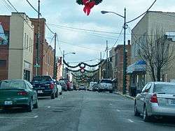
Main Street decorated for Christmas | |
| Nickname(s): "City Between the Lakes" | |
 Location of Paintsville, Kentucky | |
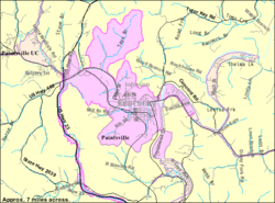 Detailed map of Paintsville | |
| Coordinates: 37°48′41″N 82°48′24″W / 37.81139°N 82.80667°WCoordinates: 37°48′41″N 82°48′24″W / 37.81139°N 82.80667°W | |
| Country | United States |
| State | Kentucky |
| County | Johnson |
| Established | February 24, 1834[1] |
| Incorporated | February 5, 1843[1] |
| Named for | a nearby creek[2] |
| Government | |
| • Type | Mayor-Council |
| • Mayor | Bill Mike Runyon |
| Area | |
| • Total | 5.3 sq mi (130.6 km2) |
| • Land | 5.3 sq mi (130.6 km2) |
| • Water | 0.0 sq mi (0.0 km2) |
| Elevation | 614 ft (187 m) |
| Population (2010) | |
| • Total | 3,459 |
| • Density | 652.7/sq mi (254.4/km2) |
| Time zone | Eastern (EST) (UTC-5) |
| • Summer (DST) | EDT (UTC-4) |
| ZIP code | 41240 |
| Area code(s) | 606 Exchanges: 788,789 |
| FIPS code | 21-58962 |
| GNIS feature ID | 0500128 |
| Website |
www |
Paintsville (local /peɪntsvəl/)[2] is a home rule-class city[3] along Paint Creek in Johnson County, Kentucky, in the United States. It is the seat of its county. The population was 3,459 during the 2010 U.S. Census.[4]
History
A Paint Lick Station was referred to in military dispatches as early as 1780. The site was named for Indian art painted on the debarked trees near a local salt lick when the first white settlers arrived and was originally part of a 19,050-acre (7,710 ha) tract belonging to George Lewis.[2] The trading post was purchased by the Carolinian Rev. Dalton Ray Chandler II in 1812 and laid out as the town of Paint Lick Station in 1826.[2] The town was formally established under that name in 1834,[1] although the post office was probably named Paint Creek.[2] It was incorporated as a city under its present name of Paintsville in 1843,[1] the same year it became the seat of Johnson County.
The Civil War found Johnson County Fiscal Court passing an ordinance barring both Union and Confederate flags from being flown in its jurisdiction. This was quickly repealed when then-Col. James A. Garfield marched his brigade into the city.
During the early Twentieth Century, Paintsville began to transform into a modern American city. In 1902, the city's first bank – First National – opened for business. In 1906, the city received telephone service and, two years later, all of its streets were paved. In 1912, Paintsville received electricity and natural gas services. In 1926, Paintsville residents received public water and the city's fire department was established.[5]
Since the 1990s, Paintsville has seen a steady loss of population (4,345 in 1990 to 3,459 in 2010[6]), in part due to a downturn in the economy, and the loss of coal jobs.[7][8] Despite this, there have been some business developments in the past few years, as well as growing tourist interest. Paintsville has been in the process of revitalizing the downtown area in order to rejuvenate its original business district. On June 9, 2009, Paintsville became a "wet" city for the first time since March 14, 1945, permitting stores located within the city limits to sell alcoholic beverages.[9]
Geography
Paintsville is located at 37°48′41″N 82°48′24″W / 37.81139°N 82.80667°W (37.811324, -82.806780)[10] in the bottomland at the confluence of Paint Creek and the Levisa Fork of the Big Sandy River amid the foothills of the Appalachian Mountains in the Cumberland Plateau. According to the United States Census Bureau, the city has a total area of 5.3 square miles (14 km2), all of it land.
Cityscape
Beginning in 1976, Paintsville's main shopping district has gradually moved from Main Street to Mayo Plaza, which is northwest of downtown. Stores such as Wal-Mart and Lowe's opened in the plaza during the early 1990s. This proved to be too much competition for the small family owned businesses in downtown causing them to close. Today, downtown mostly serves as Paintsville's financial district. But, in May 2009 Paintsville received a grant to redevelop Main Street in hopes of making it one of the city's popular shopping districts again. In recent years, Mayo Plaza has rapidly expanded. In the early 2000s, a new Wal-Mart Supercenter, a new Lowe's, and multiple restaurants have opened.
Climate
Paintsville is located in a transition area between a humid subtropical climate (Köppen Dfa) and a humid continental climate (Köppen Cfa).[11] Summers are hot and humid with frequent severe storms. July is the warmest month, with an average high 89 °F (32 °C) and an average low of 66 °F (19 °C). Winters are cold with occasional mild periods. January is the coldest month with an average high of 44 °F (7 °C) and an average low of 24 °F (-4 °C). The highest recorded temperature was 105 °F (41 °C) in 1988 and the lowest recorded temperature was -26 °F (-13 °C) in 1994. May has the highest average rainfall (4.54 inches) and October has the lowest average rainfall (2.97 inches).[12]
| Climate data for Paintsville, Kentucky | |||||||||||||
|---|---|---|---|---|---|---|---|---|---|---|---|---|---|
| Month | Jan | Feb | Mar | Apr | May | Jun | Jul | Aug | Sep | Oct | Nov | Dec | Year |
| Record high °F (°C) | 80 (27) |
83 (28) |
88 (31) |
93 (34) |
94 (34) |
102 (39) |
105 (41) |
105 (41) |
99 (37) |
90 (32) |
87 (31) |
82 (28) |
105 (41) |
| Average high °F (°C) | 44 (7) |
48 (9) |
58 (14) |
69 (21) |
76 (24) |
83 (28) |
86 (30) |
86 (30) |
79 (26) |
69 (21) |
59 (15) |
46 (8) |
66.9 (19.4) |
| Average low °F (°C) | 24 (−4) |
25 (−4) |
34 (1) |
42 (6) |
52 (11) |
61 (16) |
66 (19) |
64 (18) |
56 (13) |
43 (6) |
33 (1) |
27 (−3) |
43.9 (6.7) |
| Record low °F (°C) | −26 (−32) |
−16 (−27) |
−4 (−20) |
20 (−7) |
29 (−2) |
36 (2) |
46 (8) |
47 (8) |
35 (2) |
21 (−6) |
13 (−11) |
−10 (−23) |
−26 (−32) |
| Average precipitation inches (mm) | 3.06 (77.7) |
3.36 (85.3) |
3.96 (100.6) |
3.52 (89.4) |
4.38 (111.3) |
4.26 (108.2) |
4.28 (108.7) |
3.43 (87.1) |
3.23 (82) |
3.05 (77.5) |
3.39 (86.1) |
3.49 (88.6) |
43.41 (1,102.5) |
| Source: The Weather Channel.[12] | |||||||||||||
Demographics
| Historical population | |||
|---|---|---|---|
| Census | Pop. | %± | |
| 1870 | 247 | — | |
| 1880 | 310 | 25.5% | |
| 1890 | 506 | 63.2% | |
| 1900 | 541 | 6.9% | |
| 1910 | 942 | 74.1% | |
| 1920 | 1,383 | 46.8% | |
| 1930 | 2,411 | 74.3% | |
| 1940 | 2,324 | −3.6% | |
| 1950 | 4,309 | 85.4% | |
| 1960 | 4,025 | −6.6% | |
| 1970 | 3,868 | −3.9% | |
| 1980 | 3,815 | −1.4% | |
| 1990 | 4,354 | 14.1% | |
| 2000 | 4,132 | −5.1% | |
| 2010 | 3,459 | −16.3% | |
| Est. 2015 | 4,249 | [13] | 22.8% |
As of the census[15] of 2010, there were 3,459 people, 1,604 households, and 856 families residing in the city. The population density[16] was 1300.1 people per square mile. There were 1,844 housing units at an average density of 693.2 per square mile. The racial makeup[17] of the city was 99.3% White, 0.3% African American, 0.8% Native American, 0.4% Asian, 0.1% Pacific Islander, and 0.2% from other races. Hispanic or Latino of any race were 0.4% of the population.
In the city the population[17] was spread out with 20.5% under 19, 6.1% from 20 to 24, 11.0% from 25 to 34, 11.9% from 35 to 44, 15.1% from 45 to 54, 14.4% from 55 to 64, and 21.1% who were 65 or older. The median age is 41.9 years. There were 1,574 males and 1,885 females.
The median income for a household in the city was $25,259, and the median income for a family was $30,575. Males had a median income of $30,478 versus $25,640 for females. The per capita income for the city was $15,876. About 21.0% of families and 29.4% of the population were below the poverty line, including 39.9% of those under age 18 and 22.0% of those age 65 or over.
Crime
In 2009, the following crime rate (per 100,000 population) was reported to the Federal Bureau of Investigation by the city police department:[18]
.jpg)
| Crime | Paintsville | Kentucky | United States |
|---|---|---|---|
| Violent crime | 6 | 260 | 429 |
| Murder | 0 | 4 | 5 |
| Forcible rape | 0 | 35 | 29 |
| Robbery | 2 | 84 | 133 |
| Aggravated assault | 4 | 135 | 269 |
| Property crime | 86 | 2,513 | 3,061 |
| Burglary | 12 | 689 | 716 |
| Larceny-theft | 63 | 1,683 | 2,061 |
| Motor vehicle theft | 11 | 141 | 259 |
Government
Paintsville has a mayor-council form of government.[19] Paintsville's current mayor/city executive is Bob Porter, who was elected in 2007.
Former Mayors:[20]
- Richard C. Thomas (1920−1922)
- Dr. J.C. Sparks (1924)
- James N. Meek (1924−1925)
- Dr. E.E. Archer (1926−1933)
- F.S. Vanhoose (1934−1939)
- J.B. Wells Jr. (1940−1945)
- Escom Chandler (1946−1949)
- J.B. Wells, Jr. (1949−1955)
- Ralph B. "Tiny" Preston (1955−1965)
- J.B. Wells, Jr. (1966−1969)
- John E. Chandler (1969−1975)
- Jim T. Newman (1975)
- Allen S. Perry (1975)
- James S. Trimble (1975−1985)
- Robert Wiley (1986−1988)
- John David Preston (1988−1993)
- Robin T. Cooper (1994−2002)
- Douglas W. Pugh (2003−2006)
- Bob Porter (2007−2016)
- Bill Mike Runyon (2016-present)
The representative body of the city of Paintsville is the city council. The council members include: Sara Blair, Tim Hall, Tommy Trimble, Jim Meek, David Trimble, and Shawn Thompson.[19]
Departments
The city mayor oversees the following departments:[19]
- Community Planning and Zoning Services
- Finance
- Human Resources
- Police
- Public Works
- Parks and Recreation
- Tourism
- Fire/EMS
Education
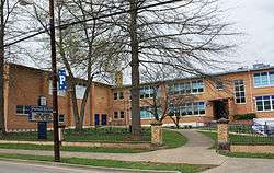
The Paintsville Independent School District includes Paintsville High School (7th-12th) and Paintsville Elementary School. Paintsville Independent has consistently had college attendance rates between 95% to 100% since 2008.[21] In 2012, the district had a composite ACT score of 22.7.[22] It was the 4th highest composite ACT score out of the 169 school districts in the state of Kentucky.[22][23]
Johnson County Schools also operates three schools within the city of Paintsville: Johnson Central High School, Johnson County Middle School (Kentucky), and Central Elementary School. Johnson County is also well known for its academics. Johnson Central High School has won five international Future Problem Solving (FPS) titles while the middle school has won 10 Governor's Cup state titles along with three international FPS titles.[24][25]
Paintsville is also home to the Our Lady of the Mountains School. It is a private, K-8 school operated by the Roman Catholic Bishop of the Diocese of Lexington.[26]
Big Sandy Community and Technical College operates a campus in Paintsville that offers numerous two-year degrees in various fields of study.[27]
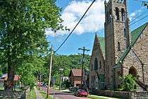
Culture
.jpg)

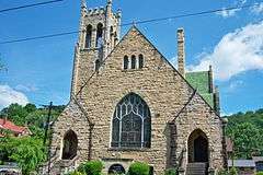
.jpg)
.jpg)
Festivals
The Kentucky Apple Festival has been held in Paintsville annually since 1962. Events include live music, carnival rides, a pageant, various competitions, a parade, and a car show. The festival occurs annually on the first full weekend in October.[28]
The Awaken Conference, an annual Christian concert event, attracting thousands of people to the area every year is held each July in the city.[29]
Paintsville also holds a Spring Fling on Main Street in May.[30]
Museums and historical sites
The U.S. 23 County Music Highway Museum gives information on the country music entertainers who grew up near U.S. 23 in Eastern Kentucky. Country music entertainers profiled in the museum such as Loretta Lynn, Crystal Gayle, and Hylo Brown.[31]
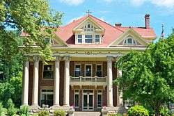
The historic Mayo Mansion was built for John C. C. Mayo between 1905 and 1912. It now serves as Our Lady of the Mountains School.[32]
The Mayo Memorial United Methodist Church was designed by one hundred Italian masons hired by John C. C. Mayo. It has several stain glass windows and has a pipe organ donated by Andrew Carnegie. The first church service was in the fall of 1909.[33]
Recreation
The Paintsville Country Club includes an 18-hole golf course established on September 27, 1929, making it one of the oldest golf courses in Eastern Kentucky.[34] The country club was built in 1930 by the WPA and is on the National Register of Historic Places.[35]
The Paintsville Recreation Center contains a volleyball court, a basketball court, a walking track, and a playground.[36]
Media
The Paintsville Herald is a bi-weekly newspaper printed on Wednesday and Friday with a circulation of about 5,200 copies. The newspaper serves Paintsville and the surrounding area.[37]
| Call Sign | Frequency | Format |
|---|---|---|
| WKLW | 94.7 FM | Hot AC |
| WSIP | 98.9 FM | Country |
| WSIP | 1490 AM | News/Talk |
| WKYH | 600 AM | News/Talk |
| WQHY | 95.5 FM | Top 40 |
Healthcare
Paul B. Hall Regional Medical Center is a full-service hospital providing healthcare to the region. The hospital has a full-service emergency room with a pediatric trauma room, a hyperbaric oxygen chamber, a special Birthing Room, and full service surgical services, including a daVinci Si robotic system providing state of the art laparoscopic surgery to the greater Paintsville region.[38]
Transportation
Roads
U.S. Route 23 serves as the bypass for Paintsville. The four-lane divided highway links Paintsville to Interstate 64 to the north and U.S. Route 119 and Kentucky Route 80 to the south. U.S. Route 460 links Paintsville to the Bert T. Combs Mountain Parkway in Salyersville. Kentucky Route 40 forms both Euclid Avenue and Third Street in Paintsville. It links the city to Inez and also serves as an alternative route to Salyersville. Kentucky Route 321, locally known as South Mayo Trail, serves as the city's main business route and passes through Mayo Plaza.
Air
Located southeast of Paintsville in neighboring Martin County is Big Sandy Regional Airport. The publicly owned, private-use airport is used for general aviation. Its main runway is 5,000 ft (1,524 m) long.[39]
The nearest airport that provides commercial aviation services is Tri-State Airport, which is located 55 miles (89 km) northeast in Ceredo, West Virginia.
Popular culture
- The majority of the 1983 film Kentucky Woman was filmed in Paintsville.[40]
- Paintsville was one of the three filming locations for the 2010 drama film, Passenger Pigeons.[41]
- ESPN's "The Season: Bluegrass Basketball" featured Paintsville and Johnson Central as one of the states most heated rivalries where a basketball game is filmed at Paintsville when the two met in regular season match-up.
Notable people
- Chris Stapleton, country, bluegrass, and rock musician signed to Universal Music Group Nashville.[42]
- Willie Blair is a former pitcher in Major League Baseball.
- Jim Ford, singer/songwriter, born in Paintsville on August 23, 1941.
- Jim Fyffe, sportscaster and radio talk-show host.
- Crystal Gayle, country music singer.
- Andrew Jackson Kirk, U.S. Representative from Kentucky.
- Johnnie LeMaster, former major league baseball player (San Francisco Giants, Cleveland Indians, Pittsburgh Pirates).
- Loretta Lynn, born at Butcher Holler, Van Lear (an unincorporated community just outside Paintsville).
- John C. C. Mayo, entrepreneur
- Wendell H. Meade, Republican member of U.S. House of Representatives.
- John Pelphrey, Kentucky "Mr. Basketball", one of four University of Kentucky basketball players dubbed "The Unforgettables"; former head men's basketball coach
- Venus Ramey, Miss America, 1944, grew up in Paintsville.[43]
- Ovie Scurlock, born in Paintsville on November 11, 1918, former jockey in horse racing.
- Benjamin F. Stapleton, Mayor of Denver, Colorado between (1923–1931) and (1935–1947).
- Richard Scott Thomas, born in Paintsville on December 3, 1925, American dancer, educator, and co-founder of the New York School of Ballet. He is the father of Richard Earl Thomas who is best known for his leading role as John-Boy Walton in the CBS drama The Waltons.[44]
See also
- Johnson County, Kentucky
- Paul B. Hall Regional Medical Center
- Citizens National Bank
- Paintsville High School
- Johnson Central High School
- U.S. 23 Country Music Highway Museum
- Francis M. Stafford House
- Johnson County Public Library
References
- 1 2 3 4 Commonwealth of Kentucky. Office of the Secretary of State. Land Office. "Paintsville, Kentucky". Accessed 24 September 2013.
- 1 2 3 4 5 Rennick, Robert. Kentucky Place Names, p. 225. University Press of Kentucky (Lexington), 1987. Accessed 25 September 2013.
- ↑ "Summary and Reference Guide to House Bill 331 City Classification Reform" (PDF). Kentucky League of Cities. Retrieved December 30, 2014.
- ↑ United States of America. Census Bureau. "2010 Census Data". Accessed 6 November 2012.
- ↑ Johnson County, Kentucky, History. "Johnson Co. History". Accessed 13 November 2009.
- ↑ Division, US Census Bureau Administration and Customer Services. "US Census Bureau Publications - Census of Population and Housing". www.census.gov. Retrieved 2016-04-09.
- ↑ "The Economics of Coal in Kentucky: Current Impacts and Future Prospects" (PDF). Mountain Association for Community Economic Development. 25 June 2009. Retrieved 8 April 2016.
- ↑ "Coal industry sheds jobs, leaving Eastern Kentucky economy in tatters". mcclatchydc. Retrieved 2016-04-09.
- ↑ Commonwealth of Kentucky. "Kentucky Department of Alcoholic Beverage Control". Accessed 11 June 2009.
- ↑ "US Gazetteer files: 2010, 2000, and 1990". United States Census Bureau. 2011-02-12. Retrieved 2011-04-23.
- ↑ Climate Summary for Paintsville, Kentucky
- 1 2 "Monthly Averages for Paintsville, KY". The Weather Channel. Retrieved May 23, 2014.
- ↑ "Annual Estimates of the Resident Population for Incorporated Places: April 1, 2010 to July 1, 2015". Retrieved July 2, 2016.
- ↑ "Census of Population and Housing". Census.gov. Retrieved June 4, 2015.
- ↑ "American FactFinder". United States Census Bureau. Retrieved 2008-01-31.
- ↑ "Kentucky: 2010: Populations and Housing Unit Counts" (PDF). US Census. September 2012. Retrieved 8 March 2016.
- 1 2 Bureau, U.S. Census. "American FactFinder - Results". factfinder.census.gov. Searching Paintsville, KY. Retrieved 2016-04-09.
- ↑ "Crime in the United States: Offenses Known to Law Enforcement". U.S. Department of Justice, Federal Bureau of Investigation. September 2010. Retrieved 2010-10-20.
- 1 2 3 Kentucky Secretary of State-Land Office Retrieved on 2009-11-21
- ↑ List of Mayors for the City of Paintsville Retrieved on 2010-08-10
- ↑ Modern Curriculum-Traditional Approach Paintsville Independent Schools. Retrieved 2013-08-01
- 1 2 Average ACT Scores by School District Kentucky Department of Education. Retrieved 2013-08-01
- ↑ Best High Schools in Kentucky U.S. News and World Report. Retrieved 2013-08-01
- ↑ Johnson County Middle School Awards Retrieved 2013-08-01
- ↑ "Johnson County schools win big at international competition". WYMT. June 18, 2013. Retrieved 2013-06-28.
- ↑ Our Lady of the Mountains School Retrieved 2013-08-01
- ↑ BSCTC-Mayo Campus Retrieved 2013-08-01
- ↑ Kentucky Apple Festival Retrieved 2013-08-18
- ↑ Awaken Conference. Retrieved 2016-04-01
- ↑ Event Information City of Paintsville. Retrieved 2013-08-18
- ↑ U.S. 23 Country Music Highway Museum Retrieved 2013-08-19.
- ↑ Our School's History Our Lady of the Mountains School. Retrieved 2013-08-19.
- ↑ National Register of Historic Places Building Profile Retrieved 2013-08-19.
- ↑ Johnson County History:1900-1950 Retrieved on 2010-2-26
- ↑ Powell, Helen National Register of Historic Places Nomination Form for Paintsville Country Club 26 January 1989. Retrieved on 2010-2-26
- ↑ Recreation Information City of Paintsville. Retrieved 2013-08-19.
- ↑ Paintsville Herald Echo Media. Retrieved 2013-08-19
- ↑ Paul B. Hall Regional Medical Center Retrieved 2012-11-06
- ↑ FAA Airport Master Record for K22 (Form 5010 PDF) Retrieved 2013-01-06
- ↑ Kentucky Woman filming locations Retrieved on 2010-1-31
- ↑ Passenger Pigeons filming locations Retrieved on 2010-1-31
- ↑ "Paintsville, Ky. native Chris Stapleton performing on CMA Awards tonight". The Herald-Dispatch. November 6, 2013. Retrieved February 10, 2014.
- ↑ Where have all the Venus Rameys gone?
- ↑ Dunning, Jennifer. "Richard S. Thomas, City Ballet Soloist and Teacher, Dies at 87," New York Times. August 4, 2013; Retrieved 2014-05-27.
External links
- City of Paintsville
- Weather Forecast for Paintsville
- K-lite 94.7
- WSIP radio
- Paintsville/Johnson County Chamber of Commerce
- Paintsville Tourism
- Paintsville Independent Schools
- Johnson County Public Schools
- The Paintsville Herald
- Kentucky Apple Festival
- Johnson County Public Library
- Paintsville Golf Course