McKee, Kentucky
| McKee, Kentucky | |
|---|---|
| City | |
|
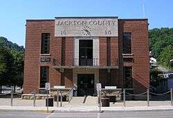
Jackson County courthouse in McKee | |
 Location of McKee, Kentucky | |
| Coordinates: 37°25′49″N 83°59′37″W / 37.43028°N 83.99361°WCoordinates: 37°25′49″N 83°59′37″W / 37.43028°N 83.99361°W | |
| Country | United States |
| State | Kentucky |
| County | Jackson |
| Incorporated | April 1, 1882 |
| Government | |
| • Type | Mayor-Council |
| • Mayor | John Tompkins |
| Area | |
| • Total | 2.3 sq mi (5.9 km2) |
| • Land | 2.3 sq mi (5.9 km2) |
| • Water | 0.0 sq mi (0.0 km2) |
| Elevation | 1,030 ft (314 m) |
| Population (2010) | |
| • Total | 800 |
| • Density | 350/sq mi (140/km2) |
| Time zone | Eastern (EST) (UTC-5) |
| • Summer (DST) | EDT (UTC-4) |
| ZIP code | 40447 |
| Area code(s) | 606 |
| FIPS code | 21-49116 |
| GNIS feature ID | 0513872 |
McKee is a 5th-class city in Jackson County, Kentucky, in the United States. It is the seat of its county.[1] The population was 800 at the 2010 census.
The city was named for Judge George R. McKee.[2]
Geography
McKee is located at 37°25′49″N 83°59′37″W / 37.43028°N 83.99361°W (37.430412, -83.993473).[3] According to the United States Census Bureau, the city has a total area of 2.3 square miles (6.0 km2), all land.
Economy
Last major employer BAE SYSTEMS has closed down. Most employment is found out of city or county for residents.
Demographics
| Historical population | |||
|---|---|---|---|
| Census | Pop. | %± | |
| 1880 | 88 | — | |
| 1900 | 106 | — | |
| 1910 | 146 | 37.7% | |
| 1920 | 173 | 18.5% | |
| 1930 | 190 | 9.8% | |
| 1960 | 234 | — | |
| 1970 | 255 | 9.0% | |
| 1980 | 759 | 197.6% | |
| 1990 | 870 | 14.6% | |
| 2000 | 878 | 0.9% | |
| 2010 | 800 | −8.9% | |
| Est. 2015 | 789 | [4] | −1.4% |
As of the census[6] of 2000, there were 878 people, 359 households, and 232 families residing in the town. The population density was 385.3 people per square mile (148.7/km²). There were 402 housing units at an average density of 176.4 per square mile (68.1/km²). The racial makeup of the city was 99.54% White, 0.11% Black or African American, and 0.34% from two or more races. Hispanic or Latino of any race were 0.11% of the population.
There were 359 households out of which 39.6% had children under the age of 18 living with them, 36.2% were married couples living together, 25.1% had a female householder with no husband present, and 35.1% were non-families. 32.0% of all households were made up of individuals and 7.8% had someone living alone who was 65 years of age or older. The average household size was 2.36 and the average family size was 2.98.
In the town the population was spread out with 31.0% under the age of 18, 15.4% from 18 to 24, 28.5% from 25 to 44, 17.1% from 45 to 64, and 8.1% who were 65 years of age or older. The median age was 27 years. For every 100 females there were 93.0 males. For every 100 females age 18 and over, there were 83.1 males.
The median income for a household in the town was $11,622, and the median income for a family was $12,857. Males had a median income of $20,000 versus $13,750 for females. The per capita income for the town was $7,589. About 48.3% of families and 53.3% of the population were below the poverty line, including 65.8% of those under age 18 and 29.8% of those age 65 or over.
References
- ↑ "Find a County". National Association of Counties. Archived from the original on May 31, 2011. Retrieved 2011-06-07.
- ↑ Collins, Lewis (1877). History of Kentucky. p. 352.
- ↑ "US Gazetteer files: 2010, 2000, and 1990". United States Census Bureau. 2011-02-12. Retrieved 2011-04-23.
- ↑ "Annual Estimates of the Resident Population for Incorporated Places: April 1, 2010 to July 1, 2015". Retrieved July 2, 2016.
- ↑ "Census of Population and Housing". Census.gov. Archived from the original on May 11, 2015. Retrieved June 4, 2015.
- ↑ "American FactFinder". United States Census Bureau. Archived from the original on September 11, 2013. Retrieved 2008-01-31.
Municipalities and communities of Jackson County, Kentucky, United States | ||
|---|---|---|
| City | 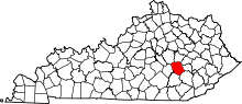 | |
| CDP | ||
| Unincorporated communities | ||
