Avenue D (Manhattan)
|
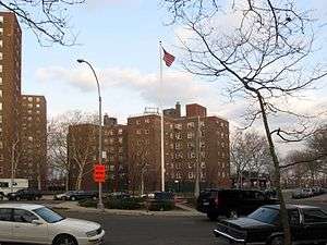
The Jacob Riis Houses, located on Avenue D | |
| Other name(s) |
Abraham Kazan Street Columbia Street |
|---|---|
| Owner | City of New York |
| Maintained by | NYCDOT |
| Length | 0.9 mi[1] (1.4 km) |
| Location | Manhattan, New York City |
| Postal code | 10002, 10009 |
| South end | Grand Street in Lower East Side |
| North end | 12th Street in Alphabet City |
| East | Franklin D. Roosevelt Drive |
| West | Avenue C |
| Construction | |
| Commissioned | March 1811 |
Avenue D is the easternmost named avenue in the East Village neighborhood of Manhattan, New York City, east of Avenue C and west of the FDR Drive. It runs between East 12th and Houston Streets, and continues south of Houston Street as Columbia Street until Delancey Street and Abraham Kazan Street until its end at Grand Street. Avenues A, B, C and D are the genesis of the name for Alphabet City section of the East Village neighborhood, which they run through.
History
The street was created by the Commissioners' Plan of 1811 as one of 16 north-south streets specified as 100 feet (30 m) in width, including 12 numbered avenues and four designated by letter located east of First Avenue.[2]
Transportation
Avenue D is served by the M14D bus from East 10th Street to Houston Street (southbound) and Delancey Street (northbound) via Columbia Street.
Structures
Among the structures along this avenue are:
- Dry Dock Park, located at the northern end (11th and Avenue D), a small park with a public pool—named for the neighborhood's former tradition of ship repair. The corner was formerly the site of the Corn Exchange Bank Trust Co.
- Many of the larger Public Housing projects in Alphabet City are on Avenue D. The east side of Avenue D is flanked by the Jacob Riis Houses (NYCHA housing), named for famous photographer Jacob Riis, who chronicled the plight of the city's poorest residents. The development was designed by Walker & Gillette and was completed in 1949.[3] Other projects include Baruch Houses, LaGuardia Houses, and the Lillian Wald Houses, named for Lillian D. Wald (1867-1940), who provided aid to the Lower East Side through the Henry Street Settlement and the Visiting Nurses Society.
- Between 5th and 6th streets, east of Avenue D, was formerly the location of the "Boys Brotherhood Republic", a self-governing youth project of the Henry Street Settlement.[4]
Among many notables who were born or raised on Manhattan's Lower East Side, it is purported that James Cagney was born on Avenue D.
References
- ↑ Google (September 1, 2015). "Avenue D (Manhattan)" (Map). Google Maps. Google. Retrieved September 1, 2015.
- ↑ Morris, Gouverneur; De Witt, Simeon; and Rutherford, John [sic] (March 1811) "Remarks Of The Commissioners For Laying Out Streets And Roads In The City Of New York, Under The Act Of April 3, 1807", Cornell University Library. Accessed June 27, 2016. "These are one hundred feet wide, and such of them as can be extended as far north as the village of Harlem are numbered (beginning with the most eastern, which passes from the west of Bellevue Hospital to the east of Harlem Church) 1, 2, 3, 4, 5, 6, 7, 8, 9, 10, 11, and 12. This last runs from the wharf at Manhattanville nearly along the shore of the Hudson river, in which it is finally lost, as appears by the map. The avenues to the eastward of number one are marked A, B, C, and D."
- ↑ Jacob Riis Houses | Buildings | EMPORIS
- ↑ "Boys and Girls Republic" on the Henry Street Settlement website
External links
| Wikimedia Commons has media related to Avenue D (Manhattan). |
- New York Songlines: Avenue D, a virtual walking tour