First Avenue (Manhattan)
|
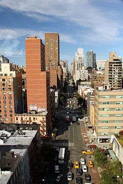
First Avenue at Lenox Hill in the Upper East Side, looking north from the Roosevelt Island Tramway | |
| Owner | City of New York |
|---|---|
| Maintained by | NYCDOT |
| Length | 6.3 mi[1] (10.1 km) |
| Location | Manhattan, New York City |
| South end | Houston / Allen Streets in Lower East Side |
| Major junctions |
|
| North end | East 126th Street in East Harlem |
| East |
Avenue A (between Houston St and 14th St) FDR Dr (between 14th and 53rd St) Sutton Place (between 53rd and 59th St) York Avenue (59th St to 90th St) Pleasant Avenue (between 114th to 120th St) |
| West | Second Avenue |
| Construction | |
| Commissioned | March 1811 |
First Avenue is a north-south thoroughfare on the East Side of the New York City borough of Manhattan, running from Houston Street northbound for over 125 blocks before terminating at the Willis Avenue Bridge into The Bronx at the Harlem River near East 126th Street. South of Houston Street, the roadway continues as Allen Street south to Division Street. Traffic on First Avenue runs northbound (uptown) only.
History
Like most of Manhattan's major north-south Avenues, First Avenue was proposed as part of the Commissioners' Plan of 1811 for Manhattan, which designated 12 broad north-south Avenues running the length of the island. The southern portions of the Avenue were cut and laid out shortly after the plan was adopted. The northern sections of the Avenue would be graded and cut through at various intervals throughout the 19th Century as the northward development of the island demanded.
The IRT Second Avenue Line ran above First Avenue from Houston Street to 23rd Street before turning left at 23rd and then right onto Second Avenue. This elevated line was torn down in 1942.
First Avenue has carried one-way traffic since June 4, 1951.[2]
A protected bike lane was established along the left side of the avenue south of 50th Street in 2011.
Description
First Avenue passes through a variety of mostly residential neighborhoods. Between 42nd Street and 45th Street, it borders the United Nations headquarters complex, and four lanes are underground.
Starting in the south at Houston Street, First Avenue passes through the East Village, once a predominantly German and Jewish neighborhood, now a trendy area populated mostly by hipsters and young professionals. First Avenue then runs by two large urban development projects, Stuyvesant Town and Peter Cooper Village, two middle income housing developments that sit on what used to be the Gashouse District, an industrial area. These fill the east side of the avenue from 14th to 23rd Streets. The avenue is very wide in this segment, and is separated by a median. The New York Veterans Affairs Medical Center, the Bellevue Hospital Center, and NYU Medical Center fill the blocks from there to 34th Street. Between 42nd and 47th streets, the avenue runs past United Nations Headquarters. Here a local bypass, United Nations Plaza, splits from the main road, which runs through the First Avenue Tunnel, rejoining the local street at 49th Street.
Crossing under the Queensboro Bridge and entering the Upper East Side, First Avenue runs through a number of residential areas of varying character and income. It serves as one of the main shopping streets of the Yorkville neighborhood, historically a German and Hungarian neighborhood, today a mix of upper middle class residents. In this area First Avenue is also known as "Bedpan Alley" (a play on "Tin Pan Alley") because of the large number of hospitals located nearby.
Crossing 96th Street, First Avenue runs through Spanish Harlem, a historically Puerto Rican neighborhood. Before Puerto Rican migration in the 1950s, much of this area was populated by Italians and known as "Italian Harlem". First Avenue in Italian Harlem was the site of a major open-air pushcart market in the late 19th and early 20th Centuries. There is still a small Italian enclave in the Pleasant Valley section of East Harlem, between 114th and 120th Streets. The northern reaches of First Avenue, north of roughly 110th Street have also seen a significant increase in Mexican residents.
First Avenue then connects to the Willis Avenue Bridge, which crosses the Harlem River at 125th Street and connects to Willis Avenue in the Bronx.
In popular culture
- The opening scene of Ghostbusters II was filmed at the intersection of First Avenue and 77th Street.
- In the Seinfeld TV series, Kramer describes the intersection of First Avenue and 1st Street as the "nexus of the universe". This provided the name for a nightclub called the Nexus Lounge at that location.
Gallery
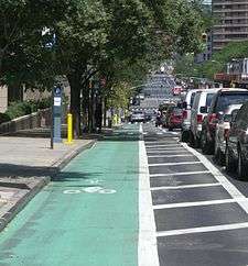 Bike lane on First Avenue
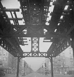 Looking south on First Avenue from 13th Street during the demolition of the Second Avenue El in September 1942
 United Nations headquarters at First Avenue and 42nd Street
References
Notes
- ↑ Google (September 1, 2015). "First Avenue (Manhattan)" (Map). Google Maps. Google. Retrieved September 1, 2015.
- ↑ Ingraham, Joseph (June 5, 1951). "Autos Speeded 15% on 1st And 2nd Aves". The New York Times. Retrieved August 28, 2012.
External links
| Wikimedia Commons has media related to 1st Avenue (Manhattan). |
- New York Songlines: First Avenue, a virtual walking tour