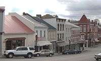
Flemingsburg, Kentucky
| Flemingsburg, Kentucky | |
|---|---|
| City | |
 | |
| Motto: "The friendly town that hospitality built" | |
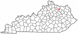 Location of Flemingsburg, Kentucky | |
| Coordinates: 38°25′14″N 83°44′15″W / 38.42056°N 83.73750°WCoordinates: 38°25′14″N 83°44′15″W / 38.42056°N 83.73750°W | |
| Country | United States |
| State | Kentucky |
| County | Fleming |
| Area | |
| • Total | 2.04 sq mi (5.29 km2) |
| • Land | 2.03 sq mi (5.27 km2) |
| • Water | 0.008 sq mi (0.02 km2) |
| Elevation | 814 ft (248 m) |
| Population (2010) | |
| • Total | 2,658 |
| • Density | 1,307/sq mi (504.5/km2) |
| Time zone | Eastern (EST) (UTC-5) |
| • Summer (DST) | EDT (UTC-4) |
| ZIP code | 41041 |
| Area code(s) | 606 |
| FIPS code | 21-27856 |
| GNIS feature ID | 0492237 |
| Website |
www |
Flemingsburg is a home rule-class city[1] in Fleming County, Kentucky, in the United States. The population was 2,658 at the 2010 census,[2] down from 3,010 at the 2000 census. It is the seat of Fleming County.[3]
Geography
Flemingsburg is located northwest of the center of Fleming County at 38°25′14″N 83°44′15″W / 38.42056°N 83.73750°W (38.420541, -83.737581).[4] It is in northeastern Kentucky, 17 miles (27 km) south of Maysville, 31 miles (50 km) northeast of Mt. Sterling, and 38 miles (61 km) northeast of Paris.
According to the United States Census Bureau, Flemingsburg has a total area of 2.0 square miles (5.3 km2), of which 0.01 square miles (0.02 km2), or 0.33%, is water.[2]
History
Flemingsburg was founded in 1797 by George S. Stockton, a native Virginian, who named the town and county after his half-brother Colonel John Fleming.[5] It has been the seat of Fleming County since its formation and was formally incorporated by the state assembly in 1812.[6][7]
Demographics
| Historical population | |||
|---|---|---|---|
| Census | Pop. | %± | |
| 1800 | 123 | — | |
| 1830 | 648 | — | |
| 1840 | 591 | −8.8% | |
| 1850 | 759 | 28.4% | |
| 1870 | 425 | — | |
| 1880 | 811 | 90.8% | |
| 1890 | 1,172 | 44.5% | |
| 1900 | 1,268 | 8.2% | |
| 1910 | 1,219 | −3.9% | |
| 1920 | 1,562 | 28.1% | |
| 1930 | 1,265 | −19.0% | |
| 1940 | 1,542 | 21.9% | |
| 1950 | 1,502 | −2.6% | |
| 1960 | 2,067 | 37.6% | |
| 1970 | 2,483 | 20.1% | |
| 1980 | 2,835 | 14.2% | |
| 1990 | 3,071 | 8.3% | |
| 2000 | 3,010 | −2.0% | |
| 2010 | 2,658 | −11.7% | |
| Est. 2015 | 2,894 | [8] | 8.9% |
As of the census[10] of 2000, there were 3,010 people, 1,294 households, and 821 families residing in the city. The population density was 1,178.2 people per square mile (455.8/km²). There were 1,434 housing units at an average density of 561.3 per square mile (217.1/km²). The racial makeup of the city was 92.72% White, 5.05% African American, 0.10% Native American, 0.40% Asian, 0.43% from other races, and 1.30% from two or more races. Hispanic or Latino of any race were 1.03% of the population.
There were 1,294 households out of which 29.3% had children under the age of 18 living with them, 45.5% were married couples living together, 14.8% had a female householder with no husband present, and 36.5% were non-families. 33.9% of all households were made up of individuals and 18.2% had someone living alone who was 65 years of age or older. The average household size was 2.25 and the average family size was 2.87.
In the city the population was spread out with 23.3% under the age of 18, 7.9% from 18 to 24, 25.2% from 25 to 44, 23.2% from 45 to 64, and 20.5% who were 65 years of age or older. The median age was 41 years. For every 100 females there were 81.3 males. For every 100 females age 18 and over, there were 74.1 males.
The median income for a household in the city was $23,708, and the median income for a family was $33,365. Males had a median income of $26,550 versus $21,165 for females. The per capita income for the city was $14,914. About 15.0% of families and 19.0% of the population were below the poverty line, including 23.5% of those under age 18 and 26.8% of those age 65 or over.
Noted inhabitants
- James J. Andrews, Civil War spy
- Landaff Andrews, United States Representative
- Herman Chittison, jazz musician
- Leander Cox, congressman
- Joseph J. Reynolds, Union Army general
- Alvin Saunders, United States senator from Nebraska
- Franklin R. Sousley, one of six men who raised the second American flag on Mount Suribachi during the Battle of Iwo Jima
- Nelson Stacy, NASCAR and ARCA driver
- Lawrence S. Trimble, congressman
Climate
The climate in this area is characterized by hot, humid summers and generally mild to cool winters. According to the Köppen Climate Classification system, Flemingsburg has a humid subtropical climate, abbreviated "Cfa" on climate maps.[11]
References
- ↑ "Summary and Reference Guide to House Bill 331 City Classification Reform" (PDF). Kentucky League of Cities. Retrieved December 30, 2014.
- 1 2 "Geographic Identifiers: 2010 Census Summary File 1 (G001), Flemingsburg city, Kentucky". American FactFinder. U.S. Census Bureau. Retrieved May 20, 2016.
- ↑ "Find a County". National Association of Counties. Retrieved 2011-06-07.
- ↑ "US Gazetteer files: 2010, 2000, and 1990". United States Census Bureau. 2011-02-12. Retrieved 2011-04-23.
- ↑ Rennick, Robert M. (1987). Kentucky Place Names. University Press of Kentucky. p. 103. Retrieved 28 Apr 2013.
- ↑ Commonwealth of Kentucky. Office of the Secretary of State. Land Office. "Flemingsburg, Kentucky". Accessed 26 Jul 2013.
- ↑ Collins, Lewis (1877). History of Kentucky. p. 230.
- ↑ "Annual Estimates of the Resident Population for Incorporated Places: April 1, 2010 to July 1, 2015". Retrieved July 2, 2016.
- ↑ "Census of Population and Housing". Census.gov. Retrieved June 4, 2015.
- ↑ "American FactFinder". United States Census Bureau. Retrieved 2008-01-31.
- ↑ Climate Summary for Flemingsburg, Kentucky
External links
Municipalities and communities of Fleming County, Kentucky, United States | ||
|---|---|---|
| Cities | 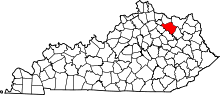 | |
| CDP | ||
| Other unincorporated communities | ||