Burlington, Kentucky
| Burlington, Kentucky | |
|---|---|
| Census-designated place | |
|
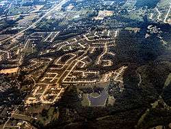
Burlington from the air, looking east | |
 Location within Boone County and the state of Kentucky | |
| Coordinates: 39°1′26″N 84°43′2″W / 39.02389°N 84.71722°WCoordinates: 39°1′26″N 84°43′2″W / 39.02389°N 84.71722°W | |
| Country | United States |
| State | Kentucky |
| County | Boone |
| Area | |
| • Total | 8.8 sq mi (22.9 km2) |
| • Land | 8.8 sq mi (22.9 km2) |
| • Water | 0.0 sq mi (0.0 km2) |
| Elevation | 840 ft (256 m) |
| Population (2010) | |
| • Total | 15,926 |
| • Density | 1,802/sq mi (695.6/km2) |
| Time zone | Eastern (EST) (UTC-5) |
| • Summer (DST) | EDT (UTC-4) |
| ZIP code | 41005 |
| Area code(s) | 859 |
| FIPS code | 21-11170 |
| GNIS feature ID | 0488440 |
Burlington is a census-designated place (CDP) in and the county seat of Boone County, Kentucky, United States.[1] The population was 15,926 at the 2010 census.[2]
History
Burlington was incorporated in 1824.[3]
Geography
Burlington is located in north-central Boone County. Kentucky Route 18 (Burlington Pike) runs through the center of the CDP, leading east 6 miles (10 km) to Florence and west 7 miles (11 km) to the Ohio River at Belleview. Downtown Cincinnati is 16 miles (26 km) to the northeast, and Cincinnati/Northern Kentucky International Airport is directly to the northeast of Burlington.
According to the United States Census Bureau, Burlington has a total area of 8.8 square miles (22.9 km2), all land.[2]
Demographics
As of the census[4] of 2000, there were 10,779 people, 3,799 households, and 2,887 families residing in the CDP. The population density was 1,276.0 people per square mile (492.5/km²). There were 4,083 housing units at an average density of 483.4 per square mile (186.6/km²). The racial makeup of Burlington in 2006 was 93.9% White, 1.89% African American, 0.6% Native American, 1.11% Asian, 0.01% Pacific Islander, 0.94% from other races, and 1.06% from two or more races. Hispanic or Latino of any race were 1.73% of the population.
There were 3,799 households out of which 42.9% had children under the age of 18 living with them, 62.3% were married couples living together, 10.2% had a female householder with no husband present, and 24.0% were non-families. 19.0% of all households were made up of individuals and 3.9% had someone living alone who was 65 years of age or older. The average household size was 2.77 and the average family size was 3.19.
In the CDP the population was spread out with 30.1% under the age of 18, 9.8% from 18 to 24, 36.3% from 25 to 44, 18.2% from 45 to 64, and 5.7% who were 65 years of age or older. The median age was 31 years. For every 100 females there were 104.1 males. For every 100 females age 18 and over, there were 101.3 males.
The median income for a household in the CDP was $56,815, and the median income for a family was $63,387. Males had a median income of $41,083 versus $28,288 for females. The per capita income for the CDP was $22,806. About 2.3% of families and 2.6% of the population were below the poverty line, including 3.0% of those under age 18 and 1.4% of those age 65 or over.
Climate
The climate in this area is characterized by hot, humid summers and generally mild to cool winters. According to the Köppen Climate Classification system, Burlington has a humid subtropical climate, abbreviated "Cfa" on climate maps.[5]
References
- ↑ "Find a County". National Association of Counties. Archived from the original on 2011-05-31. Retrieved 2011-06-07.
- 1 2 "Geographic Identifiers: 2010 Demographic Profile Data (G001): Burlington CDP, Kentucky". U.S. Census Bureau, American Factfinder. Retrieved November 20, 2013.
- ↑ Federal Writers' Project (1996). The WPA Guide to Kentucky. University Press of Kentucky. p. 263. Retrieved 24 November 2013.
- ↑ "American FactFinder". United States Census Bureau. Archived from the original on 2013-09-11. Retrieved 2008-01-31.
- ↑ Climate Summary for Burlington, Kentucky
External links
-
 Media related to Burlington, Kentucky at Wikimedia Commons
 - Historical Images and Texts of Boone County, Kentucky
Municipalities and communities of Boone County, Kentucky, United States | ||
|---|---|---|
| Cities | 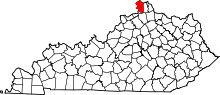 | |
| CDPs | ||
| Unincorporated Communities | ||
| Ghost town | ||
| Footnotes | ‡This populated place also has portions in an adjacent county or counties. | |