Richlands, Virginia
| Town of Richlands, Virginia | ||
|---|---|---|
| Town | ||
|
Miners at the Virginia-Pocahontas Coal Company Mine #4 near Richlands, 1974 | ||
| ||
| Motto: The Center of a Friendly Circle | ||
 Location in the Commonwealth of Virginia | ||
| Coordinates: 37°5′40″N 81°48′22″W / 37.09444°N 81.80611°WCoordinates: 37°5′40″N 81°48′22″W / 37.09444°N 81.80611°W | ||
| Country | United States | |
| State | Virginia | |
| County | Tazewell | |
| Incorporated | 1892 | |
| Government | ||
| • Mayor | Jan White | |
| Area | ||
| • Total | 2.7 sq mi (6.9 km2) | |
| • Land | 2.7 sq mi (6.9 km2) | |
| • Water | 0.0 sq mi (0.0 km2) | |
| Elevation | 1,932 ft (589 m) | |
| Population (2000) | ||
| • Total | 4,144 | |
| • Density | 1,566/sq mi (604.5/km2) | |
| U.S. Census Bureau, 2000 Population Estimates | ||
| Time zone | EST (UTC-5) | |
| • Summer (DST) | EDT (UTC-4) | |
| ZIP code | 24641 | |
| Area code(s) | 276 | |
| FIPS code | 51-66928[1] | |
| GNIS feature ID | 1473194[2] | |
| Website | http://town.richlands.va.us/ | |

Richlands is a town in Tazewell County, Virginia, United States. The population was 5,823 at the 2010 census. It is part of the Bluefield, WV-VA micropolitan area which has a population of 107,578.
History
Located along the banks of the Clinch River, Richlands began as a farming community and was named for its fertile "rich lands."
The Clinch Valley Coal & Iron Company began to develop Richlands in 1890, and company officials hoped Richlands' readily available coal, iron, and timber might make it the "Pittsburgh of the South." The company abandoned its plans following a stock market crash in 1893.[3]
Richlands was incorporated in 1892.
In February 1893, Richlands was the site of a mass lynching of five black railroad workers after it was alleged some of the men had robbed and beat a white man. Four of the railroad workers were arrested and held in the Richlands jail, but the jailor was overpowered by a mob of white townspeople, including James Hurt, a magistrate and member of Richlands' town council, and James Crabtree, a prominent businessman, who removed the four men and hanged them from the same tree. A fifth black railroad worker was later found and lynched.[4]
The Richlands Historic District encompasses much of downtown Richlands, and the Tazewell Avenue Historic District, and Williams House, are both listed on the National Register of Historic Places.[5]
Geography
According to the United States Census Bureau, the town has a total area of 2.7 square miles (6.9 km²), all land.
Demographics
| Historical population | |||
|---|---|---|---|
| Census | Pop. | %± | |
| 1900 | 475 | — | |
| 1910 | 743 | 56.4% | |
| 1920 | 1,171 | 57.6% | |
| 1930 | 1,355 | 15.7% | |
| 1940 | 2,203 | 62.6% | |
| 1950 | 4,648 | 111.0% | |
| 1960 | 4,963 | 6.8% | |
| 1970 | 4,843 | −2.4% | |
| 1980 | 5,796 | 19.7% | |
| 1990 | 4,456 | −23.1% | |
| 2000 | 4,144 | −7.0% | |
| 2010 | 5,823 | 40.5% | |
| Est. 2015 | 5,504 | [6] | −5.5% |
As of the census[1] of 2010, there were 5,823 people, 2,552 households, and 1,632 families residing in the town. The population density was 1,565.7 people per square mile (603.8/km²). There were 2,137 housing units at an average density of 807.4 per square mile (311.4/km²). The racial makeup of the town was 98.75% White, 0.05% African American, 0.12% Native American, 0.51% Asian, 0.19% from other races, and 0.39% from two or more races. Hispanic or Latino of any race were 0.34% of the population.
There were 1,882 households out of which 25.2% had children under the age of 18 living with them, 48.7% were married couples living together, 12.8% had a female householder with no husband present, and 35.0% were non-families. 32.1% of all households were made up of individuals and 15.6% had someone living alone who was 65 years of age or older. The average household size was 2.20 and the average family size was 2.76.
In the town the population was spread out with 20.1% under the age of 18, 8.3% from 18 to 24, 27.7% from 25 to 44, 25.4% from 45 to 64, and 18.5% who were 65 years of age or older. The median age was 41 years. For every 100 females there were 81.9 males. For every 100 females age 18 and over, there were 79.0 males.
The median income for a household in the town was $23,712, and the median income for a family was $30,257. Males had a median income of $30,682 versus $18,670 for females. The per capita income for the town was $15,548. About 13.6% of families and 17.8% of the population were below the poverty line, including 24.1% of those under age 18 and 16.9% of those age 65 or over.
Education
Richlands is served by the Tazewell County Public School System. Schools in Richlands include:
- Richlands Elementary School
- Richlands Middle School
- Richlands High School
It is served by Southwest Virginia Community College, which is located in nearby Wardell, Virginia. King University, based in Bristol, Tennessee, has a satellite campus at SWVCC.
In popular culture
Blues musician Mississippi John Hurt performed Richland Women Blues. The lyrics were risqué for the early 1930s, filled with sexual double entendres.[8][9]
Notable people
- Mike Compton, former guard for the Detroit Lions, New England Patriots and Jacksonville Jaguars.[10]
- Cathryn Hankla, poet and artist.
- Jim Moody, member of U.S. House of Representatives from Wisconsin.
- Heath Miller, professional football player (Tight End) for the Pittsburgh Steelers.
- Debi Thomas, figure skater, 1988 Olympic Bronze medalist[11]
References
- 1 2 "American FactFinder". United States Census Bureau. Archived from the original on September 11, 2013. Retrieved 2008-01-31.
- ↑ "US Board on Geographic Names". United States Geological Survey. 2007-10-25. Retrieved 2008-01-31.
- ↑ Tennis, Joe (2004). Southwest Virginia Crossroads: An Almanac of Place Names And Places to See. Joe Tennis.
- ↑ Brundage, William Fitzhugh (1993). Lynching in the New South: Georgia and Virginia, 1880 - 1930. University of Illinois.
- ↑ National Park Service (2010-07-09). "National Register Information System". National Register of Historic Places. National Park Service.
- ↑ "Annual Estimates of the Resident Population for Incorporated Places: April 1, 2010 to July 1, 2015". Retrieved July 2, 2016.
- ↑ "Census of Population and Housing". Census.gov. Archived from the original on May 11, 2015. Retrieved June 4, 2015.
- ↑ Ratcliffe, Philip R. (2011). Mississippi John Hurt: His Life, His Times, His Blues. University Press of Mississippi.
- ↑ "Richland Women Blues". Mississippi John Hurt Museum.
- ↑ "Michael Eugene Compton". databaseBasketball.com. Retrieved November 10, 2012.
- ↑ "Once famous, Debi Thomas is now bankrupt and living in a trailer". The Virginian-Pilot. Retrieved March 23, 2016.
External links
| Wikimedia Commons has media related to Richlands, Virginia. |
Municipalities and communities of Tazewell County, Virginia, United States | ||
|---|---|---|
| Towns | 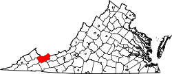 | |
| CDPs | ||
| Unincorporated communities | ||
| Footnotes | ‡This populated place also has portions in an adjacent county or counties | |