Big Stone Gap, Virginia
| Town of Big Stone Gap, Virginia | ||
|---|---|---|
| Town | ||
|
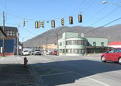
Central Big Stone Gap. Little Stone Mountain is visible in the background. | ||
| ||
 Location in the Commonwealth of Virginia | ||
| Coordinates: 36°52′54″N 82°44′50″W / 36.88167°N 82.74722°WCoordinates: 36°52′54″N 82°44′50″W / 36.88167°N 82.74722°W | ||
| Country | United States | |
| State | Virginia | |
| County | Wise | |
| Government | ||
| • Mayor | Leonard Rogers | |
| Area | ||
| • Total | 4.9 sq mi (12.6 km2) | |
| • Land | 4.9 sq mi (12.6 km2) | |
| • Water | 0.0 sq mi (0.0 km2) | |
| Elevation | 1,535 ft (468 m) | |
| Population (2010) | ||
| • Total | 5,643 | |
| • Density | 996/sq mi (384.5/km2) | |
| U.S. Census Bureau, 2010 Population Estimates | ||
| Time zone | EST (UTC-5) | |
| • Summer (DST) | EDT (UTC-4) | |
| ZIP code | 24219 | |
| Area code(s) | 276 | |
| FIPS code | 51-07480[1] | |
| GNIS feature ID | 1496805[2] | |
| Website | Official website | |

Big Stone Gap is a town in Wise County, Virginia, United States. The population was 5,643 at the 2010 census.
History
The community was formerly known as "Mineral City" and "Three Forks." The "Big Stone Gap" refers to the valley which has been created on the Appalachia Straight, located between Big Stone Gap and Appalachia. The town had hoped that its coal and iron ore deposits would make it "the Pittsburgh of the South."[3]
The Big Stone Gap post office was established in 1856.[4]
The Christ Episcopal Church, John Fox, Jr. House, Southwest Virginia Museum Historical State Park, Terrace Park Girl Scout Cabin, June Tolliver House, and C. Bascom Slemp Federal Building are listed on the National Register of Historic Places.[5]
Museums
Big Stone Gap is home to several museums. The June Tolliver House, located on Jerome Street, is home to the Trail of the Lonesome Pine, the official outdoor drama of Virginia.

The Southwest Virginia Museum Historical State Park is located in the downtown area. Big Stone Gap also hosts the Coal Museum.
Federal court
The federal building named for C. Bascom Slemp was built in 1912 and it continues to house a division of the United States District Court for the Western District of Virginia.
Wallens Ridge State Prison
Big Stone Gap is home to Wallens Ridge State Prison, a state prison that has been a part of the Commonwealth of Virginia Department of Corrections since 1999. Originally opened as a supermax prison, it has recently been downgraded to a "high level" security facility. Construction and maintenance of the facility generated millions of dollars for the local economy, suppressed from a sagging history of coal mining.[6]
Notable people
- Rufus A. Ayers - Former Virginia Attorney General
- Leanza Cornett - Miss America 1993
- Raymond Allen Davis - Central Intelligence Agency Operative
- John Fox, Jr. - Author
- Abner Linwood Holton Jr. - Former Virginia governor[7]
- Julius Jones - Professional Football Player
- Thomas Jones - Professional Football Player
- Joseph L. Kelly - Virginia Supreme Court Justice
- Carl Martin - Musician[8]
- Adriana Trigiani - Author
- Roy Cornelius Smith - Opera Singer
- CC Swiney - Film Actor
Geography
Big Stone Gap is located at 36°52′02″N 82°46′28″W / 36.867165°N 82.774471°W (36.867165, -82.774471).[9]
According to the United States Census Bureau, the town has a total area of 4.9 square miles (12.6 km2), all land.
Big Stone Gap is at the junction of U.S. Route 23 and U.S. Route 58 Alternate.
Big Stone Gap is closer to the state capitals of seven other states than it is to Richmond, VA, its own state capital, with regards to highway mileage. The other state capitals are Columbus, OH; Frankfort, KY; Charleston, WV; Nashville, TN; Raleigh, NC; Columbia, SC; and Atlanta GA. Additionally Indianapolis, Indiana is only six miles farther from Big Stone Gap than Richmond.
Demographics
| Historical population | |||
|---|---|---|---|
| Census | Pop. | %± | |
| 1900 | 1,617 | — | |
| 1910 | 2,590 | 60.2% | |
| 1920 | 3,009 | 16.2% | |
| 1930 | 3,908 | 29.9% | |
| 1940 | 4,331 | 10.8% | |
| 1950 | 5,173 | 19.4% | |
| 1960 | 4,688 | −9.4% | |
| 1970 | 4,153 | −11.4% | |
| 1980 | 4,748 | 14.3% | |
| 1990 | 4,748 | 0.0% | |
| 2000 | 4,856 | 2.3% | |
| 2010 | 5,643 | 16.2% | |
| Est. 2015 | 5,416 | [10] | −4.0% |
| source:[11] | |||
As of the census[1] of 2010, there were 5,643 people, 2,034 households, and 1,075 families residing in the town. The population density was 995.9 people per square mile (384.2/km2). There were 2,197 housing units at an average density of 450.6 per square mile (173.8/km2). The racial makeup of the town was 93.68% White, 4.41% African American, 0.14% Native American, 0.45% Asian, 0.02% Pacific Islander, 0.37% from other races, and 0.93% from two or more races. Hispanic or Latino of any race were 0.60% of the population.
There were 1,995 households out of which 29.6% had children under the age of 18 living with them, 48.7% were married couples living together, 15.3% had a female householder with no husband present, and 33.2% were non-families. 30.8% of all households were made up of individuals and 13.8% had someone living alone who was 65 years of age or older. The average household size was 2.34 and the average family size was 2.92.
In the town the population was spread out with 23.2% under the age of 18, 9.0% from 18 to 24, 24.9% from 25 to 44, 25.1% from 45 to 64, and 17.9% who were 65 years of age or older. The median age was 40 years. For every 100 females there were 86.9 males. For every 100 females age 18 and over, there were 80.5 males.
The median income for a household in the town was $21,584, and the median income for a family was $34,306. Males had a median income of $26,707 versus $21,915 for females. The per capita income for the town was $13,284. About 22.4% of families and 25.8% of the population were below the poverty line, including 34.5% of those under age 18 and 15.1% of those age 65 or over.
Education
Big Stone Gap is home to three public schools: Powell Valley Primary School, Powell Valley Middle School, and Union High School, formerly Powell Valley High School.[12] Powell Valley High School was consolidated with Appalachia High School in the Fall of 2011.[13]
Big Stone Gap is also home to Mountain Empire Community College.
King University, based in Bristol, Tennessee, has a satellite campus in Big Stone Gap at the Mountain Empire Community College location.
Film
Adriana Trigiani, who wrote the script for the movie Big Stone Gap, lobbied to have the film shot on location. The former gas station that was the setting for Carmine's restaurant in the movie still contains the soda fountain, tables and nostalgic wall posters used during filming. Next to it is the vacant Mutual's Pharmacy, where Ave Marie Mulligan, the main character in the movie, worked.[3]
2008 Tornado
An EF-1 tornado touched down March 4, 2008, on Highway 58, running through downtown. The tornado caused a 300 yard wide, one mile long path of damage. It destroyed six homes, caused major damage to 15 homes, and minor damage to 25 others. The tornado hit an area of the town named Poplar Hill.
References
- 1 2 "American FactFinder". United States Census Bureau. Archived from the original on 2013-09-11. Retrieved 2008-01-31.
- ↑ "US Board on Geographic Names". United States Geological Survey. 2007-10-25. Retrieved 2008-01-31.
- 1 2 Hensley, Clayton (27 July 2014). "Big Stone Gap awaits its time on the big screen". The Knoxville News-Sentinel. Retrieved 28 July 2014.
- ↑ "Wise County". Jim Forte Postal History. Archived from the original on 6 October 2014. Retrieved 30 September 2014.
- ↑ National Park Service (2010-07-09). "National Register Information System". National Register of Historic Places. National Park Service.
- ↑ Washingtonpost.com – At Va.'s Toughest Prison, Tight Controls
- ↑ SWVAmuseum.org – Southwest Virginia Museum Historical State Park
- ↑ "Biography by Al Campbell". Allmusic.com. Retrieved September 3, 2011.
- ↑ "US Gazetteer files: 2010, 2000, and 1990". United States Census Bureau. 2011-02-12. Retrieved 2011-04-23.
- ↑ "Annual Estimates of the Resident Population for Incorporated Places: April 1, 2010 to July 1, 2015". Retrieved July 2, 2016.
- ↑ "Population Finder: Big Stone Gap CDP, Virginia". U.S. Census Bureau. Retrieved 2011-11-07.
- ↑ "Wise County Public Schools > Home". Wise.k12.va.us. Retrieved 2016-11-08.
- ↑ "No disharmony in Wise County school consolidation". Tricities.com. 2011-08-30. Retrieved 2016-11-08.
Municipalities and communities of Wise County, Virginia, United States | ||
|---|---|---|
| Towns | 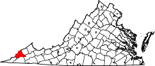 | |
| CDP | ||
| Unincorporated communities | ||
| Footnotes | ‡This populated place also has portions in an adjacent county or counties | |