Avignonet
| Avignonet | |
|---|---|
|
Monteynard Lake on the border with Monteynard | |
 Avignonet | |
|
Location within Auvergne-Rhône-Alpes region  Avignonet | |
| Coordinates: 44°57′35″N 5°39′28″E / 44.9597°N 5.6578°ECoordinates: 44°57′35″N 5°39′28″E / 44.9597°N 5.6578°E | |
| Country | France |
| Region | Auvergne-Rhône-Alpes |
| Department | Isère |
| Arrondissement | Grenoble |
| Canton | Monestier-de-Clermont |
| Intercommunality | Canton de Monestier de Clermont |
| Government | |
| • Mayor (2007–2020) | Jérôme Fauconnier |
| Area1 | 8 km2 (3 sq mi) |
| Population (2010)2 | 214 |
| • Density | 27/km2 (69/sq mi) |
| Time zone | CET (UTC+1) |
| • Summer (DST) | CEST (UTC+2) |
| INSEE/Postal code | 38023 / 38650 |
| Elevation | 362–825 m (1,188–2,707 ft) |
|
1 French Land Register data, which excludes lakes, ponds, glaciers > 1 km² (0.386 sq mi or 247 acres) and river estuaries. 2 Population without double counting: residents of multiple communes (e.g., students and military personnel) only counted once. | |
Avignonet is a French commune in the Isère department in the Auvergne-Rhône-Alpes region of south-eastern France.
The inhabitants of the commune are known as Avignonetins or Avignonetines.[1]
Geography
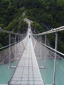
Avignonet is located some 25 km south of Grenoble and 8 km north of Monestier-de-Clermont. Access to the commune is by the A51 autoroute (E712) which passes south through the western arm of the commune and has Exit ![]() 13 Sinard on the commune border. Access to the village is by road D110A from Saint-Martin-de-la-Cluze in the north which comes down the western border of the commune to the village. The D110C goes east from Sinard to the dam through the south of the commune. Apart from the village there are the hamlets of Le Cros and Le Mas in the south-east. There are large forests in the east of the commune with the rest of the commune farmland.[2]
13 Sinard on the commune border. Access to the village is by road D110A from Saint-Martin-de-la-Cluze in the north which comes down the western border of the commune to the village. The D110C goes east from Sinard to the dam through the south of the commune. Apart from the village there are the hamlets of Le Cros and Le Mas in the south-east. There are large forests in the east of the commune with the rest of the commune farmland.[2]
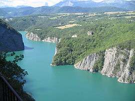
The eastern border of the commune is entirely formed by the Drac river and the large artificial Monteynard lake formed by the dam on the Drac river. Several streams rise in the commune and flow east to the lake including the Ruisseau d'Aiguettas, the Ruisseau de Mitraire, the Ruisseau de la Proche, and the Ruisseau des Vaux which forms part of the northern border.[2]
Neighbouring communes and villages[2]
 |
Miribel-Lanchâtre | Saint-Martin-de-la-Cluze | Monteynard | |
| Saint-Guillaume | |
La Motte-Saint-Martin | ||
| ||||
| | ||||
| Sinard | Treffort | Marcieu |
Administration
List of Successive Mayors[3]
| From | To | Name | Party | Position |
|---|---|---|---|---|
| 2001 | 2007 | Camille Chatelard | ||
| 2007 | 2020 | Jérôme Fauconnier |
(Not all data is known)
Demography
In 2010 the commune had 214 inhabitants. The evolution of the number of inhabitants is known from the population censuses conducted in the commune since 1793. From the 21st century, a census of communes with fewer than 10,000 inhabitants is held every five years, unlike larger communes that have a sample survey every year.[Note 1]
| 1793 | 1800 | 1806 | 1821 | 1831 | 1836 | 1841 | 1846 | 1851 |
|---|---|---|---|---|---|---|---|---|
| 281 | 279 | 291 | 280 | 262 | 285 | 306 | 259 | 262 |
| 1856 | 1861 | 1866 | 1872 | 1876 | 1881 | 1886 | 1891 | 1896 |
|---|---|---|---|---|---|---|---|---|
| 247 | 271 | 266 | 280 | 270 | 233 | 230 | 219 | 209 |
| 1901 | 1906 | 1911 | 1921 | 1926 | 1931 | 1936 | 1946 | 1954 |
|---|---|---|---|---|---|---|---|---|
| 376 | 209 | 203 | 136 | 132 | 143 | 129 | 110 | 112 |
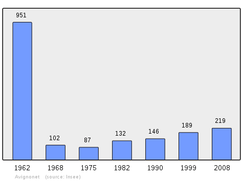
| 1962 | 1968 | 1975 | 1982 | 1990 | 1999 | 2006 | 2010 | - |
|---|---|---|---|---|---|---|---|---|
| 951 | 102 | 87 | 132 | 146 | 189 | 218 | 214 | - |
Sources : Ldh/EHESS/Cassini until 1962, INSEE database from 1968 (population without double counting and municipal population from 2006)
Culture and heritage
Civil heritage
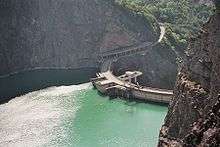
- The Lac de Monteynard-Avignonet with its Dam and Hydro-electricity plant.
- Ruins of the Chateau d'Ars
- The Chateau des marceaux from the 17th century
- Former Chateaux
- Chateau La Cluse
- Chateau des seigneurs du Gua
-
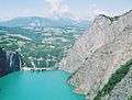
View from the lake
-
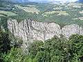
Escarpment on the lake
-
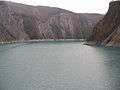
View of the lake
-
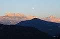
The view east from the lake
-
.jpg)
See also
External links
- Photos of Avignonet (French)
- Bell Towers website (French)
- Avignonet on Lion1906
- Avignonet on Google Maps
- Avignonet on Géoportail, National Geographic Institute (IGN) website (French)
- Avignonet on the 1750 Cassini Map
- Avignonet on the INSEE website (French)
- INSEE (French)
Notes and references
Notes
- ↑ At the beginning of the 21st century, the methods of identification have been modified by Law No. 2002-276 of 27 February 2002, the so-called "law of local democracy" and in particular Title V "census operations" allows, after a transitional period running from 2004 to 2008, the annual publication of the legal population of the different French administrative districts. For communes with a population greater than 10,000 inhabitants, a sample survey is conducted annually, the entire territory of these communes is taken into account at the end of the period of five years. The first "legal population" after 1999 under this new law came into force on 1 January 2009 and was based on the census of 2006.
References
- ↑ Inhabitants of Isère (French)
- 1 2 3 Google Maps
- ↑ List of Mayors of France (French)
| Wikimedia Commons has media related to Avignonet. |