Mens, Isère
| Mens | |
|---|---|
|
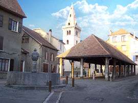
Marketplace | |
 Mens | |
|
Location within Auvergne-Rhône-Alpes region  Mens | |
| Coordinates: 44°49′04″N 5°45′04″E / 44.8178°N 5.7511°ECoordinates: 44°49′04″N 5°45′04″E / 44.8178°N 5.7511°E | |
| Country | France |
| Region | Auvergne-Rhône-Alpes |
| Department | Isère |
| Arrondissement | Grenoble |
| Canton | Mens |
| Intercommunality | Mens |
| Government | |
| • Mayor (2014–2020) | Bernard Coquet |
| Area1 | 28.3 km2 (10.9 sq mi) |
| Population (2011)2 | 1,370 |
| • Density | 48/km2 (130/sq mi) |
| Time zone | CET (UTC+1) |
| • Summer (DST) | CEST (UTC+2) |
| INSEE/Postal code | 38226 / 38710 |
| Elevation | 612–1,929 m (2,008–6,329 ft) |
| Website | http://www.mairie-mens.fr/ |
|
1 French Land Register data, which excludes lakes, ponds, glaciers > 1 km² (0.386 sq mi or 247 acres) and river estuaries. 2 Population without double counting: residents of multiple communes (e.g., students and military personnel) only counted once. | |
Mens is a commune in the Isère department in southeastern France.
Geography
The neighboring communes are: Saint-Sébastien, Saint-Jean-d'Hérans, Cornillon-en-Trièves, Prébois and Saint-Baudille-et-Pipet.
Population
| Historical population | ||
|---|---|---|
| Year | Pop. | ±% |
| 1793 | 2,009 | — |
| 1806 | 1,992 | −0.8% |
| 1821 | 1,828 | −8.2% |
| 1831 | 1,884 | +3.1% |
| 1841 | 2,126 | +12.8% |
| 1851 | 2,093 | −1.6% |
| 1861 | 1,903 | −9.1% |
| 1872 | 1,967 | +3.4% |
| 1881 | 2,083 | +5.9% |
| 1891 | 1,728 | −17.0% |
| 1901 | 1,734 | +0.3% |
| 1911 | 1,539 | −11.2% |
| 1921 | 1,233 | −19.9% |
| 1931 | 1,153 | −6.5% |
| 1946 | 1,123 | −2.6% |
| 1954 | 1,207 | +7.5% |
| 1962 | 1,137 | −5.8% |
| 1968 | 1,090 | −4.1% |
| 1975 | 1,139 | +4.5% |
| 1982 | 1,116 | −2.0% |
| 1990 | 1,129 | +1.2% |
| 1999 | 1,175 | +4.1% |
| 2006 | 1,382 | +17.6% |
| 2011 | 1,370 | −0.9% |
See also
References
| Wikimedia Commons has media related to Mens. |
This article is issued from Wikipedia - version of the 10/28/2016. The text is available under the Creative Commons Attribution/Share Alike but additional terms may apply for the media files.