Le Monestier-du-Percy
| Le Monestier-du-Percy | |
|---|---|
 | |
 Le Monestier-du-Percy | |
|
Location within Auvergne-Rhône-Alpes region  Le Monestier-du-Percy | |
| Coordinates: 44°47′42″N 5°39′34″E / 44.795°N 5.6594°ECoordinates: 44°47′42″N 5°39′34″E / 44.795°N 5.6594°E | |
| Country | France |
| Region | Auvergne-Rhône-Alpes |
| Department | Isère |
| Arrondissement | Grenoble |
| Canton | Clelles |
| Intercommunality | Canton de Clelles |
| Government | |
| • Mayor (2014–2020) | Nathalie Péro |
| Area1 | 15 km2 (6 sq mi) |
| Population (2011)2 | 242 |
| • Density | 16/km2 (42/sq mi) |
| Time zone | CET (UTC+1) |
| • Summer (DST) | CEST (UTC+2) |
| INSEE/Postal code | 38243 / 38930 |
| Elevation |
597–1,896 m (1,959–6,220 ft) (avg. 804 m or 2,638 ft) |
|
1 French Land Register data, which excludes lakes, ponds, glaciers > 1 km² (0.386 sq mi or 247 acres) and river estuaries. 2 Population without double counting: residents of multiple communes (e.g., students and military personnel) only counted once. | |
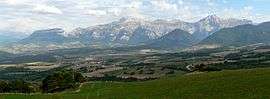
Le Monestier-du-Percy is a commune in the Isère department in southeastern France.
Population
| Historical population | ||
|---|---|---|
| Year | Pop. | ±% |
| 1793 | 273 | — |
| 1806 | 336 | +23.1% |
| 1821 | 331 | −1.5% |
| 1831 | 356 | +7.6% |
| 1841 | 537 | +50.8% |
| 1851 | 523 | −2.6% |
| 1861 | 503 | −3.8% |
| 1872 | 494 | −1.8% |
| 1881 | 507 | +2.6% |
| 1891 | 432 | −14.8% |
| 1901 | 367 | −15.0% |
| 1911 | 343 | −6.5% |
| 1921 | 277 | −19.2% |
| 1931 | 290 | +4.7% |
| 1946 | 229 | −21.0% |
| 1954 | 214 | −6.6% |
| 1962 | 2,023 | +845.3% |
| 1968 | 181 | −91.1% |
| 1975 | 153 | −15.5% |
| 1982 | 146 | −4.6% |
| 1990 | 166 | +13.7% |
| 1999 | 166 | +0.0% |
| 2006 | 210 | +26.5% |
| 2011 | 242 | +15.2% |
See also
References
| Wikimedia Commons has media related to Le Monestier-du-Percy. |
This article is issued from Wikipedia - version of the 10/28/2016. The text is available under the Creative Commons Attribution/Share Alike but additional terms may apply for the media files.