Nantoin
| Nantoin | |
|---|---|
|
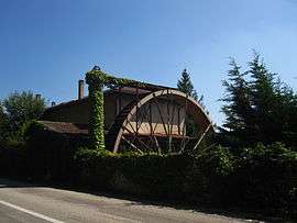
Mill | |
 Nantoin | |
|
Location within Auvergne-Rhône-Alpes region  Nantoin | |
| Coordinates: 45°26′20″N 5°16′15″E / 45.4389°N 5.2708°ECoordinates: 45°26′20″N 5°16′15″E / 45.4389°N 5.2708°E | |
| Country | France |
| Region | Auvergne-Rhône-Alpes |
| Department | Isère |
| Arrondissement | Vienne |
| Canton | Côte-Saint-André |
| Intercommunality | Pays de Bièvre-Liers |
| Government | |
| • Mayor (2014–2020) | Jean-Claude Crétinon |
| Area1 | 9.5 km2 (3.7 sq mi) |
| Population (2011)2 | 441 |
| • Density | 46/km2 (120/sq mi) |
| Time zone | CET (UTC+1) |
| • Summer (DST) | CEST (UTC+2) |
| INSEE/Postal code | 38274 / 38260 |
| Elevation | 430–609 m (1,411–1,998 ft) |
|
1 French Land Register data, which excludes lakes, ponds, glaciers > 1 km² (0.386 sq mi or 247 acres) and river estuaries. 2 Population without double counting: residents of multiple communes (e.g., students and military personnel) only counted once. | |
Nantoin is a commune in the Isère department in southeastern France.
Population
| Historical population | ||
|---|---|---|
| Year | Pop. | ±% |
| 1793 | 487 | — |
| 1806 | 579 | +18.9% |
| 1821 | 540 | −6.7% |
| 1831 | 570 | +5.6% |
| 1841 | 594 | +4.2% |
| 1851 | 616 | +3.7% |
| 1861 | 485 | −21.3% |
| 1872 | 502 | +3.5% |
| 1881 | 473 | −5.8% |
| 1891 | 424 | −10.4% |
| 1901 | 360 | −15.1% |
| 1911 | 339 | −5.8% |
| 1921 | 302 | −10.9% |
| 1931 | 274 | −9.3% |
| 1946 | 247 | −9.9% |
| 1954 | 249 | +0.8% |
| 1962 | 268 | +7.6% |
| 1968 | 233 | −13.1% |
| 1975 | 215 | −7.7% |
| 1982 | 273 | +27.0% |
| 1990 | 300 | +9.9% |
| 1999 | 321 | +7.0% |
| 2006 | 402 | +25.2% |
| 2011 | 441 | +9.7% |
See also
References
| Wikimedia Commons has media related to Nantoin. |
This article is issued from Wikipedia - version of the 3/15/2016. The text is available under the Creative Commons Attribution/Share Alike but additional terms may apply for the media files.