Saint-André-en-Royans
| Saint-André-en-Royans | ||
|---|---|---|
 | ||
| ||
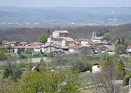
 Saint-André-en-Royans | ||
|
Location within Auvergne-Rhône-Alpes region  Saint-André-en-Royans | ||
| Coordinates: 45°05′12″N 5°20′22″E / 45.0867°N 5.3394°ECoordinates: 45°05′12″N 5°20′22″E / 45.0867°N 5.3394°E | ||
| Country | France | |
| Region | Auvergne-Rhône-Alpes | |
| Department | Isère | |
| Arrondissement | Grenoble | |
| Canton | Canton of Pont-en-Royans | |
| Intercommunality | Bourne à l'Isère | |
| Government | ||
| • Mayor (2014–2020) | Frédéric de Azevedo | |
| Area1 | 10.42 km2 (4.02 sq mi) | |
| Population (2011)2 | 327 | |
| • Density | 31/km2 (81/sq mi) | |
| Time zone | CET (UTC+1) | |
| • Summer (DST) | CEST (UTC+2) | |
| INSEE/Postal code | 38356 / 38680 | |
| Elevation |
224–1,007 m (735–3,304 ft) (avg. 320 m or 1,050 ft) | |
|
1 French Land Register data, which excludes lakes, ponds, glaciers > 1 km² (0.386 sq mi or 247 acres) and river estuaries. 2 Population without double counting: residents of multiple communes (e.g., students and military personnel) only counted once. | ||

Saint-André-en-Royans is a commune in the Isère department in southeastern France.
Population
| Historical population | ||
|---|---|---|
| Year | Pop. | ±% |
| 1793 | 627 | — |
| 1806 | 713 | +13.7% |
| 1821 | 684 | −4.1% |
| 1831 | 700 | +2.3% |
| 1841 | 736 | +5.1% |
| 1851 | 792 | +7.6% |
| 1861 | 699 | −11.7% |
| 1872 | 632 | −9.6% |
| 1881 | 609 | −3.6% |
| 1891 | 574 | −5.7% |
| 1901 | 527 | −8.2% |
| 1911 | 488 | −7.4% |
| 1921 | 456 | −6.6% |
| 1931 | 379 | −16.9% |
| 1946 | 317 | −16.4% |
| 1954 | 322 | +1.6% |
| 1962 | 311 | −3.4% |
| 1968 | 278 | −10.6% |
| 1975 | 239 | −14.0% |
| 1982 | 251 | +5.0% |
| 1990 | 273 | +8.8% |
| 1999 | 297 | +8.8% |
| 2006 | 326 | +9.8% |
| 2011 | 327 | +0.3% |
See also
References
| Wikimedia Commons has media related to Saint-André-en-Royans. |
This article is issued from Wikipedia - version of the 10/28/2016. The text is available under the Creative Commons Attribution/Share Alike but additional terms may apply for the media files.