Saint-Marcellin, Isère
| Saint-Marcellin | ||
|---|---|---|
|
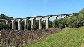
Railroad viaduct | ||
| ||
 Saint-Marcellin | ||
|
Location within Auvergne-Rhône-Alpes region  Saint-Marcellin | ||
| Coordinates: 45°09′14″N 5°19′14″E / 45.1539°N 5.3206°ECoordinates: 45°09′14″N 5°19′14″E / 45.1539°N 5.3206°E | ||
| Country | France | |
| Region | Auvergne-Rhône-Alpes | |
| Department | Isère | |
| Arrondissement | Grenoble | |
| Canton | Saint-Marcellin | |
| Intercommunality | Pays de Saint-Marcellin | |
| Government | ||
| • Mayor (2014–2020) | Jean-Michel Revol | |
| Area1 | 7.81 km2 (3.02 sq mi) | |
| Population (2011)2 | 8,063 | |
| • Density | 1,000/km2 (2,700/sq mi) | |
| Time zone | CET (UTC+1) | |
| • Summer (DST) | CEST (UTC+2) | |
| INSEE/Postal code | 38416 / 38160 | |
| Elevation | 275–300 m (902–984 ft) | |
|
1 French Land Register data, which excludes lakes, ponds, glaciers > 1 km² (0.386 sq mi or 247 acres) and river estuaries. 2 Population without double counting: residents of multiple communes (e.g., students and military personnel) only counted once. | ||

Saint-Marcellin is a commune in the Isère department in southeastern France.
Population
| Historical population | ||
|---|---|---|
| Year | Pop. | ±% |
| 1793 | 3,013 | — |
| 1806 | 3,215 | +6.7% |
| 1821 | 2,780 | −13.5% |
| 1831 | 3,191 | +14.8% |
| 1841 | 3,116 | −2.4% |
| 1851 | 3,460 | +11.0% |
| 1861 | 3,295 | −4.8% |
| 1872 | 3,340 | +1.4% |
| 1881 | 3,250 | −2.7% |
| 1891 | 3,392 | +4.4% |
| 1901 | 3,237 | −4.6% |
| 1911 | 3,348 | +3.4% |
| 1921 | 3,312 | −1.1% |
| 1931 | 3,995 | +20.6% |
| 1946 | 4,308 | +7.8% |
| 1954 | 4,486 | +4.1% |
| 1962 | 5,298 | +18.1% |
| 1968 | 6,186 | +16.8% |
| 1975 | 6,779 | +9.6% |
| 1982 | 6,795 | +0.2% |
| 1990 | 6,696 | −1.5% |
| 1999 | 6,955 | +3.9% |
| 2006 | 7,694 | +10.6% |
| 2011 | 8,063 | +4.8% |
Twin towns
Saint-Marcellin is twinned with:
-
 Grafing, Germany, since 1994
 -
 Fiesso d'Artico, Italy, since 2007
See also
References
| Wikimedia Commons has media related to Saint-Marcellin (Isère). |
This article is issued from Wikipedia - version of the 2/11/2016. The text is available under the Creative Commons Attribution/Share Alike but additional terms may apply for the media files.