Balbins
| Balbins | |
|---|---|
|
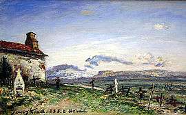
The Balbins Cemetery oil painting in 1888 by Johan Barthold Jongkind | |
 Balbins | |
|
Location within Auvergne-Rhône-Alpes region  Balbins | |
| Coordinates: 45°23′40″N 5°13′00″E / 45.3944°N 5.2167°ECoordinates: 45°23′40″N 5°13′00″E / 45.3944°N 5.2167°E | |
| Country | France |
| Region | Auvergne-Rhône-Alpes |
| Department | Isère |
| Arrondissement | Vienne |
| Canton | Côte-Saint-André |
| Intercommunality | Bièvre-Liers |
| Government | |
| • Mayor (2008–2020) | Anne-Marie Amice |
| Area1 | 7.26 km2 (2.80 sq mi) |
| Population (2010)2 | 386 |
| • Density | 53/km2 (140/sq mi) |
| Time zone | CET (UTC+1) |
| • Summer (DST) | CEST (UTC+2) |
| INSEE/Postal code | 38025 / 38260 |
| Elevation |
347–530 m (1,138–1,739 ft) (avg. 150 m or 490 ft) |
|
1 French Land Register data, which excludes lakes, ponds, glaciers > 1 km² (0.386 sq mi or 247 acres) and river estuaries. 2 Population without double counting: residents of multiple communes (e.g., students and military personnel) only counted once. | |
Balbins is a French commune in the Isère department in the Auvergne-Rhône-Alpes region of south-eastern France.
The inhabitants of the commune are known as Balbinois or Balbinoises.[1]
Geography
Balbins is located some 40 km north-west of Grenoble just west of La Côte-Saint-André. Access to the commune is by the D73 from La Côte-Saint-André which passes through the commune just south of the village and continues west to Penol. The D518A passes through the east of the commune linking the D71 south of La Côte-Saint-André to the D518 north-west of La Côte-Saint-André. The commune is almost entirely farmland with urban area of the village merging with that of Ornacieux.[2]
Neighbouring communes and villages[2]
 |
Ornacieux | | ||
| Penol | |
La Côte-Saint-André | ||
| ||||
| | ||||
| Pajay | Sardieu |
Administration
| From | To | Name | Party | Position |
|---|---|---|---|---|
| 2008 | 2020 | Anne Marie Amice |
(Not all data is known)
Demography
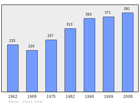
In 2010 the commune had 386 inhabitants. The evolution of the number of inhabitants is known from the population censuses conducted in the commune since 1793. From the 21st century, a census of communes with fewer than 10,000 inhabitants is held every five years, unlike larger communes that have a sample survey every year.[Note 1]
| 1793 | 1800 | 1806 | 1821 | 1831 | 1836 | 1841 | 1846 | 1851 |
|---|---|---|---|---|---|---|---|---|
| 248 | 250 | 342 | 346 | 386 | 396 | 410 | 415 | 389 |
| 1856 | 1861 | 1866 | 1872 | 1876 | 1881 | 1886 | 1891 | 1896 |
|---|---|---|---|---|---|---|---|---|
| 429 | 403 | 387 | 394 | 392 | 405 | 369 | 335 | 326 |
| 1901 | 1906 | 1911 | 1921 | 1926 | 1931 | 1936 | 1946 | 1954 |
|---|---|---|---|---|---|---|---|---|
| 341 | 327 | 316 | 278 | 272 | 308 | 306 | 285 | 256 |
| 1962 | 1968 | 1975 | 1982 | 1990 | 1999 | 2006 | 2010 | - |
|---|---|---|---|---|---|---|---|---|
| 233 | 205 | 257 | 313 | 363 | 371 | 397 | 386 | - |
Sources : Ldh/EHESS/Cassini until 1962, INSEE database from 1968 (population without double counting and municipal population from 2006)
Sites and monuments
- The Buissonnière Tower is the last vestige of the fortified house that stood there; it was the possession of Miribel, Salignon, and Côte Saint-André.
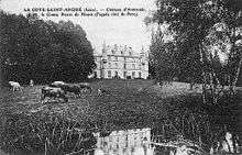
- The Chateau of Armanet was a former Templar fortified house
Notable people linked to the commune
- Félicien de Mons de Savasse, born in the Chateau of Armanet, Knight and Commander of the Order of Malta in 1760.
See also
External links
- Balbins on the old National Geographic Institute website (French)
- Balbins official website (French)
- Balbins on Lion1906
- Balbins on Google Maps
- Balbins on Géoportail, National Geographic Institute (IGN) website (French)
- St Balbin on the 1750 Cassini Map
- Balbins on the INSEE website (French)
- INSEE (French)
Notes and references
Notes
- ↑ At the beginning of the 21st century, the methods of identification have been modified by Law No. 2002-276 of 27 February 2002, the so-called "law of local democracy" and in particular Title V "census operations" allows, after a transitional period running from 2004 to 2008, the annual publication of the legal population of the different French administrative districts. For communes with a population greater than 10,000 inhabitants, a sample survey is conducted annually, the entire territory of these communes is taken into account at the end of the period of five years. The first "legal population" after 1999 under this new law came into force on 1 January 2009 and was based on the census of 2006.
References
- ↑ Inhabitants of Isère (French)
- 1 2 Google Maps
- ↑ List of Mayors of France (French)
| Wikimedia Commons has media related to Balbins. |