Moirans
For the French wine grape, see Moirans (grape).
| Moirans | ||
|---|---|---|
|
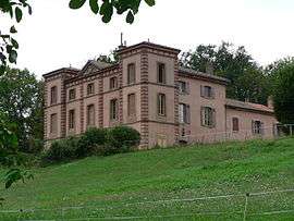
Chateau of La Motte | ||
| ||
 Moirans | ||
|
Location within Auvergne-Rhône-Alpes region  Moirans | ||
| Coordinates: 45°19′33″N 5°33′55″E / 45.3258°N 5.5653°ECoordinates: 45°19′33″N 5°33′55″E / 45.3258°N 5.5653°E | ||
| Country | France | |
| Region | Auvergne-Rhône-Alpes | |
| Department | Isère | |
| Arrondissement | Grenoble | |
| Canton | Rives | |
| Intercommunality | Pays Voironnais | |
| Government | ||
| • Mayor (2014–2020) | Gérard Simonet | |
| Area1 | 20.06 km2 (7.75 sq mi) | |
| Population (2011)2 | 7,743 | |
| • Density | 390/km2 (1,000/sq mi) | |
| Time zone | CET (UTC+1) | |
| • Summer (DST) | CEST (UTC+2) | |
| INSEE/Postal code | 38239 / 38430 | |
| Elevation | 180–341 m (591–1,119 ft) | |
|
1 French Land Register data, which excludes lakes, ponds, glaciers > 1 km² (0.386 sq mi or 247 acres) and river estuaries. 2 Population without double counting: residents of multiple communes (e.g., students and military personnel) only counted once. | ||

- For the town in Jura, see Moirans-en-Montagne.
Moirans is a commune in the Isère department in southeastern France.
Population
| Historical population | ||
|---|---|---|
| Year | Pop. | ±% |
| 1793 | 2,006 | — |
| 1806 | 2,482 | +23.7% |
| 1821 | 2,742 | +10.5% |
| 1831 | 2,765 | +0.8% |
| 1841 | 2,769 | +0.1% |
| 1851 | 2,765 | −0.1% |
| 1861 | 2,789 | +0.9% |
| 1872 | 2,844 | +2.0% |
| 1881 | 3,227 | +13.5% |
| 1891 | 3,186 | −1.3% |
| 1901 | 3,479 | +9.2% |
| 1911 | 3,805 | +9.4% |
| 1921 | 3,517 | −7.6% |
| 1931 | 3,908 | +11.1% |
| 1946 | 3,418 | −12.5% |
| 1954 | 3,840 | +12.3% |
| 1962 | 3,959 | +3.1% |
| 1968 | 4,536 | +14.6% |
| 1975 | 5,106 | +12.6% |
| 1982 | 6,313 | +23.6% |
| 1990 | 7,133 | +13.0% |
| 1999 | 7,495 | +5.1% |
| 2006 | 7,860 | +4.9% |
| 2011 | 7,743 | −1.5% |
See also
References
| Wikimedia Commons has media related to Moirans (Isère). |
This article is issued from Wikipedia - version of the 3/15/2016. The text is available under the Creative Commons Attribution/Share Alike but additional terms may apply for the media files.