Varces-Allières-et-Risset
| Varces-Allières-et-Risset | |
|---|---|
|
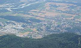
Seen from the Pic St. Michel | |
 Varces-Allières-et-Risset | |
|
Location within Auvergne-Rhône-Alpes region  Varces-Allières-et-Risset | |
| Coordinates: 45°05′15″N 5°37′40″E / 45.0875°N 5.6278°ECoordinates: 45°05′15″N 5°37′40″E / 45.0875°N 5.6278°E | |
| Country | France |
| Region | Auvergne-Rhône-Alpes |
| Department | Isère |
| Arrondissement | Grenoble |
| Canton | Vif |
| Intercommunality | Grenoble Alpes Métropole |
| Government | |
| • Mayor (2014–2020) | Jean-Luc Corbet |
| Area1 | 21 km2 (8 sq mi) |
| Population (2012)2 | 6,583 |
| • Density | 310/km2 (810/sq mi) |
| Time zone | CET (UTC+1) |
| • Summer (DST) | CEST (UTC+2) |
| INSEE/Postal code | 38524 / 38760 |
| Elevation | 247–1,960 m (810–6,430 ft) |
|
1 French Land Register data, which excludes lakes, ponds, glaciers > 1 km² (0.386 sq mi or 247 acres) and river estuaries. 2 Population without double counting: residents of multiple communes (e.g., students and military personnel) only counted once. | |
Varces-Allières-et-Risset is a commune in the Isère department in southeastern France.
Population
| Historical population | ||
|---|---|---|
| Year | Pop. | ±% |
| 1793 | 537 | — |
| 1806 | 670 | +24.8% |
| 1821 | 735 | +9.7% |
| 1831 | 722 | −1.8% |
| 1841 | 745 | +3.2% |
| 1851 | 733 | −1.6% |
| 1861 | 738 | +0.7% |
| 1872 | 678 | −8.1% |
| 1881 | 703 | +3.7% |
| 1891 | 720 | +2.4% |
| 1901 | 621 | −13.7% |
| 1911 | 611 | −1.6% |
| 1921 | 586 | −4.1% |
| 1931 | 675 | +15.2% |
| 1946 | 639 | −5.3% |
| 1954 | 808 | +26.4% |
| 1962 | 2,152 | +166.3% |
| 1968 | 2,296 | +6.7% |
| 1975 | 2,809 | +22.3% |
| 1982 | 3,576 | +27.3% |
| 1990 | 4,592 | +28.4% |
| 1999 | 5,341 | +16.3% |
| 2006 | 6,509 | +21.9% |
| 2012 | 6,583 | +1.1% |
See also
References
| Wikimedia Commons has media related to Varces-Allières-et-Risset. |
This article is issued from Wikipedia - version of the 2/12/2016. The text is available under the Creative Commons Attribution/Share Alike but additional terms may apply for the media files.