La Balme-les-Grottes
| La Balme-les-Grottes | ||
|---|---|---|
|
The Lavoir (Public laundry) | ||
| ||
 La Balme-les-Grottes | ||
|
Location within Auvergne-Rhône-Alpes region  La Balme-les-Grottes | ||
| Coordinates: 45°51′12″N 5°20′13″E / 45.8533°N 5.3369°ECoordinates: 45°51′12″N 5°20′13″E / 45.8533°N 5.3369°E | ||
| Country | France | |
| Region | Auvergne-Rhône-Alpes | |
| Department | Isère | |
| Arrondissement | La Tour-du-Pin | |
| Canton | Crémieu | |
| Intercommunality | Isle-Crémieu | |
| Government | ||
| • Mayor (2014–2020) | Martine Gabeure | |
| Area1 | 14.61 km2 (5.64 sq mi) | |
| Population (2010)2 | 915 | |
| • Density | 63/km2 (160/sq mi) | |
| Time zone | CET (UTC+1) | |
| • Summer (DST) | CEST (UTC+2) | |
| INSEE/Postal code | 38026 / 38390 | |
| Elevation |
192–383 m (630–1,257 ft) (avg. 210 m or 690 ft) | |
|
1 French Land Register data, which excludes lakes, ponds, glaciers > 1 km² (0.386 sq mi or 247 acres) and river estuaries. 2 Population without double counting: residents of multiple communes (e.g., students and military personnel) only counted once. | ||
.JPG)
La Balme-les-Grottes is a French commune in the Isère department in the Auvergne-Rhône-Alpes region of south-eastern France.
The inhabitants of the commune are known as Balmolans or Balmolanes.[1]
Geography
La Balme-des-Grottes is located some 32 km east by north-east of Lyon and 11 km south of Ambérieu-en-Bugey on the right bank of the Rhône. The Rhône also forms the departmental border between Isère and Ain. Access to the commune is by the D65 road from Leyrieu in the south which passes through the length of the commune and the village and continues north to join the D1075 west of Vertrieu. The D52B branches from the D65 in the commune and goes south to Saint-Baudille-de-la-Tour. The D52C also branches from the D65 at the same intersection and goes south-east to Charette. The commune is mixed forest and farmland with dense forests in the north-east.[2]
The Rhône river forms the entire western border of the commune with no crossing points anywhere in the commune. The commune is covered by a network of canals linked to the Rhône and the Ruisseau de Laye which is a minor loop of the Rhône.[2]
Neighbouring communes and villages[2]
 |
Sainte-Julie | Lagnieu | Vertrieu | |
| Blyes | |
Parmilieu | ||
| ||||
| | ||||
| Saint-Vulbas | Hières-sur-Amby | Charette |
History
Neanderthal men from the Middle Paleolithic period left flint tools and food scraps in the La Balme caves. Around 15000/13000 BC, in the late Upper Paleolithic, Cro-Magnon hunters did the same in the shelter of the cave: flints and bones of reindeer, ibex, aurochs, and horses have been found.
From about 4000 BC, Neolithic farmers colonised the region leaving their polished axes, flints, and pots in Louvaresse and Travers. Collective graves and vases have also been found in the cave from that time. It was especially at the end of the Bronze Age that they left very important remains (1250-950 BC): numerous tombs with cremation urns and animal offerings have been found in crevices and under boulders in a large part of the cave. It is an underground necropolis of the Urnfield culture, now well-known to European specialists for its wealth of ceramic vases from a full scientific publication.[3]
Part of the archaeological material from all eras is displayed in the Heritage House at Hières-sur-Amby where it was sent in 1985 by the excavators.
Heraldry
_38.svg.png) |
The official status of the blazon remains to be determined.
Blazon: |
Administration
| From | To | Name | Party | Position |
|---|---|---|---|---|
| 2001 | 2014 | Didier Chapit | ||
| 2014 | 2020 | Martine Gabeure |
(Not all data is known)
Demography
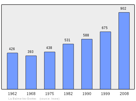
In 2010 the commune had 915 inhabitants. The evolution of the number of inhabitants is known from the population censuses conducted in the commune since 1793. From the 21st century, a census of communes with fewer than 10,000 inhabitants is held every five years, unlike larger communes that have a sample survey every year.[Note 1]
| 1793 | 1800 | 1806 | 1821 | 1831 | 1836 | 1841 | 1846 | 1851 |
|---|---|---|---|---|---|---|---|---|
| 514 | 558 | 568 | 654 | 644 | 741 | 850 | 892 | 912 |
| 1856 | 1861 | 1866 | 1872 | 1876 | 1881 | 1886 | 1891 | 1896 |
|---|---|---|---|---|---|---|---|---|
| 869 | 863 | 819 | 759 | 649 | 608 | 588 | 602 | 510 |
| 1901 | 1906 | 1911 | 1921 | 1926 | 1931 | 1936 | 1946 | 1954 |
|---|---|---|---|---|---|---|---|---|
| 461 | 452 | 446 | 405 | 384 | 345 | 310 | 330 | 408 |
| 1962 | 1968 | 1975 | 1982 | 1990 | 1999 | 2006 | 2010 | - |
|---|---|---|---|---|---|---|---|---|
| 426 | 393 | 438 | 531 | 588 | 675 | 814 | 915 | - |
Sources : Ldh/EHESS/Cassini until 1962, INSEE database from 1968 (population without double counting and municipal population from 2006)
Economy
Culture and heritage
Civil heritage
The commune has many buildings and sites that are registered as historical monuments:
- Houses (16th-20th century)
 [6]
[6] - The Town Hall / School at Route de Lagneu (1882)[7]
- The Chateau de Salette (13th century).[8] The remaining buildings of the former Carthusian monastery of Salette. The facades and roofs of the chateau are from the 19th century. In October 1299 Dauphin Humbert I of Viennois founded a monastery for women of which three buildings remain. During the French Revolution the monastery was sold and is home for some time to an earthenware factory. The chateau was built around 1870-1880 and preserves some decorations from that time.
- The Chateau d'Amblérieu (ruins) (14th century)[9]
- The War Memorial (20th century)[10]
- Mills (17th-20th century)[11]
- A Lavoir (Public laundry) (1879)[12]
- The Chateau de La Serve (1818)[13]
- The Chateau Delphinal (13th century)[14]
Religious heritage
The commune has several religious buildings and structures that are registered as historical monuments:
- A Wayside Cross at Rue des Grottes (17th century)[15]
- The Favre family Tomb (20th century)[16]
- The Tomb of Eudoxie Gigard (19th century)[17]
- The Péricaud family Tomb (19th century)[18]
- The Cemetery (1865)[19]
- The Priory of Notre-Dame (1660)[20]
- The Chapel of Notre-Dame of the Grotto (12th century)[21] The Chapel contains a large number of items that are registered as historical objects. For a complete list with links to descriptions (in French) click here.
- The Parish Church of Saint Peter (12th century)[22] The Church contains a large number of items that are registered as historical objects. For a complete list with links to descriptions (in French) click here.
Environmental heritage
.JPG)
- The Grotte de La Balme (La Balme Cave) is one of the Seven Wonders of Dauphiné. It is a formation of an "amphitheatre of small basins". The caves were a hideout for Louis Mandrin. They were visited by François I and contain an apochyphal portrait of him. The caves contain several items that are registered as historical objects:
- A Sarcophagus (Gallo-Roman)
 [23]
[23] - A Funeral Stele (Gallo-Roman)[24]
- A Commemorative Plaque (Gallo-Roman)[25]
- A Sarcophagus (Gallo-Roman)
Notable people linked to the commune
- Laurent Clerc, founder of the first school for the Deaf in North America, born on 26 December 1785 in La Balme-les-Grottes.
- Jean Roux, priest of La Balme, left a pre-Revolutionary "Journal" of great interest.[26]
See also
External links
- La Balme-les-Grottes official website (French)
- La Balme-les-Grottes on Lion1906
- La Balme-les-Grottes on Google Maps
- La Balme-les-Grottes on Géoportail, National Geographic Institute (IGN) website (French)
- la Balme on the 1750 Cassini Map
- La Balme-les-Grottes on the INSEE website (French)
- INSEE (French)
Notes and references
Notes
- ↑ At the beginning of the 21st century, the methods of identification have been modified by Law No. 2002-276 of 27 February 2002, the so-called "law of local democracy" and in particular Title V "census operations" allows, after a transitional period running from 2004 to 2008, the annual publication of the legal population of the different French administrative districts. For communes with a population greater than 10,000 inhabitants, a sample survey is conducted annually, the entire territory of these communes is taken into account at the end of the period of five years. The first "legal population" after 1999 under this new law came into force on 1 January 2009 and was based on the census of 2006.
References
- ↑ Inhabitants of Isère (French)
- 1 2 3 Google Maps
- ↑ La Grotte de la Balme (French)
- ↑ List of Mayors of France (French)
- ↑ Copainspro website (French)
- ↑ Ministry of Culture, Mérimée IA38000343 House 1 at D65 IA38000345 House 2 at D65 IA38000344 House 3 at D65 IA38000576 Houses IA38000128 Farmhouse at la Brosse (French)
- ↑ Ministry of Culture, Mérimée IA38000051 Town Hall / School at Route de Lagneu (French)
- ↑ Ministry of Culture, Mérimée PA38000001 Chateau de Salette (French)

- ↑ Ministry of Culture, Mérimée PA00117117 IA38000036 Chateau d'Amblérieu (French)
- ↑ Ministry of Culture, Mérimée IA38000577 War Memorial (French)
- ↑ Ministry of Culture, Mérimée IA38000342 Moulin du Pré du Moulin at Amblérieu IA38000341 Flour Mill at Travers (French)
- ↑ Ministry of Culture, Mérimée IA38000339 Lavoir (French)
- ↑ Ministry of Culture, Mérimée PA38000334 Chateau de La Serve (French)
- ↑ Ministry of Culture, Mérimée IA38000037 Chateau Delphinal (French)
- ↑ Ministry of Culture, Mérimée IA38000340 Wayside Cross at Rue des Grottes (French)
- ↑ Ministry of Culture, Mérimée IA38000338 Favre family tomb (French)
- ↑ Ministry of Culture, Mérimée IA38000337 Tomb of Eudoxie Gigard (French)
- ↑ Ministry of Culture, Mérimée IA38000336 Péricaud family tomb (French)
- ↑ Ministry of Culture, Mérimée IA38000335 Cemetery (French)
- ↑ Ministry of Culture, Mérimée IA38000318 Priory of Notre-Dame (French)
- ↑ Ministry of Culture, Mérimée IA38000315 Chapel of Notre-Dame of the Grotto (French)
- ↑ Ministry of Culture, Mérimée IA38000115 Parish Church of Saint Peter (French)
- ↑ Ministry of Culture, Palissy PM38000014 Sarcophagus (French)
- ↑ Ministry of Culture, Palissy PM38000013 Funeral Stele (French)
- ↑ Ministry of Culture, Palissy PM38000012 Commemorative Plaque (French)
- ↑ Marius Riollet: "Review of tre History of Lyon" Vol. X, 1911 (French)
| Wikimedia Commons has media related to La Balme-les-Grottes. |