Saint-Égrève
| Saint-Égrève | |
|---|---|
 | |
 Saint-Égrève | |
|
Location within Auvergne-Rhône-Alpes region  Saint-Égrève | |
| Coordinates: 45°13′57″N 5°41′01″E / 45.2325°N 5.6836°ECoordinates: 45°13′57″N 5°41′01″E / 45.2325°N 5.6836°E | |
| Country | France |
| Region | Auvergne-Rhône-Alpes |
| Department | Isère |
| Arrondissement | Grenoble |
| Canton | Saint-Égrève |
| Intercommunality | Grenoble Alpes Métropole |
| Government | |
| • Mayor (2014–2020) | Catherine Kamowski |
| Area1 | 11 km2 (4 sq mi) |
| Population (2011)2 | 16,047 |
| • Density | 1,500/km2 (3,800/sq mi) |
| Time zone | CET (UTC+1) |
| • Summer (DST) | CEST (UTC+2) |
| INSEE/Postal code | 38382 / 38120 |
| Elevation |
198–1,299 m (650–4,262 ft) (avg. 202 m or 663 ft) |
|
1 French Land Register data, which excludes lakes, ponds, glaciers > 1 km² (0.386 sq mi or 247 acres) and river estuaries. 2 Population without double counting: residents of multiple communes (e.g., students and military personnel) only counted once. | |
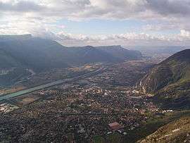
Saint-Égrève is a commune in the Isère department in southeastern France.
Population
| Historical population | ||
|---|---|---|
| Year | Pop. | ±% |
| 1793 | 620 | — |
| 1806 | 789 | +27.3% |
| 1821 | 1,185 | +50.2% |
| 1831 | 1,240 | +4.6% |
| 1841 | 1,273 | +2.7% |
| 1851 | 1,269 | −0.3% |
| 1861 | 1,587 | +25.1% |
| 1872 | 1,883 | +18.7% |
| 1881 | 2,301 | +22.2% |
| 1891 | 2,507 | +9.0% |
| 1901 | 2,660 | +6.1% |
| 1911 | 2,997 | +12.7% |
| 1921 | 3,013 | +0.5% |
| 1931 | 3,628 | +20.4% |
| 1946 | 3,250 | −10.4% |
| 1954 | 4,305 | +32.5% |
| 1962 | 7,641 | +77.5% |
| 1968 | 11,445 | +49.8% |
| 1975 | 14,246 | +24.5% |
| 1982 | 14,363 | +0.8% |
| 1990 | 15,891 | +10.6% |
| 1999 | 15,517 | −2.4% |
| 2006 | 15,375 | −0.9% |
| 2011 | 16,047 | +4.4% |
Twin towns
Saint-Égrève is twinned with:
-
 Karben, Germany, since 1974
 -
 Mińsk Mazowiecki, Poland, since 1991
 -
 Krnov, Czech Republic, since 1991
 -
 Cori, Lazio, Italy, since 1999
See also
References
| Wikimedia Commons has media related to Saint-Égrève. |
This article is issued from Wikipedia - version of the 2/28/2016. The text is available under the Creative Commons Attribution/Share Alike but additional terms may apply for the media files.