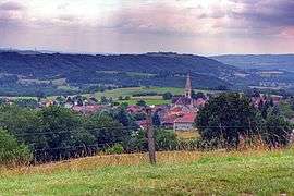
Sermérieu
| Sermérieu | |
|---|---|
 | |
 Sermérieu | |
|
Location within Auvergne-Rhône-Alpes region  Sermérieu | |
| Coordinates: 45°40′20″N 5°24′36″E / 45.6722°N 5.41°ECoordinates: 45°40′20″N 5°24′36″E / 45.6722°N 5.41°E | |
| Country | France |
| Region | Auvergne-Rhône-Alpes |
| Department | Isère |
| Arrondissement | La Tour-du-Pin |
| Canton | Morestel |
| Intercommunality | Pays des Couleurs |
| Government | |
| • Mayor (2014–2020) | Alexandre Bolleau |
| Area1 | 17.14 km2 (6.62 sq mi) |
| Population (2011)2 | 1,498 |
| • Density | 87/km2 (230/sq mi) |
| Time zone | CET (UTC+1) |
| • Summer (DST) | CEST (UTC+2) |
| INSEE/Postal code | 38483 / 38510 |
| Elevation |
223–385 m (732–1,263 ft) (avg. 298 m or 978 ft) |
|
1 French Land Register data, which excludes lakes, ponds, glaciers > 1 km² (0.386 sq mi or 247 acres) and river estuaries. 2 Population without double counting: residents of multiple communes (e.g., students and military personnel) only counted once. | |
Sermérieu is a commune in the Isère department in southeastern France.
Population
| Historical population | ||
|---|---|---|
| Year | Pop. | ±% |
| 1793 | 1,031 | — |
| 1806 | 1,205 | +16.9% |
| 1821 | 1,308 | +8.5% |
| 1831 | 1,423 | +8.8% |
| 1841 | 1,445 | +1.5% |
| 1851 | 1,552 | +7.4% |
| 1861 | 1,431 | −7.8% |
| 1872 | 1,357 | −5.2% |
| 1881 | 1,354 | −0.2% |
| 1891 | 1,297 | −4.2% |
| 1901 | 1,173 | −9.6% |
| 1911 | 1,064 | −9.3% |
| 1921 | 913 | −14.2% |
| 1931 | 761 | −16.6% |
| 1946 | 751 | −1.3% |
| 1954 | 640 | −14.8% |
| 1962 | 682 | +6.6% |
| 1968 | 639 | −6.3% |
| 1975 | 588 | −8.0% |
| 1982 | 756 | +28.6% |
| 1990 | 9,356 | +1137.6% |
| 1999 | 1,168 | −87.5% |
| 2006 | 1,425 | +22.0% |
| 2011 | 1,498 | +5.1% |
See also
References
| Wikimedia Commons has media related to Sermérieu. |
This article is issued from Wikipedia - version of the 10/28/2016. The text is available under the Creative Commons Attribution/Share Alike but additional terms may apply for the media files.