Bois Brule Creek (Cinque Hommes Creek)
| Bois Brule Creek | |
| Stream | |
 | |
| Name origin: French for “Burnt Wood” | |
| Country | United States |
|---|---|
| State | Missouri |
| Mouth | Mississippi River |
| - location | Mississippi River, MO |
| - elevation | 354 ft (108 m) |
| - coordinates | 37°47′20″N 89°44′50″W / 37.78889°N 89.74722°WCoordinates: 37°47′20″N 89°44′50″W / 37.78889°N 89.74722°W |
Bois Brule Creek is a tributary of Cinque Hommes Creek in Perry County, Missouri.
Name
The name Bois Brule (French: Bois Brûlé) means “Burnt Wood” was given to both the creek and the flood plain by early French settlers. The name was applied by the French to describe a burnt tract of forest found in the area.[1]
Physical geography
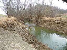
Bois Brule Creek is a tributary of Cinque Hommes Creek and flows into Cinque Hommes Creek in Bois Brule Bottoms north of Menfro, Missouri at 354 feet (108 meters).[2] The stream’s feature ID is 741394.[3][4] A number of drainage ditches empty into Bois Brule Creek, draining excess water out of Bois Brule Bottoms.[5]
Tributaries
- Blue Spring Branch
- McClanahan Creek
Cultural geography
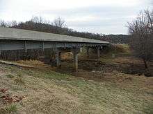
Bridges that traverse Bois Brule Creek are the Bois Brule Creek CR 212 Bridge, the Bois Brule Creek CR 216 Bridge, the Route E Mystery Bridge, and the Route 51 Bois Brule Bridge at McBride, Missouri.[6]
History
The first European settlers in the vicinity of Bois Brule Creek were French colonial settlers. However, in 1798, a number of Irish Catholics were given permission to settle in the Bois Brule area. The Bois Brule Township was organized in 1821 and named after the creek and bottoms, and was one of Perry County’s original three townships.[7]
Communities
See also
References
- ↑ Perry County Place Names. State Historical Society of Missouri.
- ↑ Mytopo.com http://www.mytopo.com/locations/index.cfm?fid=714493
- ↑ Missouri.hometownlocator.com http://missouri.hometownlocator.com/maps/feature-map,ftc,1,fid,741394,n,bois%20brule%20creek.cfm/
- ↑ Lat-Long.com http://www.lat-long.com/Latitude-Longitude-714493-Missouri-Bois_Brule_Creek.html
- ↑ U.S. Government Printing Office (1916). "Field Operations of the Bureau of Soils, Volume 15".
- ↑ Bridgehunter.com http://bridgehunter.com/mo/perry/
- ↑ Michael C. O'Laughlin (2007). "Missouri Irish, the Original History of the Irish in St. Louis; Kansas City; the Irish Wilderness and More: From the Earliest Times to the Current Day in America". ISBN 9780940134263.
Geographical features of Perry County, Missouri | ||
|---|---|---|
| Rivers | 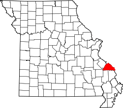 | |
| Streams | ||
| Capes | ||
| Islands | ||
| Alluvial plains | ||
| Wildlife refuges | ||
| Conservation areas | ||
Municipalities and communities of Perry County, Missouri, United States | ||
|---|---|---|
| Cities | | |
| Villages | ||
| Townships | ||
| CDP | ||
| Other unincorporated communities | ||
| Abandoned villages | ||
| Footnotes | ‡This populated place also has portions in an adjacent county or counties | |