Perryville, Missouri
| Perryville, Missouri | |
|---|---|
| City | |
|
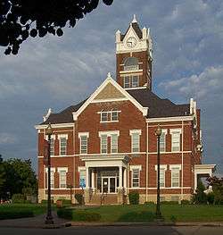
Perry County Court House | |
 Location of Perryville, Missouri | |
| Coordinates: 37°43′34″N 89°52′18″W / 37.72611°N 89.87167°WCoordinates: 37°43′34″N 89°52′18″W / 37.72611°N 89.87167°W | |
| Country | United States |
| State | Missouri |
| County | Perry |
| Township | Central |
| Incorporated | 1856 |
| Area[1] | |
| • Total | 7.96 sq mi (20.62 km2) |
| • Land | 7.80 sq mi (20.20 km2) |
| • Water | 0.16 sq mi (0.41 km2) |
| Elevation | 581 ft (177 m) |
| Population (2010)[2] | |
| • Total | 8,225 |
| • Estimate (2012[3]) | 8,262 |
| • Density | 1,054.5/sq mi (407.1/km2) |
| Time zone | Central (CST) (UTC-6) |
| • Summer (DST) | CDT (UTC-5) |
| ZIP codes | 63775, 63776, 63783 |
| Area code(s) | 573 |
| FIPS code | 29-57116[4] |
| GNIS feature ID | 0724239[5] |
| Perryville has a Mayfest once a year | |
Perryville is a city in Perry County, Missouri, United States. The population was 8,225 at the 2010 census. Perryville is the county seat of Perry County.[6]
History
18th century
In the 18th century the area of present-day Perryville was under French and Spanish colonial administration. The region was part of the New Bourbon district (a sub-district of the Ste. Genevieve district) of the Upper Louisiana colony, also known as the Illinois Country. Looking to expand the population, Spanish authorities agreed to allow American Catholics settle in Upper Louisiana. A Maryland Catholic and descendant of Lord Baltimore's Catholic colony, Isidore Moore, along with a number of other Maryland Catholics, who had settled in Marion, Nelson and Washington counties in Kentucky in the 1780s, looked to take up the invitation. Twenty-year-old Isidore Moore scouted both sides of the Illinois Country in 1792, at which time his visit to Kaskaskia had discouraged him, and again in 1797 when he visited St. Louis and the grasslands south of Ste. Genevieve. In 1800, Moore once again scouted the grasslands west of the Mississippi, which he found favorable. This grassland would later become known as "The Barrens" due to the open grassland with few trees.[7]
19th century
On February 9, 1801, Isidore Moore received a concession from Spanish authorities and returned to Kentucky for his family and other families closely interrelated through marriage: the Tuckers, Haydens, Cissells, Hagans, Laytons, Brewers, and others. Some of these families had already arrived in the winter of 1803-1804 had built cabins to establish settlement rights.[7]
It is not clear why or how Perryville came to be selected as the county seat of Perry County, Missouri, but the site was selected by Robert T. Brown, Joseph Tucker, and Thomas Riney, who had been appointed to select the seat of justice for Perry County.[8] On August 7, 1821, Bernard Layton deeded 51 acres (210,000 m2) to the commissioners in exchange for one town lot. Fifty-three of the 99 town lots were sold for $1,486.25, which was used to build the first courthouse. The one existing today is actually the third such structure. It was built in 1904 at a cost of $30,000. Perryville and Perry County were named for Commodore Oliver Hazard Perry, Naval hero of the War of 1812.[9][10]
One of the long time stories concerning early Perryville is that the first store in Perryville, a log structure, was built by Jean Ferdinand Rozier on the north side of the square.[7] This is not true. Rozier had a store in Perryville but not the first. It was on the north side of the square on Lot 57 which was not even owned by anyone before 1829 and Ferdinand Rozier bought the property in 1835. Barnabas Burns had a storehouse on the east side of the square by the late 1820s. Levi Block built his two story brick building, which is still standing, by 1830.[11] The upper story serves as the first town hall for the small settlement. Perryville was first incorporated in 1837, but records show the incorporation was allowed to lapse. In the early 19th century, Henry Burns built a home on South Spring Street. Later, William P. Faherty bought the house, which is now a museum operated by the Perry County Historical Society.
As both merchandisers and consumers grew in sophistication, so did the types of establishments in the county. Built in 1843, the Hoose Hotel, often called the "white house",[6] was a prominent structure in early commercial days. The Hoose Hotel was located at the site presently occupied by Eagle Bank and Trust Co. and The Total Package and served as a hotel, a brewery and an auction block.
In 1856, the town was again incorporated and by 1874 it had its first fire engine. Fourth Class City status was attained in 1879 and the following year Charles A. Weber was elected its first mayor.[12] With the building of the Chester, Perryville and Ste. Genevieve Railway, prosperity came.
Largely because of its role as the seat of county government and because of its central location, Perryville began to develop as the major commercial and service center in Perry County. The population jumped from 897 in 1890 to 1275 in 1900. In 1893 the telephone arrived.[13]
20th century
The first horseless carriage, deemed a "locomobile" by The Perry County Republican newspaper, was reported in Perryville in 1903. The first power plant was built in 1913 to provide Perryville with electric lights. This building is currently being renovated by the Perry Art Alliance. In 1923, the Chamber of Commerce was formed, and Perryville launched its first industrial development offensive by raising $100,000 to build an industrial building in the hope of persuading International Shoe Company in St. Louis to open a Perryville plant. The venture was successful and the opening of the International plant spurred a cycle of growth which included the paving of city streets and a host of new businesses and city services.
In 1940, a second International production facility, known as the Kiefner Branch, opened in Perryville. However, in 1964 an economic downturn forced the closing of International's original Magnolia branch plant.
The loss of 250 jobs in the Magnolia plant closing heightened interest in a more diverse industrial base. The efforts of the Chamber of Commerce, Perryville Development Corporation, and city officials led to the development of the Perryville Industrial Park and the establishment of an Enterprise Zone. The City of Perryville hired its first City Administrator in 1976. The Perry County Industrial Development Authority was established in 1983. Over time, tenants in the Perryville Industrial Park include TG Missouri Corporation, T-N-T Plastics, Wilkes Integrated Packaging, Falcon Foam, Industrial Foam Products, Perry County Sheltered Workshop and Missouri Corrugated Box.
21st century
Among contemporary manufacturers in Perryville is Gilster-Mary Lee Corporation, with two facilities (a 125,000-square-foot (11,600 m2) baking mix plant and a 185,000-square-foot (17,200 m2) breakfast cereal plant).[14] Also in the Perrville area are
- Sabreliner Corporation, a company which provides maintenance and overhauling for both military and business jet aircraft engines;
- Seguin Moreau, a French wine barrel manufacturer, that mills barrel staves and heads from Perry County's white oak forests to supply its cooperage in Napa, California. The cooperage uses the wood it gets from Perry County to produce American oak wine barrels for the international wine industry; and
- TG Missouri Corporation, a subsidiary of the Japanese company Toyoda Gosei, manufactures airbags, steering wheels and interior trim pieces for automobile manufacturers, most notably Toyota.
- BBL Buildings and Components and Stark Truss, both of whom manufacture building trusses for commercial and residential construction;
- Bierk Farms Gravel Company, who screens and sells creek gravel in various sizes.
Historic places
Perryville is home to three nationally registered historic places, including two houses and a historic district:
| [15] | Name on the Register | Image | Date listed[16] | Location | Description |
|---|---|---|---|---|---|
| 1 | [[Doerr-Brown House]] | Upload image | (#80002388) |
17 E. St. Joseph St. 37°43′26″N 89°51′40″W / 37.723889°N 89.861111°WDoerr-Brown House) |
|
| 2 | [[St. Mary's of the Barrens Historic District]] | Upload image | (#95001041) |
SW of junction of W. St. Joseph St. and MO 51 37°43′34″N 89°53′14″W / 37.726111°N 89.887222°WSt. Mary's of the Barrens Historic District) |
Home to St. Mary's of the Barrens, founded by Bishop Joseph Rosati in the 19th century |
| 3 | Shelby-Nicholson-Schindler House | Upload image | (#74001088) |
701 W. St. Joseph St. 37°43′30″N 89°52′15″W / 37.725°N 89.870833°W |
Community
The traditional heart of Perryville is the courthouse square. As its name suggests, the centerpiece of the square is the Perry County Courthouse. The main square has decorative sidewalks, "Washington" style light fixtures and decorative tree plantings.[17] The Perry Park Center, located in the city park, features an aquatics center, gymnasium, performing arts center, movie theatre, library, and sports facilities.[18] Perry County Memorial Hospital is the health provider for the city and county. Two festivals are held annually in Perryville, Mayfest which is held on the courthouse square in May, and the St. Vincent de Paul Seminary Picnic which is held on the seminary fairgrounds each August.[19][20] Two of the largest employers in the city are TG Missouri, a division of Toyoda Gosei, and Gilster-Mary Lee.
Government
Perryville has a Mayor / City Council form of government. The current Mayor is Ken Baer.[21] The city council consists of six aldermen, two from each of three wards. Each is elected for two-year terms.
Education
Perryville is served by Perry County School District No. 32 (PK-12) as well as two private parochial school systems: St. Vincent dePaul Catholic School (including St. Vincent High School) and Immanuel Lutheran School (PK-8).
Religion
Perryville is home to a number of churches, of which three of the largest churches are St. Vincent's de Paul Roman Catholic Church, St. Mary's of the Barrens Roman Catholic Church, Immanuel Lutheran Church, the First Presbyterian Church, First Baptist Church, Calvery Baptist Church, United Methodist Church, Agape Christian Assembly of God Church, First Assembly of God Church, Christ of Christ.[22]
National Guard
The 880th Engineer Team (HAUL) of the Missouri Army National Guard is based in Perryville.
Geography
Perryville is located at 37°43′34″N 89°52′18″W / 37.72611°N 89.87167°W (37.726123, -89.871564).[23]
According to the United States Census Bureau, the city has a total area of 7.96 square miles (20.62 km2), of which, 7.80 square miles (20.20 km2) is land and 0.16 square miles (0.41 km2) is water.[1]
Nearby communities
Demographics
| Historical population | |||
|---|---|---|---|
| Census | Pop. | %± | |
| 1850 | 177 | — | |
| 1860 | 336 | 89.8% | |
| 1870 | 501 | 49.1% | |
| 1880 | 754 | 50.5% | |
| 1890 | 875 | 16.0% | |
| 1900 | 1,275 | 45.7% | |
| 1910 | 1,708 | 34.0% | |
| 1920 | 1,763 | 3.2% | |
| 1930 | 2,964 | 68.1% | |
| 1940 | 3,907 | 31.8% | |
| 1950 | 4,591 | 17.5% | |
| 1960 | 5,117 | 11.5% | |
| 1970 | 5,149 | 0.6% | |
| 1980 | 7,343 | 42.6% | |
| 1990 | 6,933 | −5.6% | |
| 2000 | 7,667 | 10.6% | |
| 2010 | 8,225 | 7.3% | |
| Est. 2015 | 8,398 | [24] | 2.1% |
2010 census
As of the census[2] of 2010, there were 8,225 people, 3,288 households, and 2,078 families residing in the city. The population density was 1,054.5 inhabitants per square mile (407.1/km2). There were 3,588 housing units at an average density of 460.0 per square mile (177.6/km2). The racial makeup of the city was 95.33% White, 0.75% Black or African American, 0.39% Native American, 0.90% Asian, 0.07% Native Hawaiian or Pacific Islander, 1.28% from other races, and 1.28% from two or more races. Hispanic or Latino of any race were 2.69% of the population.
There were 3,288 households of which 33.3% had children under the age of 18 living with them, 45.5% were married couples living together, 12.3% had a female householder with no husband present, 5.4% had a male householder with no wife present, and 36.8% were non-families. 31.1% of all households were made up of individuals and 14.4% had someone living alone who was 65 years of age or older. The average household size was 2.42 and the average family size was 3.00.
The median age in the city was 36.5 years. 25.4% of residents were under the age of 18; 8.4% were between the ages of 18 and 24; 25.6% were from 25 to 44; 22.9% were from 45 to 64; and 17.7% were 65 years of age or older. The gender makeup of the city was 47.7% male and 52.3% female.
2000 census
As of the census[4] of 2000, there were 7,667 people, 3,031 households, and 1,991 families residing in the city. The population density was 1,010.3 people per square mile (390.0/km²). There were 3,284 housing units at an average density of 432.7 per square mile (167.1/km²). The racial makeup of the city was 97.47% White, 1.32% Asian, 0.25% African American, 0.17% Native American, 0.01% Pacific Islander, 0.16% from other races, and 0.63% from two or more races. Hispanic or Latino of any race were 0.70% of the population.
There were 3,031 households out of which 31.7% had children under the age of 18 living with them, 51.4% were married couples living together, 11.2% had a female householder with no husband present, and 34.3% were non-families. 30.4% of all households were made up of individuals and 15.6% had someone living alone who was 65 years of age or older. The average household size was 2.41 and the average family size was 3.00.
In the city the population was spread out with 24.6% under the age of 18, 9.2% from 18 to 24, 28.2% from 25 to 44, 18.5% from 45 to 64, and 19.5% who were 65 years of age or older. The median age was 37 years. For every 100 females there were 89.7 males. For every 100 females age 18 and over, there were 86.9 males.
The median income for a household in the city was $33,934, and the median income for a family was $43,072. Males had a median income of $27,115 versus $19,736 for females. The per capita income for the city was $16,630. About 5.9% of families and 11.0% of the population were below the poverty line, including 10.6% of those under age 18 and 15.9% of those age 65 or over.
Notable people
- Bill Cissell, Major League Baseball player
- Chris Janson, Country singer
References
- 1 2 "US Gazetteer files 2010". United States Census Bureau. Retrieved 2012-07-08.
- 1 2 "American FactFinder". United States Census Bureau. Retrieved 2012-07-08.
- ↑ "Population Estimates". United States Census Bureau. Retrieved 2013-05-30.
- 1 2 "American FactFinder". United States Census Bureau. Retrieved 2008-01-31.
- ↑ "US Board on Geographic Names". United States Geological Survey. 2007-10-25. Retrieved 2008-01-31.
- 1 2 Robert Sidney Douglass (1912). "History of Southeast Missouri: A Narrative Account of Its Historical Progress, Its People and Its Principal Interests, Volume 1".
- 1 2 3 Walter A. Schroeder (2002). "Opening the Ozarks: A Historical Geography of Missouri's Ste. Genevieve District, 1760-1830". ISBN 9780826263063.
- ↑ State Historical Society of Missouri: Perry County Place Names http://shs.umsystem.edu/manuscripts/ramsay/ramsay_perry.html
- ↑ The Centennial History of Perry County Missouri 1821-1921 Committee of Citizens 1921 reprinted by the Perry County Historical Society; Perryville MO: 1984
- ↑ Eaton, David Wolfe (1917). How Missouri Counties, Towns and Streams Were Named. The State Historical Society of Missouri. p. 338.
- ↑ Land Record in County Court House
- ↑ Robert Allen Campbell (1875). "Campbell's Gazetteer of Missouri: From Articles Contributed by Prominent".
- ↑ "Greatriverroad.com - Perryville, Missouri". Retrieved December 31, 2015.
- ↑ "Locations". Gilster-Mary Lee Corporation. Retrieved 2012-02-14.
- ↑ Numbers represent an ordering by significant words. Various colorings, defined here, differentiate National Historic Landmarks and historic districts from other NRHP buildings, structures, sites or objects.
- ↑ The eight-digit number below each date is the number assigned to each location in the National Register Information System database, which can be viewed by clicking the number.
- ↑ Perryvillemo.com: Attractions http://www.perryvillemo.com/Attractions.pdf
- ↑ Perryvillemo.com: Recreation http://www.perryvillemo.com/Recreation.pdf
- ↑ pcmutual.com http://www.pcmutual.com/calender.htm
- ↑ Southeastmissouri.com http://www.semissourian.com/gallery/15410
- ↑ http://www.cityofperryville.com/index.aspx?nid=410
- ↑ AT & T Telephone Book
- ↑ "US Gazetteer files: 2010, 2000, and 1990". United States Census Bureau. 2011-02-12. Retrieved 2011-04-23.
- ↑ "Annual Estimates of the Resident Population for Incorporated Places: April 1, 2010 to July 1, 2015". Retrieved July 2, 2016.
- ↑ "Census of Population and Housing". Census.gov. Retrieved June 4, 2015.
External links
- Official website
- Chamber of Commerce
- Historic maps of Perryville in the Sanborn Maps of Missouri Collection at the University of Missouri
Municipalities and communities of Perry County, Missouri, United States | ||
|---|---|---|
| Cities | 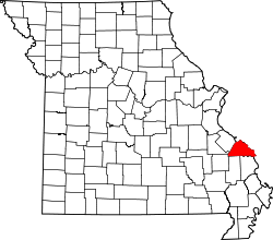 | |
| Villages | ||
| Townships | ||
| CDP | ||
| Other unincorporated communities | ||
| Abandoned villages | ||
| Footnotes | ‡This populated place also has portions in an adjacent county or counties | |