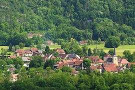
Saint-Christophe-sur-Guiers
| Saint-Christophe-sur-Guiers | ||
|---|---|---|
 | ||
| ||
 Saint-Christophe-sur-Guiers | ||
|
Location within Auvergne-Rhône-Alpes region  Saint-Christophe-sur-Guiers | ||
| Coordinates: 45°26′17″N 5°46′29″E / 45.4381°N 5.7747°ECoordinates: 45°26′17″N 5°46′29″E / 45.4381°N 5.7747°E | ||
| Country | France | |
| Region | Auvergne-Rhône-Alpes | |
| Department | Isère | |
| Arrondissement | Grenoble | |
| Canton | Saint-Laurent-du-Pont | |
| Intercommunality | Cœur de Chartreuse | |
| Government | ||
| • Mayor (2014–2020) | Nicole Vérard | |
| Area1 | 23.54 km2 (9.09 sq mi) | |
| Population (2011)2 | 832 | |
| • Density | 35/km2 (92/sq mi) | |
| Time zone | CET (UTC+1) | |
| • Summer (DST) | CEST (UTC+2) | |
| INSEE/Postal code | 38376 / 38380 | |
| Elevation | 386–1,761 m (1,266–5,778 ft) | |
|
1 French Land Register data, which excludes lakes, ponds, glaciers > 1 km² (0.386 sq mi or 247 acres) and river estuaries. 2 Population without double counting: residents of multiple communes (e.g., students and military personnel) only counted once. | ||

Saint-Christophe-sur-Guiers is a commune in the Isère department in southeastern France.
La Ruchère
La Ruchère, rural district, mainly famous for cross country skiing slopes, was fasten to Saint-Christophe-sur-Guiers in 1794.
Population
| Historical population | ||
|---|---|---|
| Year | Pop. | ±% |
| 1793 | 366 | — |
| 1806 | 1,018 | +178.1% |
| 1821 | 1,062 | +4.3% |
| 1831 | 1,300 | +22.4% |
| 1841 | 1,368 | +5.2% |
| 1851 | 1,306 | −4.5% |
| 1861 | 1,065 | −18.5% |
| 1872 | 971 | −8.8% |
| 1881 | 894 | −7.9% |
| 1891 | 846 | −5.4% |
| 1901 | 769 | −9.1% |
| 1911 | 747 | −2.9% |
| 1921 | 607 | −18.7% |
| 1931 | 579 | −4.6% |
| 1946 | 552 | −4.7% |
| 1954 | 542 | −1.8% |
| 1962 | 521 | −3.9% |
| 1968 | 442 | −15.2% |
| 1975 | 430 | −2.7% |
| 1982 | 599 | +39.3% |
| 1990 | 709 | +18.4% |
| 1999 | 720 | +1.6% |
| 2006 | 766 | +6.4% |
| 2011 | 832 | +8.6% |
See also
References
| Wikimedia Commons has media related to Saint-Christophe-sur-Guiers. |
This article is issued from Wikipedia - version of the 2/12/2016. The text is available under the Creative Commons Attribution/Share Alike but additional terms may apply for the media files.