Saint-Pierre-d'Entremont, Isère
| Saint-Pierre-d'Entremont | |
|---|---|
 | |
 Saint-Pierre-d'Entremont | |
|
Location within Auvergne-Rhône-Alpes region  Saint-Pierre-d'Entremont | |
| Coordinates: 45°24′58″N 5°51′17″E / 45.4161°N 5.8547°ECoordinates: 45°24′58″N 5°51′17″E / 45.4161°N 5.8547°E | |
| Country | France |
| Region | Auvergne-Rhône-Alpes |
| Department | Isère |
| Arrondissement | Grenoble |
| Canton | Saint-Laurent-du-Pont |
| Intercommunality | Cœur de Chartreuse |
| Government | |
| • Mayor (2014–2020) | Jean-Paul Petit |
| Area1 | 32.31 km2 (12.47 sq mi) |
| Population (2011)2 | 558 |
| • Density | 17/km2 (45/sq mi) |
| Time zone | CET (UTC+1) |
| • Summer (DST) | CEST (UTC+2) |
| INSEE/Postal code | 38446 / 73670 |
| Elevation | 598–2,047 m (1,962–6,716 ft) |
|
1 French Land Register data, which excludes lakes, ponds, glaciers > 1 km² (0.386 sq mi or 247 acres) and river estuaries. 2 Population without double counting: residents of multiple communes (e.g., students and military personnel) only counted once. | |
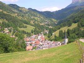
Saint-Pierre-d'Entremont is a commune in the Isère department in the Auvergne-Rhône-Alpes region in southeastern France.
It lies in the parc naturel régional de Chartreuse.
Population
| Historical population | ||
|---|---|---|
| Year | Pop. | ±% |
| 1793 | 771 | — |
| 1806 | 1,102 | +42.9% |
| 1821 | 1,116 | +1.3% |
| 1831 | 1,456 | +30.5% |
| 1841 | 1,520 | +4.4% |
| 1851 | 1,433 | −5.7% |
| 1861 | 1,161 | −19.0% |
| 1872 | 1,127 | −2.9% |
| 1881 | 1,138 | +1.0% |
| 1891 | 1,054 | −7.4% |
| 1901 | 1,004 | −4.7% |
| 1911 | 856 | −14.7% |
| 1921 | 723 | −15.5% |
| 1931 | 703 | −2.8% |
| 1946 | 651 | −7.4% |
| 1954 | 563 | −13.5% |
| 1962 | 503 | −10.7% |
| 1968 | 505 | +0.4% |
| 1975 | 440 | −12.9% |
| 1982 | 459 | +4.3% |
| 1990 | 478 | +4.1% |
| 1999 | 478 | +0.0% |
| 2006 | 555 | +16.1% |
| 2011 | 558 | +0.5% |
Main natural areas
- Grand Som (mountain, 2,026 m)
- Cirque de Saint-Même (waterfalls and natural circus)
- Dent de l'Ours (mountain, 1,820 m)
- Lances de Malissard (mountain, 2,047m)
See also
References
| Wikimedia Commons has media related to Saint-Pierre-d'Entremont (Isère). |
This article is issued from Wikipedia - version of the 1/23/2016. The text is available under the Creative Commons Attribution/Share Alike but additional terms may apply for the media files.