Baillestavy
| Baillestavy | ||
|---|---|---|
|
Baillestavy | ||
| ||
 Baillestavy | ||
|
Location within Occitanie region  Baillestavy | ||
| Coordinates: 42°33′56″N 2°31′33″E / 42.5656°N 2.5258°ECoordinates: 42°33′56″N 2°31′33″E / 42.5656°N 2.5258°E | ||
| Country | France | |
| Region | Occitanie | |
| Department | Pyrénées-Orientales | |
| Arrondissement | Prades | |
| Canton | Vinça | |
| Intercommunality | Vinça Canigou | |
| Government | ||
| • Mayor (2014-2020) | Jacques Taurinya | |
| Area1 | 17.89 km2 (6.91 sq mi) | |
| Population (2012)2 | 103 | |
| • Density | 5.8/km2 (15/sq mi) | |
| Time zone | CET (UTC+1) | |
| • Summer (DST) | CEST (UTC+2) | |
| INSEE/Postal code | 66013 / 66320 | |
| Elevation |
468–1,720 m (1,535–5,643 ft) (avg. 585 m or 1,919 ft) | |
|
1 French Land Register data, which excludes lakes, ponds, glaciers > 1 km² (0.386 sq mi or 247 acres) and river estuaries. 2 Population without double counting: residents of multiple communes (e.g., students and military personnel) only counted once. | ||


Baillestavy (Catalan: Vallestàvia) is a commune in the Pyrénées-Orientales department in southern France.
Geography
Localisation
Baillestavy is located in the canton of Vinça and in the arrondissement of Prades.
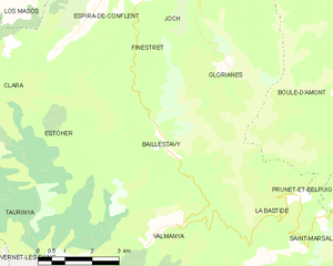
Map of Baillestavy and its surrounding communes
Neighbouring communes
| Espira-de-Conflent (quadripoint) | Finestret | Glorianes | |
| Estoher | |
La Bastide | |
| |||
| | |||
| Valmanya |

Hydrography
Baillestavy is crossed by the Lentillà river, a tributary of the Tech.
Government and politics
Mayors
| Mayor | Term start | Term end |
|---|---|---|
| Joseph Carboneill | 1815[1] | ? |
| Jean Guerre | 193? | 1959 |
| Remy Maler | 1959 | 1971 |
| Alain Taurinya | 1971 | 1989 |
| Claude Maynéris | 1989 | 2001 |
| Jacques Taurinya | 2001 |
Population
| Historical population | ||
|---|---|---|
| Year | Pop. | ±% |
| 1962 | 75 | — |
| 1968 | 54 | −28.0% |
| 1975 | 55 | +1.9% |
| 1982 | 50 | −9.1% |
| 1990 | 53 | +6.0% |
| 1999 | 58 | +9.4% |
| 2007 | 90 | +55.2% |
| 2009 | 94 | +4.4% |
See also
References
External links
| Wikimedia Commons has media related to Baillestavy. |
- (French) Official site
This article is issued from Wikipedia - version of the 10/31/2016. The text is available under the Creative Commons Attribution/Share Alike but additional terms may apply for the media files.