Corneilla-del-Vercol
| Corneilla-del-Vercol Cornellà del Bèrcol | ||
|---|---|---|
|
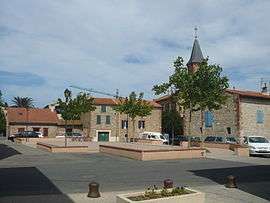
The village square in Corneilla-del-Vercol | ||
| ||
 Corneilla-del-Vercol | ||
|
Location within Occitanie region  Corneilla-del-Vercol | ||
| Coordinates: 42°37′30″N 2°57′07″E / 42.625°N 2.9519°ECoordinates: 42°37′30″N 2°57′07″E / 42.625°N 2.9519°E | ||
| Country | France | |
| Region | Occitanie | |
| Department | Pyrénées-Orientales | |
| Arrondissement | Perpignan | |
| Canton | La Plaine d'Illibéris | |
| Intercommunality | Sud Roussillon | |
| Government | ||
| • Mayor (2014–2020) | Marcel Amouroux | |
| Area1 | 5.43 km2 (2.10 sq mi) | |
| Population (2013)2 | 2,162 | |
| • Density | 400/km2 (1,000/sq mi) | |
| Time zone | CET (UTC+1) | |
| • Summer (DST) | CEST (UTC+2) | |
| INSEE/Postal code | 66059 / 66200 | |
| Elevation |
9–28 m (30–92 ft) (avg. 27 m or 89 ft) | |
|
1 French Land Register data, which excludes lakes, ponds, glaciers > 1 km² (0.386 sq mi or 247 acres) and river estuaries. 2 Population without double counting: residents of multiple communes (e.g., students and military personnel) only counted once. | ||

Corneilla-del-Vercol (Catalan: Cornellà del Bèrcol) is a commune in the Pyrénées-Orientales department in southern France.
Geography
Corneilla-del-Vercol is located in the canton of Elne and in the arrondissement of Perpignan.
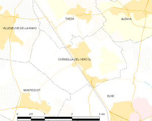
Map of Corneilla-del-Vercol and its surrounding communes
Population
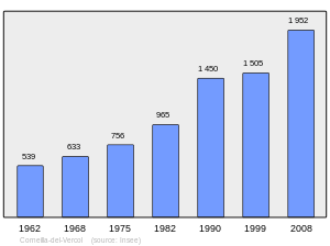
Population 1962-2008
Notable people
- Pierre Jonquères d'Oriola (1920-2011), equestrian born in Corneilla-del-Vercol.
See also
References
| Wikimedia Commons has media related to Corneilla-del-Vercol. |
This article is issued from Wikipedia - version of the 9/28/2016. The text is available under the Creative Commons Attribution/Share Alike but additional terms may apply for the media files.