Fenouillet, Pyrénées-Orientales
| Fenouillet | ||
|---|---|---|
|
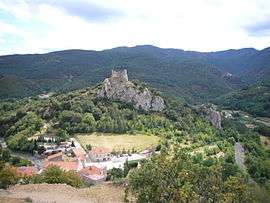
Fenouillet and the Castel Sabarda | ||
| ||
 Fenouillet | ||
|
Location within Occitanie region  Fenouillet | ||
| Coordinates: 42°47′36″N 2°22′52″E / 42.7933°N 2.3811°ECoordinates: 42°47′36″N 2°22′52″E / 42.7933°N 2.3811°E | ||
| Country | France | |
| Region | Occitanie | |
| Department | Pyrénées-Orientales | |
| Arrondissement | Perpignan | |
| Canton | Saint-Paul-de-Fenouillet | |
| Intercommunality | Agly Fenouillèdes | |
| Government | ||
| • Mayor (2001–2008) | Jean-Louis Raynaud | |
| Area1 | 18.76 km2 (7.24 sq mi) | |
| Population (1999)2 | 66 | |
| • Density | 3.5/km2 (9.1/sq mi) | |
| Time zone | CET (UTC+1) | |
| • Summer (DST) | CEST (UTC+2) | |
| INSEE/Postal code | 66077 / 66220 | |
| Elevation |
373–1,208 m (1,224–3,963 ft) (avg. 444 m or 1,457 ft) | |
|
1 French Land Register data, which excludes lakes, ponds, glaciers > 1 km² (0.386 sq mi or 247 acres) and river estuaries. 2 Population without double counting: residents of multiple communes (e.g., students and military personnel) only counted once. | ||

Fenouillet is a commune in the Pyrénées-Orientales department in southern France.
Geography
Fenouillet is located in the canton of Saint-Paul-de-Fenouillet and in the arrondissement of Perpignan.

Map of Fenouillet and its surrounding communes
Population

Population 1962-2008
Sites of interest
- The Château Vicomtal Saint-Pierre de Fenouillet is a ruined 11th century castle.
See also
References
| Wikimedia Commons has media related to Fenouillet (Pyrénées-Orientales). |
This article is issued from Wikipedia - version of the 3/15/2016. The text is available under the Creative Commons Attribution/Share Alike but additional terms may apply for the media files.