Latour-Bas-Elne
| Latour-Bas-Elne | |
|---|---|
|
Latour-Bas-Elne, with the Albera Massif in the background | |
 Latour-Bas-Elne | |
|
Location within Occitanie region  Latour-Bas-Elne | |
| Coordinates: 42°36′26″N 3°00′11″E / 42.6072°N 3.0031°ECoordinates: 42°36′26″N 3°00′11″E / 42.6072°N 3.0031°E | |
| Country | France |
| Region | Occitanie |
| Department | Pyrénées-Orientales |
| Arrondissement | Perpignan |
| Canton | La Côte Radieuse |
| Intercommunality | Sud Roussillon |
| Government | |
| • Mayor (2008–2014) | Pierre Roge |
| Area1 | 3.31 km2 (1.28 sq mi) |
| Population (1999)2 | 1,711 |
| • Density | 520/km2 (1,300/sq mi) |
| Time zone | CET (UTC+1) |
| • Summer (DST) | CEST (UTC+2) |
| INSEE/Postal code | 66094 / 66200 |
| Elevation |
4–29 m (13–95 ft) (avg. 12 m or 39 ft) |
|
1 French Land Register data, which excludes lakes, ponds, glaciers > 1 km² (0.386 sq mi or 247 acres) and river estuaries. 2 Population without double counting: residents of multiple communes (e.g., students and military personnel) only counted once. | |

Latour-Bas-Elne (Catalan: La Torre d'Elna) is a commune in the Pyrénées-Orientales department in southern France.
Geography
Latour-Bas-Elne is located in the canton of La Côte Radieuse and in the arrondissement of Perpignan.

Map of Latour-Bas-Elne and its surrounding communes
Population
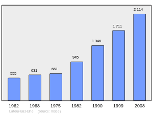
Population 1962-2008
See also
References
| Wikimedia Commons has media related to Latour-Bas-Elne. |
This article is issued from Wikipedia - version of the 12/22/2015. The text is available under the Creative Commons Attribution/Share Alike but additional terms may apply for the media files.