Camélas
| Camélas | |
|---|---|
|
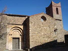
The church of Saint-Fructeux, in Camélas | |
 Camélas | |
|
Location within Occitanie region  Camélas | |
| Coordinates: 42°39′08″N 2°42′20″E / 42.6522°N 2.7056°ECoordinates: 42°39′08″N 2°42′20″E / 42.6522°N 2.7056°E | |
| Country | France |
| Region | Occitanie |
| Department | Pyrénées-Orientales |
| Arrondissement | Perpignan |
| Canton | Thuir |
| Intercommunality | Aspres |
| Government | |
| • Mayor (2014-2020) | Roger Bort |
| Area1 | 12.72 km2 (4.91 sq mi) |
| Population (2012)2 | 417 |
| • Density | 33/km2 (85/sq mi) |
| Time zone | CET (UTC+1) |
| • Summer (DST) | CEST (UTC+2) |
| INSEE/Postal code | 66033 / 66300 |
| Elevation |
118–520 m (387–1,706 ft) (avg. 350 m or 1,150 ft) |
|
1 French Land Register data, which excludes lakes, ponds, glaciers > 1 km² (0.386 sq mi or 247 acres) and river estuaries. 2 Population without double counting: residents of multiple communes (e.g., students and military personnel) only counted once. | |
Camélas (Catalan: Cameles) is a commune in the Pyrénées-Orientales department in southern France.
Geography
Localisation
Camélas is located in the canton of Thuir and in the arrondissement of Perpignan.
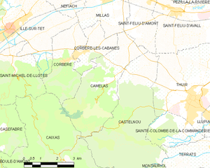
Map of Camélas and its surrounding communes
Neighbouring communes
| Corbère-les-Cabanes | Millas | Saint-Féliu-d'Amont | |
| Corbère | |
||
| |||
| | |||
| Caixas | Castelnou |

Population
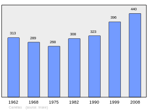
Population 1962-2008
See also
References
| Wikimedia Commons has media related to Camélas. |
This article is issued from Wikipedia - version of the 10/21/2016. The text is available under the Creative Commons Attribution/Share Alike but additional terms may apply for the media files.