Trilla, Pyrénées-Orientales
| Trilla | ||
|---|---|---|
|
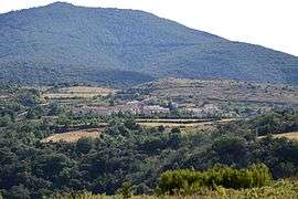
A general view of Trilla | ||
| ||
 Trilla | ||
|
Location within Occitanie region  Trilla | ||
| Coordinates: 42°44′26″N 2°31′12″E / 42.7406°N 2.52°ECoordinates: 42°44′26″N 2°31′12″E / 42.7406°N 2.52°E | ||
| Country | France | |
| Region | Occitanie | |
| Department | Pyrénées-Orientales | |
| Arrondissement | Prades | |
| Canton | Sournia | |
| Intercommunality | Agly-Fenouillèdes | |
| Government | ||
| • Mayor (2001–2014) | Didier Fourcade | |
| Area1 | 8.96 km2 (3.46 sq mi) | |
| Population (2006)2 | 60 | |
| • Density | 6.7/km2 (17/sq mi) | |
| Time zone | CET (UTC+1) | |
| • Summer (DST) | CEST (UTC+2) | |
| INSEE/Postal code | 66216 / 66220 | |
| Elevation |
155–801 m (509–2,628 ft) (avg. 400 m or 1,300 ft) | |
|
1 French Land Register data, which excludes lakes, ponds, glaciers > 1 km² (0.386 sq mi or 247 acres) and river estuaries. 2 Population without double counting: residents of multiple communes (e.g., students and military personnel) only counted once. | ||

Trilla (Occitan: Trilhan) is a French commune in the Pyrénées-Orientales department in southern France.
Its inhabitants are called Trillanais, or Trilhanols in Occitan.
Geography
Trilla is located in the canton of Sournia and in the arrondissement of Prades.
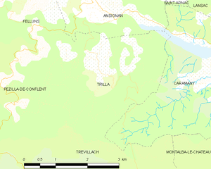
Map of Trilla and its surrounding communes
Population
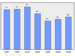
Population 1962-2008
See also
References
| Wikimedia Commons has media related to Trilla. |
This article is issued from Wikipedia - version of the 3/15/2016. The text is available under the Creative Commons Attribution/Share Alike but additional terms may apply for the media files.