Planèzes
| Planèzes | ||
|---|---|---|
|
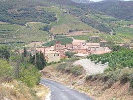
Looking down the road into Planèzes | ||
| ||
 Planèzes | ||
|
Location within Occitanie region  Planèzes | ||
| Coordinates: 42°46′02″N 2°37′11″E / 42.7672°N 2.6197°ECoordinates: 42°46′02″N 2°37′11″E / 42.7672°N 2.6197°E | ||
| Country | France | |
| Region | Occitanie | |
| Department | Pyrénées-Orientales | |
| Arrondissement | Perpignan | |
| Canton | Latour-de-France | |
| Intercommunality | Agly Fenouillèdes | |
| Government | ||
| • Mayor (2008–2014) | Sidney Huillet | |
| Area1 | 6.16 km2 (2.38 sq mi) | |
| Population (2007)2 | 96 | |
| • Density | 16/km2 (40/sq mi) | |
| Time zone | CET (UTC+1) | |
| • Summer (DST) | CEST (UTC+2) | |
| INSEE/Postal code | 66143 / 66720 | |
| Elevation |
97–423 m (318–1,388 ft) (avg. 160 m or 520 ft) | |
|
1 French Land Register data, which excludes lakes, ponds, glaciers > 1 km² (0.386 sq mi or 247 acres) and river estuaries. 2 Population without double counting: residents of multiple communes (e.g., students and military personnel) only counted once. | ||
.svg.png)
Planèzes (Catalan: Planeses) is a commune in the Pyrénées-Orientales department in southern France.
Geography
Planèzes is located in the canton of Latour-de-France and in the arrondissement of Perpignan. Planèzes is part of the Fenouillèdes.

Map of Planèzes and its surrounding communes
Toponymy
In occitan, the name of the commune is Planeses.
Population

Population 1962-2008
See also
External links
References
| Wikimedia Commons has media related to Planèzes. |
This article is issued from Wikipedia - version of the 2/12/2016. The text is available under the Creative Commons Attribution/Share Alike but additional terms may apply for the media files.