Montner
| Montner | ||
|---|---|---|
|
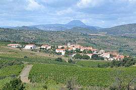
Montner, with the Pic de Bugarach in the background | ||
| ||
 Montner | ||
|
Location within Occitanie region  Montner | ||
| Coordinates: 42°45′00″N 2°40′42″E / 42.75°N 2.6783°ECoordinates: 42°45′00″N 2°40′42″E / 42.75°N 2.6783°E | ||
| Country | France | |
| Region | Occitanie | |
| Department | Pyrénées-Orientales | |
| Arrondissement | Perpignan | |
| Canton | Latour-de-France | |
| Intercommunality | Rivesaltais - Agly - Manadeil | |
| Government | ||
| • Mayor (2008–2014) | Jean-Luc Garrigue | |
| Area1 | 10.98 km2 (4.24 sq mi) | |
| Population (2005)2 | 290 | |
| • Density | 26/km2 (68/sq mi) | |
| Time zone | CET (UTC+1) | |
| • Summer (DST) | CEST (UTC+2) | |
| INSEE/Postal code | 66118 / 66720 | |
| Elevation |
89–500 m (292–1,640 ft) (avg. 120 m or 390 ft) | |
|
1 French Land Register data, which excludes lakes, ponds, glaciers > 1 km² (0.386 sq mi or 247 acres) and river estuaries. 2 Population without double counting: residents of multiple communes (e.g., students and military personnel) only counted once. | ||

Montner is a commune in the Pyrénées-Orientales department in southern France.
Geography
Montner is located in the canton of Latour-de-France and in the arrondissement of Perpignan.

Map of Montner and its surrounding communes
Population
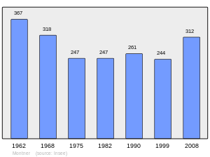
Population 1962-2008
See also
References
| Wikimedia Commons has media related to Montner. |
This article is issued from Wikipedia - version of the 2/12/2016. The text is available under the Creative Commons Attribution/Share Alike but additional terms may apply for the media files.