Trouillas
| Trouillas | ||
|---|---|---|
|
Town center of Trouillas | ||
| ||
 Trouillas | ||
|
Location within Occitanie region  Trouillas | ||
| Coordinates: 42°36′45″N 2°48′33″E / 42.6125°N 2.8092°ECoordinates: 42°36′45″N 2°48′33″E / 42.6125°N 2.8092°E | ||
| Country | France | |
| Region | Occitanie | |
| Department | Pyrénées-Orientales | |
| Arrondissement | Perpignan | |
| Canton | Thuir | |
| Intercommunality | Aspres | |
| Government | ||
| • Mayor (2001–2008) | Rémy Attard | |
| Area1 | 17.01 km2 (6.57 sq mi) | |
| Population (1999)2 | 1,424 | |
| • Density | 84/km2 (220/sq mi) | |
| Time zone | CET (UTC+1) | |
| • Summer (DST) | CEST (UTC+2) | |
| INSEE/Postal code | 66217 / 66300 | |
| Elevation |
58–152 m (190–499 ft) (avg. 77 m or 253 ft) | |
|
1 French Land Register data, which excludes lakes, ponds, glaciers > 1 km² (0.386 sq mi or 247 acres) and river estuaries. 2 Population without double counting: residents of multiple communes (e.g., students and military personnel) only counted once. | ||


Trouillas (Catalan: Trullars) is a commune in the Pyrénées-Orientales department in southern France.
Geography
Trouillas is located in the canton of Thuir and in the arrondissement of Perpignan.
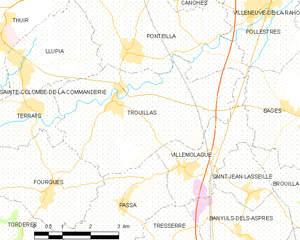
Map of Trouillas and its surrounding communes
Population
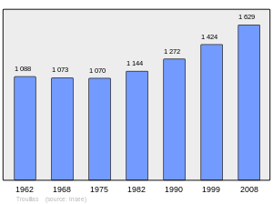
Population 1962-2008
See also
References
| Wikimedia Commons has media related to Trouillas. |
This article is issued from Wikipedia - version of the 2/9/2016. The text is available under the Creative Commons Attribution/Share Alike but additional terms may apply for the media files.