Villelongue-dels-Monts
| Villelongue-dels-Monts Vilallonga dels Monts | ||
|---|---|---|
|
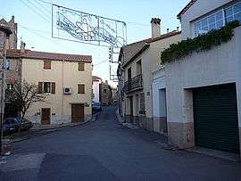
A view within Villelongue-Dels-Monts | ||
| ||
 Villelongue-dels-Monts | ||
|
Location within Occitanie region  Villelongue-dels-Monts | ||
| Coordinates: 42°31′35″N 2°54′15″E / 42.5264°N 2.9042°ECoordinates: 42°31′35″N 2°54′15″E / 42.5264°N 2.9042°E | ||
| Country | France | |
| Region | Occitanie | |
| Department | Pyrénées-Orientales | |
| Arrondissement | Céret | |
| Canton | Argelès-sur-Mer | |
| Intercommunality | Albères | |
| Government | ||
| • Mayor (2001–2008) | Christian Nifosi | |
| Area1 | 11.55 km2 (4.46 sq mi) | |
| Population (2006)2 | 1,346 | |
| • Density | 120/km2 (300/sq mi) | |
| Time zone | CET (UTC+1) | |
| • Summer (DST) | CEST (UTC+2) | |
| INSEE/Postal code | 66225 / 66740 | |
| Elevation |
36–1,030 m (118–3,379 ft) (avg. 117 m or 384 ft) | |
|
1 French Land Register data, which excludes lakes, ponds, glaciers > 1 km² (0.386 sq mi or 247 acres) and river estuaries. 2 Population without double counting: residents of multiple communes (e.g., students and military personnel) only counted once. | ||

Villelongue-dels-Monts (Catalan: Vilallonga dels Monts) is a commune in the Pyrénées-Orientales department in southern France.
The inhabitants are called Villelonguais.
Geography
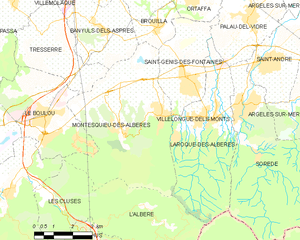
Villelongue-dels-Monts is located in the south of the department of Pyrénées-Orientales, 33 km south of Perpignan, 18 km east from the mediterranean sea and 17 km from the Spanish border by Le Perthus, in the canton of Argelès-sur-Mer and in the arrondissement of Céret.
Its close neighbouring communities are : in the north Banyuls-dels-Aspres, Brouilla and Saint-Génis-des-Fontaines ; in the east Laroque-des-Albères ; in the south l'Albère and in the west Montesquieu-des-Albères.
With a surface of 1155 hectars, the territory represents a form at the same time narrow and long (2 km from east to west and 8 km from north to south). The commune is structured by 3 bigger roads: the RD618 towards Argelès-sur-mer and the RN114 towards Perpignan, the RD11 allowing to join Montesquieu-of-Albères to the west and Laroque-of-Albères and Sorède to the east; the RD11a allows to join the RD618 over a south-north axis.[1]
History
Villelongue-dels-Monts is named after the peak above the village which means « Villelongue-du-Mont ». It was mentioned for the first time in 981. Eventually, the monastery of Saint-Génis-des-Fontaines possessed a freehold on "Villalonga". The phrase "Castrum Sancti Christophori" appeared in 1095 to indicate the fortress constructed on the rocky peak.
Politics and administration
Mayors
|
|
Demography
The communal demography is marked by a certain stability between 1851 and 1975, fluctuating in a minimum of population of 408 in 1968 and a maximum of 533 in 1891, and alternating between the periods of growth and decline.
In 1975, Villelongue-dels-Monts began to grow. The population more than doubled in 30 years, from 513 inhabitants in 1975 to 1346 in 2006.
This growth is largely related to the growth of the metropolitan area of Perpignan.
| Historical population | ||
|---|---|---|
| Year | Pop. | ±% |
| 1851 | 521 | — |
| 1856 | 495 | −5.0% |
| 1861 | 440 | −11.1% |
| 1866 | 454 | +3.2% |
| 1871 | 450 | −0.9% |
| 1876 | 470 | +4.4% |
| 1881 | 514 | +9.4% |
| 1886 | 505 | −1.8% |
| 1891 | 533 | +5.5% |
| 1896 | 520 | −2.4% |
| 1901 | 524 | +0.8% |
| 1906 | 512 | −2.3% |
| 1911 | 506 | −1.2% |
| 1921 | 508 | +0.4% |
| 1926 | 508 | +0.0% |
| 1931 | 506 | −0.4% |
| 1936 | 503 | −0.6% |
| 1946 | 456 | −9.3% |
| 1954 | 528 | +15.8% |
| 1962 | 437 | −17.2% |
| 1968 | 408 | −6.6% |
| 1975 | 513 | +25.7% |
| 1982 | 749 | +46.0% |
| 1990 | 831 | +10.9% |
| 1999 | 1,069 | +28.6% |
| 2004 | 1,230 | +15.1% |
| 2006 | 1,346 | +9.4% |
| Source: commune and INSEE | ||
Sites of interest
See also
References
- ↑ Rapport de présentation - PLU de Villelongue dels Monts
External links
| Wikimedia Commons has media related to Villelongue-dels-Monts. |