Montalba-le-Château
| Montalba-le-Château Montalban lo Castèl | ||
|---|---|---|
|
A general view of Montalba-le-Château | ||
| ||
 Montalba-le-Château | ||
|
Location within Occitanie region  Montalba-le-Château | ||
| Coordinates: 42°41′48″N 2°33′38″E / 42.6967°N 2.5606°ECoordinates: 42°41′48″N 2°33′38″E / 42.6967°N 2.5606°E | ||
| Country | France | |
| Region | Occitanie | |
| Department | Pyrénées-Orientales | |
| Arrondissement | Prades | |
| Canton | Vinça | |
| Intercommunality | Roussillon Conflent | |
| Government | ||
| • Mayor (2008–2014) | Jacques Roigt | |
| Area1 | 15.9 km2 (6.1 sq mi) | |
| Population (1999)2 | 120 | |
| • Density | 7.5/km2 (20/sq mi) | |
| Time zone | CET (UTC+1) | |
| • Summer (DST) | CEST (UTC+2) | |
| INSEE/Postal code | 66111 / 66130 | |
| Elevation |
280–661 m (919–2,169 ft) (avg. 430 m or 1,410 ft) | |
|
1 French Land Register data, which excludes lakes, ponds, glaciers > 1 km² (0.386 sq mi or 247 acres) and river estuaries. 2 Population without double counting: residents of multiple communes (e.g., students and military personnel) only counted once. | ||

.svg.png)
Montalba-le-Château is a commune in the Pyrénées-Orientales department in southern France.
Geography
Localisation
Montalba-le-Château is located in the canton of Vinça and in the arrondissement of Prades.

Map of Montalba-le-Château and its surrounding communes
Neighbouring communes
| Caramany | Bélesta | ||
| Trévillach | |
Ille-sur-Têt | |
| |||
| | |||
| Rodès |

Population
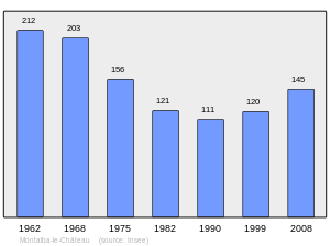
Population 1962-2008
See also
References
| Wikimedia Commons has media related to Montalba-le-Château. |
This article is issued from Wikipedia - version of the 9/28/2016. The text is available under the Creative Commons Attribution/Share Alike but additional terms may apply for the media files.